Schiehallion via main path
Perth and Kinross Walk
County/Area - Perth and Kinross
Author - Peter Smyly
Length - 6.4 miles / 10.4 km Ascent - 2440 feet / 739 metres
Time - 5 hours 40 minutes Grade - moderate
Maps 

| Ordnance Survey Explorer OL49 | Sheet Map | 1:25k | BUY |
| Anquet OS Explorer OL49 | Digital Map | 1:25k | BUY |
| Ordnance Survey Landranger 51 | Sheet Map | 1:50k | BUY |
| Anquet OS Landranger 51 | Digital Map | 1:50k | BUY |
Walk Route Description
Click image to visit gallery of 6 images.
At 3,553 feet, Schiehallion, the Fairy Hill of the Caledonians, is a similar height to Snowdon, the highest peak in Wales (3,560 feet). While you will not expect to find the same crowds as on Snowdon, this is a popular peak in Scotland, helped by its renown and ease of access from a car park. There are divided opinions among hill walkers on the subject of car parks and clear paths and Schiehallion has been the focus of that debate. Some reason that it makes sense because route finding is easy and it helps to avoid unnecessary erosion. Pathless terrain on mountains in the Scottish Highlands often means not a soul in sight and the walk may be more energy-sapping if you need to make your own way over steep terrain comprising tussocky grass, bog and peat hags. Given the particularly rocky terrain of the main ridge, on this walk sturdy footwear is strongly recommended.
While a round trip is normally preferable to a "there and back", in the case of Schiehallion, my preference was to take the most popular route up and down given that any alternative approach would have meant crossing pathless terrain. The path up from the Braes of Foss car park to the north east up to the ridge is so good, that somehow the mile of rocky ridge that follows seems more forgivable accordingly.
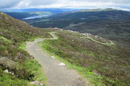
Among the many Munros in Scotland, Schiehallion is both a distinctive name and a distinctive mountain. Therefore, I was a little surprised when a fellow walker at Crianlarich admitted "I don't remember that one" from having climbed it a few years ago. Schiehallion is also a bit of an oddity in the context of it's surroundings as not only is it an isolated peak with a whaleback ridge running roughly from west to east, there is nothing else like it in terms of the topography of the surrounding area as a look at the relevant ordnance survey map will reveal. By way of confirmation, when you descend its eastern slopes on the way back down, the smooth, gentle curves of green and brown hills ahead and to the right illustrate the point. What a contrast this is to the quartzite sea of rocks and stones on the summit ridge of Schiehallion, the like of which it is not easy to compare.
Ascending the peak from the Forestry Commission car park at Braes of Foss the walk falls into two distinct sections. Firstly, the clear, well-constructed path that winds its way up through rocks and heather to reach the main ridge. Then the mile long ridge to the top where stones and rocks underfoot dominate throughout and, of course, this section has to be done in reverse on the descent. Once the path proper comes to an end, there is a vague semblance of a path over rocks but this does not last and a sizeable cairn ahead may cause some to mistakenly think that this is the summit already. However, the ridge passes a number of false summits, though there should be no mistaking the actual summit when it appears especially if you have seen photos of it. The summit cairn is a small pile of rocks on an airy perch, near the edge of a very steep rocky slope to the south. When I did this walk in June 2012, there was a fierce wind blowing on the summit ridge, particularly on the exposed summit which, fittingly in the context of the ridge as a whole, is a jumble of rocks, and while distant views were obscured by cloud, the ridge itself was in sunshine, an unusual combination.
Other walks nearby
| Walk 3354 | Glen Banvie and Blair Castle from the Falls of Bruar | moderate | 11.3 miles |
| Walk 3288 | Ben Vrackie from Moulin (Pitlochry) | moderate | 5.0 miles |
| Walk 1352 | Tarmachan Ridge | mod/hard | 9.4 miles |
| Walk 3067 | Beinn Ghlas & Ben Lawers from near Killin | mod/hard | 6.5 miles |
| Walk 1054 | Beinn Ghlas and Ben Lawers from near Loch Tay | mod/hard | 6.5 miles |
| Walk 3754 | Ben Vrackie & Meall an Daimh from Pitlochry | mod/hard | 8.0 miles |
| Walk 1968 | Loch Turret to Comrie | easy/mod | 8.0 miles |
| Walk 3747 | Ben Chonzie from Loch Turret | mod/hard | 10.0 miles |
| Walk 2185 | Ben Vorlich from Loch Earn | moderate | 6.0 miles |
| Walk 2931 | Creagan an Fhithich from Falls of Truim | easy/mod | 6.3 miles |
Recommended Books & eBooks
No suggestions for this area.Messaging & Social Media
Message Walking Britain and follow the latest news.

Mountain Weather
Stay safe on the mountains with detailed weather forecasts - for iOS devices or for Android devices.