Scafell Pike via Corridor Route from Seathwaite
Lake District Walk
Nat Park - Lake District - Lake District Southern Fells
Wainwrights - Scafell Pike
County/Area - Cumbria
Author - Lou Johnson
Length - 9.5 miles / 15.4 km Ascent - 3200 feet / 970 metres
Time - 8 hours 0 minutes Grade - hard
Maps 

| Ordnance Survey Explorer OL4 | Sheet Map | 1:25k | BUY |
| Anquet OS Explorer OL4 | Digital Map | 1:25k | BUY |
| Ordnance Survey Explorer OL6 | Sheet Map | 1:25k | BUY |
| Anquet OS Explorer OL6 | Digital Map | 1:25k | BUY |
| Ordnance Survey Landranger 90 | Sheet Map | 1:50k | BUY |
| Anquet OS Landranger 90 | Digital Map | 1:50k | BUY |
Walk Route Description
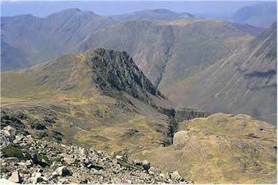
Click image to visit gallery of 5 images.
At 3208 ft (978 m) the summit of Scafell Pike 1s the highest point in England and is a magnet for walkers and tourists alike. Blessed with a fine day - good visibility, lots of sunshine, blue skies, and the necessary energy - we parked at Seathwaite Farm in the idyllic surrounds of upper Borrowdale (grid ref. NY235121). Ready for an ascent of Scafell Pike using the Corridor route.
This classic Lake District walk, recommended by Wainwright himself, took us up the main valley path to Stockley Bridge. From here we turned right and followed Styhead Gill up alongside Taylorgill Force waterfall and on to Styhead Tarn. By the time we reached here the cloud hovering over the summit of Scafell Pike was beginning to lift and our feet surged forward with renewed vigour to reach the first aid box at Sty Head.
The onward path by the corridor route is amazing and far better and quieter than the usual tourist path. Splendid mountain scenery, constant interest and with the summit of Scafell Pike as yet hidden from view. Across the valley Great Gable, Kirk Fell, Pillar and Red Pike (Wasdale) all vie for your attention. Heading for Lingmell Col, you cross several ravines, of which Piers Gill is the most spectacular. Shapely Lingmell is rarely climbed as a main objective, overshadowed as it is by more lofty neighbours. However, the short diversion to its summit cairn is well worth the effort for the views into Wasdale are tremendous.
From Lingmell Col the path turns left uphill, and the next section is a bit of a trudge. However, the path across stony ground is well-marked by cairns and you are soon in sight of the summit cairn on Scafell Pike. Luckily, there were few people on the summit, and we were able to enjoy the solitude and views from this superb mountain.
Eventually we began our descent which is always an anti-climax after summiting a mountain. The first section "downhill" is rocky underfoot and care must is needed. However, the views still occupy your mind and there are worthwhile diversions to the separate summits of Broad and Ill Crags to keep you busy. Ahead of you lies a panorama of the northern fells which is best appreciated by climbing to the summit of Great End which occupies a grand position overlooking Borrowdale and Derwentwater.
The ascent of Great End takes only a few minutes. The extra ascent towards the end of the day can be tough on the legs but the view is worth the pain. If you do add this extension, then return directly to the main Scafell Pike path just above Esk Hause. One advantage of climbing Great End is that you can see most of your route including Styhead Tarn and sections of the corridor route together with Scafell Pike's summit and Lingmell.
Reaching Esk Hause, turn left down to the shelter and left again towards Sprinkling Tarn. Underneath the main buttress of Great End, you take the path down alongside Ruddy Gill which feeds into Grains Gill. This flows back past Stockley Bridge to lead you unerringly back to Seathwaite Farm.
Climbing Scafell Pike is a long fell walk. It took us at least seven hours to complete and that was in fine weather and with reasonable levels of fitness. In theory the fell can be tackled by anyone with some experience and even if the summit is beyond your capabilities, then there is no excuse for not exploring the wonders of the "corridor route" from Sty Head to Lingmell Col.
The paths vary in quality. As far as Lingmell Col it is fairly easy going under foot with only one section where the path is difficult (adjacent to Piers Gill). From Lingmell Col to Esk Hause via Scafell Pike's summit it is hard on your ankles and relatively slow going. Once at Esk Hause, it is easy going all the way back down to Seathwaite.
Other walks nearby
| Walk 1065 | Haystacks | moderate | 5.5 miles |
| Walk 1112 | Great Gable | hard | 7.3 miles |
| Walk 1245 | Castle Crag & Grange | easy/mod | 6.0 miles |
| Walk 1175 | Combe Gill Circuit | moderate | 5.5 miles |
| Walk 3328 | Eagle Crag & Seargeant's Crag from Stonethwaite | moderate | 7.0 miles |
| Walk 3133 | Ullscarf and Watendlath from Stonethwaite | mod/hard | 10.0 miles |
| Walk 1693 | Grange & Watendlath from Rosthwaite | easy/mod | 7.6 miles |
| Walk 1444 | Great Gable (Borrowdale route) | hard | 12.0 miles |
| Walk 1153 | The High Stile Ridge | hard | 10.0 miles |
| Walk 1289 | Fleetwith Pike & Haystacks | moderate | 5.5 miles |
Recommended Books & eBooks
Walking the Lake District Fells - Buttermere
 Part of the Walking the Lake District Fells series, this guidebook covers a wide range of routes to 32 Lakeland summits that can be climbed from the Buttermere, Lorton and Newlands valleys, with highlights including Haystacks, High Stile, Grasmoor and the fells of the Coledale Round. Suggestions for longer ridge routes are also included.
More information
Lake District: High Level and Fell Walks
 This guidebook describes 30 graded fell walks on the ridges and high peaks of the English Lake District, the UK's most popular national park. Reaching some of England's finest and highest mountain scenery, this guide leads readers to classic horseshoes and traditional ascents as well as lesser-known routes to quieter summits.
More information
Messaging & Social Media
Message Walking Britain and follow the latest news.

Mountain Weather
Stay safe on the mountains with detailed weather forecasts - for iOS devices or for Android devices.