Great Sca Fell via Trusmadoor from Longlands
Lake District Walk
Nat Park - Lake District - Lake District Northern Fells
Wainwrights - Brae Fell, Great Sca Fell, Longlands Fell, Meal Fell
County/Area - Cumbria
Author - Lou Johnson
Length - 6.5 miles / 10.6 km Ascent - 1810 feet / 548 metres
Time - 5 hours 0 minutes Grade - moderate
Maps 

| Ordnance Survey Explorer OL4 | Sheet Map | 1:25k | BUY |
| Anquet OS Explorer OL4 | Digital Map | 1:25k | BUY |
| Ordnance Survey Landranger 90 | Sheet Map | 1:50k | BUY |
| Anquet OS Landranger 90 | Digital Map | 1:50k | BUY |
Walk Route Description
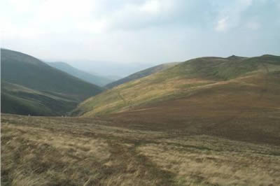
Click image to visit gallery of 5 images.
Before going any further, this Lake District walk is not an ascent of the highest mountain in England but a much quieter destination in the relatively little walked hills to the north of Skiddaw! Although the area has few crags and dramatic mountains it is a great place to walk especially if you want to escape the crowds. Paths are generally grassy and if they become indistinct there are few places where dangerous crags can cause concern so you can amble almost where you please.
The walk starts in Longlands, where limited roadside parking is available alongside a small waterworks (grid ref. NY266358). Go through the gate and follow the grassy track heading south into the hills keeping the stream to your right. The going is easy and progress fast. When the higher ground closes in you need to cross the river (grid ref 274342) and make your way to Trusmadoor. The route is hard to describe and the paths indistinct so some sense of direction is useful to reach this deep valley beneath the eastern slopes of Great Cockup.
Trusmadoor is a dramatic place to linger although the summit of nearby Meal Fell is the next objective and offers a better view. From Trusmadoor follow a track west for a short way before making a direct ascent over grass slopes to the wind shelter and small cairn on the summit of Meal Fell. From here there is a good view of the whole of the walk and it's a good idea to make sure of your whereabouts just in case the weather does deteriorate.
Moving on you head east off the summit on a narrow path that can be clearly seen making for the col just to the north of Great Sca Fell. It is an easy climb and you are soon at the highest point of this excursion. Return to the col and head over Little Sca Fell and take the distinct path heading almost due north to Brae Fell. Situated on the northern fringe of the Lake District there are excellent views north to the Solway Firth and into Scotland.
The final section of the walk takes us over Longlands Fell and care is needed on the first section from Brae Fell's summit. A direct route is impossible because of deeply cut streams and some boggy ground so the best option is to head just east of south until you meet the main valley path. From there Longlands Fell is an easy pathless climb over grass. You are rewarded with a surprisingly good view for such a lowly fell with Over Water and Binsey the two dominant features to the west. All that remains is to follow the ridge north off Longlands Fell to meet the clear track that leads back to where you have parked.
Other walks nearby
| Walk 2244 | Whitewater Dash and Great Calva | moderate | 7.0 miles |
| Walk 2612 | Roughton Gill, Caldbeck Fells | easy | 4.5 miles |
| Walk 2390 | High Pike from Fell Side | moderate | 5.2 miles |
| Walk 1676 | Ullock Pike, Long Side and Carl Side | moderate | 5.5 miles |
| Walk 2040 | Ullock Pike & Carlside | moderate | 5.5 miles |
| Walk 2351 | Caldbeck & Watersmeet from Hesket Newmarket | easy | 4.3 miles |
| Walk 1101 | Carrock Fell, High Pike and Knott | moderate | 11.0 miles |
| Walk 1214 | Carrock Fell & High Pike from Mosedale | moderate | 7.0 miles |
| Walk 2041 | Barf (via the Bishop) and Lords Seat | mod/hard | 4.0 miles |
| Walk 1073 | Skiddaw & Glenderaterra Beck | moderate | 9.0 miles |
Recommended Books & eBooks
Great Mountain Days in the Lake District
 An inspirational guidebook to 50 challenging walks on the high fells of the Lake District. The graded circular routes, between 4 and 14 miles in length, cover classic Lakeland summits like Fairfield, Scafell Pike, Great Gable and Blencathra, to the lesser-known High Spy, King's How and Brund Fell.
More information
Hadrian's Wall Path
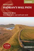 Hadrians Wall Path guidebook to walk the 84 mile National Trail. Described in both directions, the main description is west to east between Bowness-on-Solway and Wallsend, Newcastle, with extensions to Maryport and South Shields. With extensive historical information related to this World Heritage site and separate 1:25,000 OS map booklet included.
More information
Messaging & Social Media
Message Walking Britain and follow the latest news.

Mountain Weather
Stay safe on the mountains with detailed weather forecasts - for iOS devices or for Android devices.