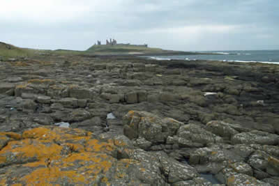
Dunstanburgh Castle from Craster
Northumberland County Walk
County/Area - Northumberland County
Author - Lou Johnson
Length - 4.5 miles / 7.3 km Ascent - 130 feet / 39 metres
Time - 2 hours 20 minutes Grade - easy
Maps 

| Ordnance Survey Explorer 332 | Sheet Map | 1:25k | BUY |
| Anquet OS Explorer 332 | Digital Map | 1:25k | BUY |
| Ordnance Survey Landranger 75 | Sheet Map | 1:50k | BUY |
| Anquet OS Landranger 75 | Digital Map | 1:50k | BUY |
| Ordnance Survey Landranger 81 | Sheet Map | 1:50k | BUY |
| Anquet OS Landranger 81 | Digital Map | 1:50k | BUY |
Walk Route Description
Click image to visit gallery of 3 images.
Craster, famous for its kippers, is a small "working" fishing village north of Alnmouth and provides a suitable starting point for this coastal walk. Park in the National Trust car-park just outside the village (grid ref NU256197) and use the signed footpath that leads down to the harbour. Turn north and follow the broad path that crosses fields towards the dramatically located ruins of Dunstanburgh Castle. Despite the lack of high cliffs, this is a dramatic section of coast especially when a strong northeasterly is blowing! The shore is backed by rocks of a volcanic nature - a dolerite sill - providing a tough barrier to the erosive power of the sea.
Dating from 1314, with a long and often tempestuous history, Dunstanburgh is the largest of the Northumberland Castles and is open to the public. Stay with the main path until you almost reach the castle entrance before veering left to follow a clear path skirting the western side of the fortifications. This leads to the south end of Embleton Bay.
Following the coastal path, cross the golf course to reach a pleasant section along the dunes at the back of the beach - of particular note are the swirls of lava that can be seen on this section just above high water mark. Approximately one mile after the castle turn inland to Dunstan Steads farm, recrossing the golf course on a clear path.
At the farm turn left on a signed paved track through the farm. This leads through fields to reach Dunstan Square after another mile or so. Climb the stile and turn left on the signed footpath. This leads up through the Heughs (a dolerite escarpment) to drop down to the path used on the outward route. Retrace your steps back to the car park.
Other walks nearby
| Walk 2282 | Bewick Moor | moderate | 9.1 miles |
| Walk 3522 | Bamburgh Castle circular | easy/mod | 7.5 miles |
| Walk 2738 | Budle Bay from Bamburgh | easy | 4.0 miles |
| Walk 1805 | An introduction to the Breamish Valley | easy | 2.0 miles |
| Walk 3242 | Holy Island - Lindisfarne Castle & Emmanuel Head | easy | 4.4 miles |
| Walk 3344 | Holy Island & Lindisfarne Castle Circular | easy | 4.3 miles |
| Walk 2095 | Simonside Hills & Rothbury | moderate | 7.9 miles |
| Walk 1766 | Cushat Law and Bloodybush Edge from Hartside | mod/hard | 12.5 miles |
| Walk 2677 | Circuit of Doddington Moor | easy | 3.8 miles |
| Walk 1202 | The Simonside Hills near Rothbury | easy | 4.5 miles |
Recommended Books & eBooks
Walking in Northumberland
 This guidebook contains detailed route descriptions for 36 day walks in Northumberland including the Cheviot Hills. The terrain varies from wild walks and craggy ascents to gentle riverside strolls. Each route ranges from 4 to 16 miles in length and there is the opportunity to link several walks together to create longer treks.
More information
Hadrian's Wall Path
 Hadrians Wall Path guidebook to walk the 84 mile National Trail. Described in both directions, the main description is west to east between Bowness-on-Solway and Wallsend, Newcastle, with extensions to Maryport and South Shields. With extensive historical information related to this World Heritage site and separate 1:25,000 OS map booklet included.
More information
Messaging & Social Media
Message Walking Britain and follow the latest news.

Mountain Weather
Stay safe on the mountains with detailed weather forecasts - for iOS devices or for Android devices.