Back Tor & the Wheel Stones from Fairholme
Peak District Walk
Nat Park - Peak District - Derwent Edge Sheffield
County/Area - Derbyshire
Author - Lou Johnson
Length - 10.3 miles / 16.7 km Ascent - 1200 feet / 364 metres
Time - 6 hours 20 minutes Grade - moderate
Maps 

| Ordnance Survey Explorer OL1 | Sheet Map | 1:25k | BUY |
| Anquet OS Explorer OL1 | Digital Map | 1:25k | BUY |
| Ordnance Survey Landranger 110 | Sheet Map | 1:50k | BUY |
| Anquet OS Landranger 110 | Digital Map | 1:50k | BUY |
Walk Route Description
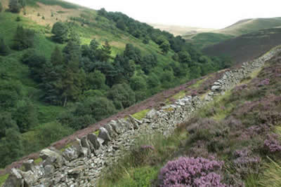
Click image to visit gallery of 8 images.
This excellent Peak District walk starts from the car park at Fairholme (Grid ref. SK172893) beside Ladybower Reservoir. Reached by turning off the A57 Snake Pass road between Sheffield and Glossop the immediate area around the car park is often busy although the crowds soon evaporate as you head for the open country.
After parking head for the Derwent dam and walk across the grassy area immediate below the dam face and take the steps at the eastern end to reach a wide a track. Follow this alongside the reservoir north for well over a mile. Ahead you will see Howden dam and this provides warning of when you need to turn east alongside Abbey Brook and up onto Derwent Edge.
Follow the path on the southern side of Abbey Brook, ignoring the track that climbs more steeply onto the moors, to reach a stile. The path ahead follows a wall, which is on your immediate left. Stay with this path as it climbs above Abbey Brook. The ascent is gradual with a slight loss of height as you cross Cogman Clough. The valley bears south-east and suddenly changes in character with a well defined crag , Barristers Tor, on the opposite of the stream.
The onward route from this point (Grid ref. 197924) diverges right in a southerly direction. The path continues to climb across a rather boggy stretch to reach Lost Lad Hillend (grid ref. 192914) where a more direct but far less interesting path from Derwentwater is joined. The route is now paved for a considerable distance.
Turning south-east, head for the cairn, the Lost Lad, from where good views can be enjoyed on fine days. Continue in the same direction to reach Back Tor, which provides a good place to rest and some shelter in wet weather. The route now turns south and follows Derwent Edge for a considerable distance passing the Cakes of Bread, Dovestone Tor, the Salt Cellar, White Tor and the Wheelstones before dropping down to Whinstone Lee Tor. This edge section is superb offering easy walking and great views.
Descending more steeply you join the path coming in from Cutthroat Bridge. Turn sharp right (north) and follow the bridleway beside the wall to reach a gate on your left (grid ref. 198884). Go through this gate and descend gradually on a westerly heading passing a conifer plantation on your left. The route enters Grindle Clough and descends to meet the lane on the eastern bank of Ladybower Reservoir. Turn right (north) along this lane. En-route for Fairholmes you pass the site of Derwent village, which was flooded when the reservoir was built. Reaching Derwent dam, you retrace your steps back to Fairholme car park.
Other walks nearby
| Walk 1489 | Blackden Brook, Kinder & Upper Ashop | moderate | 6.8 miles |
| Walk 3049 | Bleaklow Stones from Derwent Valley | mod/hard | 12.0 miles |
| Walk 2588 | Win Hill & Hope Cross | moderate | 7.5 miles |
| Walk 3540 | The Derwent Edge from Cutthroat Bridge | moderate | 10.0 miles |
| Walk 1286 | Castleton Great Ridge & Mam Tor | moderate | 8.5 miles |
| Walk 2599 | Kinder Scout and Castleton Ridge from Hope | mod/hard | 13.5 miles |
| Walk 1706 | Win Hill from Hope | easy/mod | 6.5 miles |
| Walk 1159 | Grindsbrook & Edale Head | moderate | 7.5 miles |
| Walk 1264 | Rushup Edge & Crowden Tower | moderate | 10.0 miles |
| Walk 1295 | Ringing Roger & Edale Cross | moderate | 10.0 miles |
Recommended Books & eBooks
Dark Peak Walks
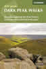 Guidebook to 40 walks in the Dark Peak area of the Peak District National Park. 35 circular routes for most abilities, from 8km to 19km, around Edale, Marsden, Fairholmes, Baslow and Castleton, including Kinder Scout and Mam Tor, and 5 longer (25km to 45km) routes highlighting the best of the Gritstone Edges, High Moorland and Deep Valleys.
More information
Walking in the Peak District - White Peak East
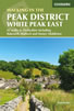 Guidebook describing 42 half-day and day walks in the limestone landscapes of Derbyshire's White Peak, part of the Peak District National Park. One of two volumes, this book covers the east of the region, with potential bases including Bakewell, Eyam, Castleton, Birchover, Matlock and Wirksworth.
More information
Messaging & Social Media
Message Walking Britain and follow the latest news.

Mountain Weather
Stay safe on the mountains with detailed weather forecasts - for iOS devices or for Android devices.