Falls of Kirkaig from Inverkirkaig
Highland Walk
County/Area - Highland - Northern Highland
Author - Lou Johnson
Length - 5.8 miles / 9.4 km Ascent - 950 feet / 288 metres
Time - 3 hours 50 minutes Grade - easy
Maps 

| Ordnance Survey Explorer 442 | Sheet Map | 1:25k | BUY |
| Anquet OS Explorer 442 | Digital Map | 1:25k | BUY |
| Ordnance Survey Landranger 15 | Sheet Map | 1:50k | BUY |
| Anquet OS Landranger 15 | Digital Map | 1:50k | BUY |
Walk Route Description
Click image to visit gallery of 3 images.
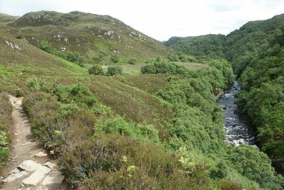
This walk provides a useful introduction to the scenery of Assynt combining a river, loch and mountain views. The start is a small car park (Grid ref. NC085193) beside the River Kirkaig a few miles south of Lochinver on the interesting narrow road that eventually joins the A837 road to Ullapool near Stac Pollaidh.
Leave the car park and take the track on the north side of the River Kirkaig and head upstream. This track soon becomes a path which follows the river into a pleasant glen with small rocky hills on both sides. The clear path climbs well above the river gaining height slowly but steadily. After just over three kilometres there is a path junction. The right-hand path leads down to the Falls of Kirkaig and this will be used later but for now continue upstream by taking the left-hand path.
After a further 800 metres a further and less distinct path junction is encountered. Take the left hand path, which climbs across a low rocky knoll to reach the shores of Fionh Loch. The typical "loch and cnoc" scenery of this area will be seen with the spectacular outline of Suilven rising steeply from this watery landscape.
After enjoying the view return the way you came turning left down the short path to the Falls of Kirkaig. Depending on your agility and nerve, you can get some spectacular views of this cascade, which after rain is truly spectacular. Retrace your steps to the path junction and turn left back to the start.
Other walks nearby
| Walk 1769 | Suilven (North-western approach) | hard | 12.0 miles |
| Walk 1312 | Achmelvich Bay and Alltanabradhan | easy | 3.0 miles |
| Walk 2529 | Stac Pollaidh Circular | easy/mod | 2.8 miles |
| Walk 1017 | Stac Pollaidh | easy/mod | 3.0 miles |
| Walk 2274 | Cul Mor from Knockan Crag | mod/hard | 8.5 miles |
| Walk 1266 | The Old Man of Stoer and the Point of Stoer | easy | 4.5 miles |
| Walk 1317 | Sail Gharbh (Quinag) | moderate | 5.4 miles |
| Walk 3272 | Conival & Ben More Assynt from Inchnadamph | hard | 11.0 miles |
| Walk 1319 | The Bone Caves of Inchnadamph | easy | 3.0 miles |
| Walk 1117 | Glas Bheinn & Eas a' Chual Aluinn (waterfall) | mod/hard | 8.5 miles |
Recommended Books & eBooks
Great Mountain Days in Scotland
 Inspirational guidebook to 50 challenging routes for mountaineers, scramblers, hillwalkers and fell runners, many long enough to backpack over 2 days, especially in winter (12 to 25 miles). A mix of classic routes and unsung gems across Scotland from Galloway to the Outer Hebrides in widely differing wild landscapes. With customised OS mapping.
More information
Walking in Torridon
 This guidebook contains 52 day walks in Torridon, a remote and much-loved area of the Scottish Highlands. Based around Shieldaig and Slioch, the routes are split into 3 sections: easy walks, long and high level walks and mountain ascents over 2000ft including 9 Munros, and 5 outline suggestions for major ridge walks.
More information
Messaging & Social Media
Message Walking Britain and follow the latest news.

Mountain Weather
Stay safe on the mountains with detailed weather forecasts - for iOS devices or for Android devices.