The Bone Caves of Inchnadamph
Highland Walk
County/Area - Highland - Northern Highland
Author - Lou Johnson
Length - 3.0 miles / 4.9 km Ascent - 600 feet / 182 metres
Time - 2 hours 10 minutes Grade - easy
Maps 

| Ordnance Survey Explorer 442 | Sheet Map | 1:25k | BUY |
| Anquet OS Explorer 442 | Digital Map | 1:25k | BUY |
| Ordnance Survey Landranger 15 | Sheet Map | 1:50k | BUY |
| Anquet OS Landranger 15 | Digital Map | 1:50k | BUY |
Walk Route Description
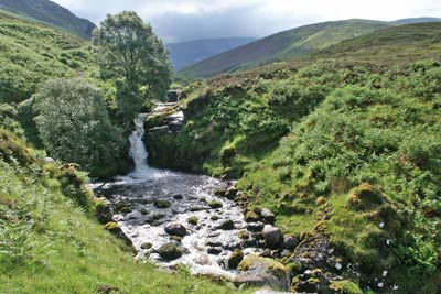
Click image to visit gallery of 6 images.
The bone caves of Inchnadamph provided evidence of creatures that once roamed Scotland's glens and mountains. Although the evidence has been removed the caves nevertheless provide a worthwhile objective for this short and generally easy walk through limestone country. It is worth noting that during and after heavy rain, the dry valley may contain a river that is difficult to cross and the walk may have to be shortened below the caves.
The start is the small car park (Grid ref. NC253179) adjacent to the salmon farm on the east side of the A837 some 3 kilometres south of Inchnadamph towards Ledmore. Leave the car park at its eastern end and follow the clear path up the valley with the river on your right. Continue past the waterfall to reach a spring. In normal conditions the limestone valley upstream is dry with the river flowing underground through the limestone and it exits at this spring. Only after heavy rain the valley does contain a river.
The clear path continues up the valley of the Allt nan Uamh with steep slopes on either side. Slowly the valley narrows and you will see the caves above on the right hand side of the valley in the Creag nan Uamh. At the path junction (grid ref. NC265173) continue ahead ignoring the right hand branch. This leads you across the river and into a side valley with the path doubling back on itself to reach the caves.
Having completed your exploration exit the caves and turn left along the path which leads you back down to the valley path to retrace your steps to the start.
Other walks nearby
| Walk 3272 | Conival & Ben More Assynt from Inchnadamph | hard | 11.0 miles |
| Walk 1317 | Sail Gharbh (Quinag) | moderate | 5.4 miles |
| Walk 1117 | Glas Bheinn & Eas a' Chual Aluinn (waterfall) | mod/hard | 8.5 miles |
| Walk 2274 | Cul Mor from Knockan Crag | mod/hard | 8.5 miles |
| Walk 1769 | Suilven (North-western approach) | hard | 12.0 miles |
| Walk 2529 | Stac Pollaidh Circular | easy/mod | 2.8 miles |
| Walk 1017 | Stac Pollaidh | easy/mod | 3.0 miles |
| Walk 1316 | Falls of Kirkaig | easy | 5.8 miles |
| Walk 1312 | Achmelvich Bay and Alltanabradhan | easy | 3.0 miles |
| Walk 1266 | The Old Man of Stoer and the Point of Stoer | easy | 4.5 miles |
Recommended Books & eBooks
Walking the Munros Vol 2 - Northern Highlands and the Cairngorms
 Guidebook to walking the northern Munros, covering the northern Highlands, the Cairngorms and the Isle of Skye. 70 routes are described, including those up Ben Macdui, Braeriach and Cairn Gorm. Routes range from 7 to 46km, requiring a fair level of fitness. The second of two guidebooks to walking Scotland's Munros: peaks higher than 3000ft.
More information
Great Mountain Days in Scotland
 Inspirational guidebook to 50 challenging routes for mountaineers, scramblers, hillwalkers and fell runners, many long enough to backpack over 2 days, especially in winter (12 to 25 miles). A mix of classic routes and unsung gems across Scotland from Galloway to the Outer Hebrides in widely differing wild landscapes. With customised OS mapping.
More information
Messaging & Social Media
Message Walking Britain and follow the latest news.

Mountain Weather
Stay safe on the mountains with detailed weather forecasts - for iOS devices or for Android devices.