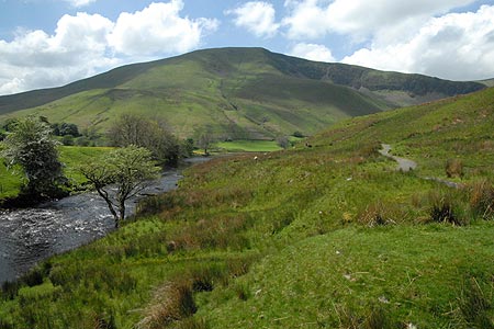
Cautley Spout from Cross Keys
Howgills Walk
Nat Park - Yorkshire Dales - Howgill Fells
Region - Howgills
County/Area - Cumbria
Author - Lou Johnson
Length - 2.0 miles / 3.3 km Ascent - 200 feet / 61 metres
Time - 1 hours 10 minutes Grade - easy
Maps 

| Ordnance Survey Explorer OL19 | Sheet Map | 1:25k | BUY |
| Anquet OS Explorer OL19 | Digital Map | 1:25k | BUY |
| Ordnance Survey Landranger 98 | Sheet Map | 1:50k | BUY |
| Anquet OS Landranger 98 | Digital Map | 1:50k | BUY |
Walk Route Description
Click image to visit gallery of 5 images.
This short walk offers an introduction to the Howgill Fells and provides a grandstand view of one of the area's outstanding natural features, the waterfall of Cautley Spout. The path is clear and easy to follow and there is no uphill walking. The path is generally well maintained although there may be a few wet patches to cross after heavy rain.
The start is the small parking area on the north side of the A683 Sedbergh to Kirkby Stephen road just east of the Cross Keys Inn. Parking is limited and on a fine day space may be at a premium. The Cross Keys is open most days for refreshments.
After parking descend and cross the River Rawthey on the substantial footbridge. Bear left and take the clear path that leads without any navigational difficulties towards the fells. On your immediate right are the slopes of Ben End which lead steeply up to the summit of Yarlside. Ahead is the bulk of Great Dummacks Fell with the rocky outcrop of Cautley Crag scarring the hillside. The path bears right and into a vast amphitheatre with the waterfall of Cautley Spout falling in dramatic fashion down a rocky scar. This is the highest cascade waterfall in England at over 650 feet in height. Obviously it is at its best after heavy rain.
You pass an information board that details Archaeologists' discoveries with houses and fields of an Iron Age farming community unearthed in the valley. It is likely the inhabitants lived by grazing sheep and cattle and growing a few crops in the tiny enclosures close to their simple stone and timber round houses.
Walking towards the base of the falls is worth the effort. There is a path that climbs immediately to the right of the falls. This provides a much closer view but is steep in places and can be slippery underfoot so care is needed.
Other walks nearby
| Walk 2253 | Uldale Falls & Wandale | moderate | 8.5 miles |
| Walk 1389 | Fell End Clouds | easy | 3.0 miles |
| Walk 2438 | Cautley Spout & the Calf from Sedbergh | moderate | 10.0 miles |
| Walk 3008 | Winder & Arant Haw from Sedbergh | moderate | 7.0 miles |
| Walk 1196 | The Calf | mod/hard | 10.5 miles |
| Walk 2458 | Winder, The Calf & Fell Head | moderate | 9.8 miles |
| Walk 3007 | Fell Head & The Calf from Howgill | moderate | 7.5 miles |
| Walk 1342 | Randygill Top from Weasdale | moderate | 6.0 miles |
| Walk 1160 | Wild Boar Fell & Swarth Fell | moderate | 7.0 miles |
| Walk 3385 | Carlingill Beck, Black Force & Whin's End | mod/hard | 6.5 miles |
Recommended Books & eBooks
Walking the Lake District Fells - Keswick
 Part of the Walking the Lake District Fells series, this guidebook covers a wide range of routes to 30 Lakeland summits that can be climbed from Keswick, Whinlatter, Bassenthwaite, Caldbeck, Mungrisdale and Threlkeld, with highlights including Skiddaw and Blencathra. Includes suggestions for longer ridge routes.
More information
Walking in the Yorkshire Dales: North and East
 This guidebook contains 43 circular day walks in the north and east Yorkshire Dales. It explores the dales, hills and moors between Kirkby Stephen and Pateley Bridge. Walking ranges from gentle 3 mile strolls to more strenuous day-long rambles across the Howgills, Wensleydale, Swaledale, Nidderdale, Mallerstang and Coverdale.
More information
Messaging & Social Media
Message Walking Britain and follow the latest news.

Mountain Weather
Stay safe on the mountains with detailed weather forecasts - for iOS devices or for Android devices.