WHW - Day 2 - Dryden to Rowardennan
Stirling Walk
County/Area - Stirling
Author - Peter Smyly
Length - 15.0 miles / 24.4 km
Ascent - nominal or unknown
Time - 7 hours 30 minutes Grade - moderate
Maps 

| Ordnance Survey Explorer 348 | Sheet Map | 1:25k | BUY |
| Anquet OS Explorer 348 | Digital Map | 1:25k | BUY |
| Ordnance Survey Explorer OL39 | Sheet Map | 1:25k | BUY |
| Anquet OS Explorer OL39 | Digital Map | 1:25k | BUY |
Walk Route Description
Click image to visit gallery of 3 images.
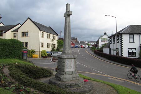
At Drymen, Old Gartmore Road is the main road roughly due north from the general store and is part of the Rob Roy Way which passes the Clachan Inn on the left. This approach is a more direct way of rejoining the WHW than going back along Stirling Road. Old Gartmore Road rejoins the WHW on the left through the Garadhban Forest. This is the first of two days to get used to being near to, or alongside, Loch Lomond. The high point, in terms of altitude, and the highlight of today was Conic Hill (361 metres). A "procession" of walkers was heading along the clear track that snakes its way round the heathery north-eastern side of the hill, though not to the top of it. It is well worth the slight digression up a path, steeply to begin with, to gain the top. This is the nearest the WHW gets to topping anything resembling a mountain though the Devil's Staircase on day 5 bears some similarities. The better viewpoint overlooking Loch Lomond is the most south-westerly knoll, lower down, from where there is an alternative path down, a very steep descent to rejoin the main path. Conic Hill is a popular spot for locals with young children. The view looking down on Loch Lomond and its central cluster of islands ranks as one of the highlights of the WHW.
The village of Balmaha marks the approximate half way point for today's walk and is where the Lowlands meet the Highlands although it is slightly off-route. The WHW descends through woodland to a large car park with a visitor's centre before it continues on its way through woods, Rowardennan-bound. Inchcailloch is a large wooded island offshore from a headland where the WHW takes a seemingly unnecessary, though admittedly short, detour up a wooded hill and then down again to rejoin the shore path at Craigie Fort. Was this detour for the view perhaps? Much of the remainder of today's walk featured a path through woodland and there was some road walking too. The route passes a couple of campsites at Cashel and Sallochy Bay, also the occasional island and a few bays were seen along with shingly beaches and headlands. The drone of traffic from the main road on the other side was sometimes audible across the water. Some bits of the track are steep, especially one uphill section with a series of wooden retainer steps. As the path passes through fairly dense woodland, there is a general absence of landmarks, but a sign appeared at one point saying "Rowardennan 2 km". On emerging from woodland, a tarmac road leads to the Rowardennan Hotel on the left. The Youth Hostel is about 0.75 mile further on.
Eilean Nan Deargannan is a small tree-clad island seen en route to the Youth Hostel, long and narrow and just emerging above the surface of the lake. After miles of either not seeing the loch at all, or only catching brief views of it between trees, the stretch of shoreline between the hotel and the hostel is especially pleasant, as it is largely free from tree cover and there are bays and headlands with water gently lapping on the shore. If following the shoreline, the eye also leads across a bay to the Youth Hostel, set back from a grassy lawn beyond which are tree-clad slopes and, if cloud-free, Ben Lomond is seen towering above.
Click here to continue to part 3
Other walks nearby
| Walk 2347 | Duncryne from Gartocharn | easy | 2.0 miles |
| Walk 2659 | Conic Hill | easy/mod | 4.0 miles |
| Walk 3009 | Ben Lomond | mod/hard | 7.5 miles |
| Walk 1493 | WHW - Day 3 - Rowardennan to Inverarnan | moderate | 14.0 miles |
| Walk 1296 | Beinn Eich & Doune Hill | mod/hard | 8.0 miles |
| Walk 2552 | West Highland Way Experience | moderate | 95.0 miles |
| Walk 1490 | West Highland Way - A personal experience | moderate | 96.0 miles |
| Walk 1491 | WHW - Day 1 - Milngavie to Drymen | moderate | 12.0 miles |
| Walk 2413 | Ben Venue from Loch Achray | moderate | 8.2 miles |
| Walk 2309 | Ben A'an from Loch Achray | easy/mod | 2.5 miles |
Recommended Books & eBooks
The West Highland Way
 Guidebook to walking the West Highland Way National Trail, a 95 mile Scottish long-distance route from Milngavie near Glasgow to Fort William, passing Loch Lomond and crossing Rannoch Moor. Suggested itineraries over 6 to 9 days. Includes accommodation guide and pull-out 1:25K OS map booklet.
More information
West Highland Way Map Booklet
 This compact booklet of maps shows the full route of the 95 mile West Highland Way Scottish Long Distance Route, via Loch Lomond and Rannoch Moor. This booklet is included with the Cicerone guidebook to the trail, and shows the full route on Ordnance Survey 1:25,000 maps.
More information
Messaging & Social Media
Message Walking Britain and follow the latest news.

Mountain Weather
Stay safe on the mountains with detailed weather forecasts - for iOS devices or for Android devices.