WHW - Day 3 - Rowardennan to Inverarnan
Stirling Walk
County/Area - Stirling & Argyll and Bute
Author - Peter Smyly
Length - 14.0 miles / 22.8 km
Ascent - nominal or unknown
Time - 7 hours 0 minutes Grade - moderate
Maps 

| Ordnance Survey Explorer OL39 | Sheet Map | 1:25k | BUY |
| Anquet OS Explorer OL39 | Digital Map | 1:25k | BUY |
Walk Route Description
Click image to visit gallery of 3 images.
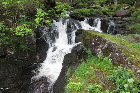
The first few miles today featured long stretches of woodland with only occasional glimpses of Loch Lomond and walkers were few between Rowardennan and Inversnaid. The lack of road access to this side of the loch tends to mean that those who do walk along here are people doing the WHW. At Creag Iolaire, the path divides and the higher level route to the right is reckoned to be the quicker of the two. As the route nears Inversnaid, the track loses height to follow the lake shore. It goes uphill again to present a change in the scenery as it crosses a bridge over a river with a waterfall. Despite the pretty appearance of rhododendrons in bloom, of which there are some here next to the falls, it is regarded as a nuisance locally, partly since it forms a canopy that blocks out sunlight for smaller plants below. Before reaching Inversnaid, there should be a view of Ben Arthur "The Cobbler" across Loch Lomond. Not on this occasion though as the tops were in cloud
The next section is reputed to be tough in places and near to Rob Roy's Cave, which is not seen from the main path, it is necessary to negotiate some steep, rocky sections, though this bit is soon passed. Later, the route involves some rough and rocky terrain near the lake shore with tree roots. The sun came out as tree-clad Eilean I Vow was seen ahead. Another much smaller island is later seen from close to the shore where there is a shingly beach before the route leads away from Loch Lomond over a hill and down towards some old buildings including a bothy at Doune Byre with grey stone walls and slit windows. The bothy was open so there was a chance to look around inside, the first time I had seen the inside of a bothy. One of the best views of Loch Lomond is the last one, a fine retrospect of Eilean I Vow and tree-covered slopes to the left on the mainland, The route leads inland past the hill of Cnap Mor, a possible digression to a viewpoint though all the other WHW walkers at this point were only interested in reaching their next destination. The small reed-fringed Dubh Lochan is passed on the left as the route leads down through woodland past Beinglas Farm with its microlodges and campsite to reach, via a bridge over a river and a main road, Inverarnan. It is only a small place and the Drovers Inn, with its atmospheric bar and a stuffed bear to "welcome" you at the main reception desk is on the main road. It is slightly off-route, requiring a walk back past Beinglas Farm the next day to rejoin the WHW.
Click here to continue to part 4
Other walks nearby
| Walk 3009 | Ben Lomond | mod/hard | 7.5 miles |
| Walk 1296 | Beinn Eich & Doune Hill | mod/hard | 8.0 miles |
| Walk 1298 | The Cobbler | mod/hard | 7.5 miles |
| Walk 1459 | Ben Arthur ("The Cobbler") | mod/hard | 7.5 miles |
| Walk 2659 | Conic Hill | easy/mod | 4.0 miles |
| Walk 2347 | Duncryne from Gartocharn | easy | 2.0 miles |
| Walk 1492 | WHW - Day 2 - Dryden to Rowardennan | moderate | 15.0 miles |
| Walk 2413 | Ben Venue from Loch Achray | moderate | 8.2 miles |
| Walk 2309 | Ben A'an from Loch Achray | easy/mod | 2.5 miles |
| Walk 2317 | Ben Vorlich from Ardlui | mod/hard | 6.8 miles |
Recommended Books & eBooks
The West Highland Way
 Guidebook to walking the West Highland Way National Trail, a 95 mile Scottish long-distance route from Milngavie near Glasgow to Fort William, passing Loch Lomond and crossing Rannoch Moor. Suggested itineraries over 6 to 9 days. Includes accommodation guide and pull-out 1:25K OS map booklet.
More information
West Highland Way Map Booklet
 This compact booklet of maps shows the full route of the 95 mile West Highland Way Scottish Long Distance Route, via Loch Lomond and Rannoch Moor. This booklet is included with the Cicerone guidebook to the trail, and shows the full route on Ordnance Survey 1:25,000 maps.
More information
Messaging & Social Media
Message Walking Britain and follow the latest news.

Mountain Weather
Stay safe on the mountains with detailed weather forecasts - for iOS devices or for Android devices.