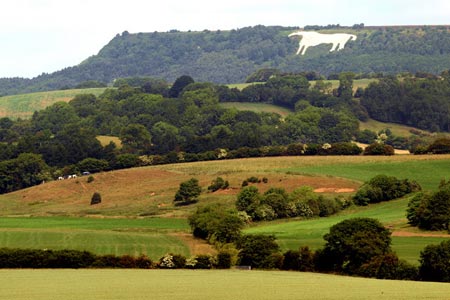
Kilburn White Horse, Cold Kirby, Murton, & Sutton Bank
North York Moors Walk
Nat Park - North York Moors - North York Moors West
County/Area - North Yorkshire
Author - Andy Chaplin
Length - 14.0 miles / 22.8 km Ascent - 1100 feet / 333 metres
Time - 8 hours 10 minutes Grade - moderate
Maps 

| Ordnance Survey Explorer OL26 | Sheet Map | 1:25k | BUY |
| Anquet OS Explorer OL26 | Digital Map | 1:25k | BUY |
| Ordnance Survey Landranger 100 | Sheet Map | 1:50k | BUY |
| Anquet OS Landranger 100 | Digital Map | 1:50k | BUY |
Walk Route Description
Click image to see photo description.
This is another North York Moors walk that follows the Cleveland Way (CW) in bite-size pieces. It starts from the free Forestry Commission parking just below the White Horse at grid reference SE514813 although it is obviously also possible to start from National Park Moors Centre above Sutton Bank if the car parks around "the horse" are full.
From the car park climb up the steps at the side of the horse, continue along the top and then follow the path below and at the side of the glider club. The view off the cliffs to the left are spectacular and you may see gliders taking off or landing on the field to your right.
Past the club, take the path on the right signposted Cleveland Way to Hambleton, follow it through the trees, cross the A170 and walk along the road past the Hambleton Inn. Staying on the CW, turn left off the road and follow the track towards Hampleton House. The CW turns off right, in front of the house and keeps to the right of the horse-exercising track. There is a left turn after the exercising field and a right turn onto the Cote Moor Road track.
At the road turn right into Cold Kirby and take the left hand road at the fork before the church then go left on the bridleway that passes through Ailred Barn. Keep going through the buildings, through a couple of gates then straight on over the fields. This and the next bridleway, after crossing Back Lane, are clearly visible. Carry on and cross Wethercote Lane.
As you approach the woods in front of you keep over to the fence on the right and you will pick up the path that descends down through Murton Wood. It can be muddy and slippery as the track descends down to and then crosses Limperdale and Sledhill Gills. Going up the other side it is a track - half way up you can choose to stay on the farm track or take the bridleway - they merge again shortly afterwards.
Carry on along the track then join the road - still going towards Murton Grange. At the junction with Peak Scar Road take the bridleway on the other side that leads down Peak Scar Gill. There are now views to the right into Ryedale, with Hawnby Hill and the Bilsdale transmitter clearly visible. When you cross the gill the track doubles back up the opposite side and when it comes out of the wood and starts to turn north westwards take the bridleway that goes sharply uphill, off on the left.
Going uphill you pass a ruined cottage and can then see the buildings at Noddle End. There are grouse feeding paths along the hill crest to your right - ignore these and head for the Noddle End buildings. The bridleway then continues as a green farm track alongside the wall on your left until Gowerdale Wood - off on your right - comes to an end and you reach a gate that marks the start of open country. Continue straight on with the wall still on your left and you come to the information board about Sneck Yate.
Go straight over the Hambleton Street track on the Cleveland Way to High Paradise. Past the house/tearooms take the road downhill then follow the CW sign off on the left as the road bends to the right. Go down then up and through the end of Boltby Forest then cross Sneck Yate Bank road.
The CW path to Sutton Bank is clearly marked all the way with great views from Boltby Scar, Whitestone Cliff and Sutton Brow. As you get closer to Sutton Bank the path is split between walking and bike-riding which makes it easy going. Cross the A170 at Sutton Bank and continue along the path signed to the White Horse. Shortly afterwards you are back on the path you had started on - and have a better view of Ivy Scar as you approach it this time - and only have the knee-jarring descent to the car parking remaining in order to complete the walk.
Other walks nearby
| Walk 2566 | Rievaulx Abbey from Kilburn, near Thirsk | mod/hard | 15.0 miles |
| Walk 3581 | Gormire Lake from Sutton Bank National Park Centre | easy/mod | 3.4 miles |
| Walk 1524 | Cold Kirby, Rievaulx Bridge & Wass | moderate | 12.5 miles |
| Walk 2702 | Ampleforth, Shallow Dale, Yearsley Moor & Wilderness | moderate | 9.5 miles |
| Walk 1525 | Beck Dale & Rievaulx from Helmsley | moderate | 9.8 miles |
| Walk 1622 | Hawnby, Bilsdale West and Wetherhouse Moors | moderate | 8.3 miles |
| Walk 1704 | Oswaldkirk, Nunnington & Harome circular | moderate | 11.5 miles |
| Walk 1920 | Rievaulx Moor from Cowhouse Bank | moderate | 9.5 miles |
| Walk 1473 | Hollin Hill to Square Corner by the Cleveland Way | moderate | 9.5 miles |
| Walk 1497 | High Paradise around Arden Great Moor from Square Corner | moderate | 14.3 miles |
Recommended Books & eBooks
The Cleveland Way Map Booklet
 Map booklet of the Cleveland Way National Trail, a 177km (110 mile) walk around the North York Moors National Park. This booklet is included with the Cicerone guidebook to the Cleveland Way and the Yorkshire Wolds Way, and shows the full route of the Cleveland Way on Ordnance Survey 1:25,000 maps.
More information
Trail and Fell Running in the Yorkshire Dales
 Guidebook to 40 of the best trail and fell runs in the Yorkshire Dales National Park. Ranging from 5 to 24 miles, the graded runs start from bases such as Ribblehead, Dent, Sedbergh, Malham and Grassington and take in the region's diverse delights, from castles and waterfalls to iconic mountains such as Whernside, Ingleborough and Pen Y Ghent.
More information
Messaging & Social Media
Message Walking Britain and follow the latest news.

Mountain Weather
Stay safe on the mountains with detailed weather forecasts - for iOS devices or for Android devices.