Sharp Edge & Blencathra from Scales
Lake District Walk
Nat Park - Lake District - Lake District Northern Fells
Wainwrights - Blencathra
County/Area - Cumbria
Author - Peter Smyly
Length - 5.0 miles / 8.1 km Ascent - 2100 feet / 636 metres
Time - 4 hours 40 minutes Grade - mod/hard
Maps 

| Ordnance Survey Explorer OL5 | Sheet Map | 1:25k | BUY |
| Anquet OS Explorer OL5 | Digital Map | 1:25k | BUY |
| Ordnance Survey Landranger 90 | Sheet Map | 1:50k | BUY |
| Anquet OS Landranger 90 | Digital Map | 1:50k | BUY |
Walk Route Description
Click image to see photo description.
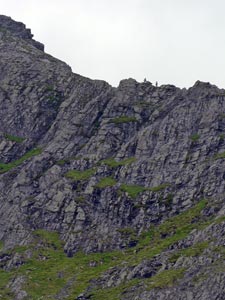
This is a Lake District walk that features one of Lakeland's renowned peaks (Blencathra) as well as one of its highly regarded and challenging approach routes. Sharp Edge is one of those narrow ridges which is likely to be viewed as either an exciting challenge or a horror to be avoided, depending on your personal view. One thing is certain and that is, to cope with the challenge, you need a good head for heights as there are parts of it where exposure to big drops is unavoidable. I would not recommend it, in any case, in winter conditions, rain or strong winds. Further, Sharp Edge is only part of the challenge since Foule Crag then has to be ascended to gain the summit ridge.
Park in the village of Scales off the A591 between Keswick and Penrith and follow the path ahead to the west of Mousthwaite Comb which takes you on a diagonal uphill route until you top the brow of the ridge ahead. Next the route follows a more gentle trajectory with the River Glenderamackin below to the right and you have a first distant glimpse of Sharp Edge and Foule Crag ahead. From here it seems inconceivable that there could be a way up Foule Crag for walkers since it appears to be almost vertical. Ascent is gained as the path leads up by the stream which comes out of Scales Tarn (Scales Beck, fittingly enough) and the tarn itself is a good point to stop for a pause before the main challenge of the walk is undertaken. From the tarn, Blencathra towers above while the narrow arête of Sharp Edge arrests the attention to the right. You may see tiny ant like figures on the crest of the arête above. The approach to Sharp Edge from the tarn is steep enough but pales in comparison with what comes next once the arête is reached. Basically there are two choices. Those who are bold and unfazed by a narrow ridge with a plunging drop off to one side will follow the crest of the ridge. People who are more cautious may follow a narrow path to the right which, to begin with, avoids anything the least bit scary but this path peters out and it becomes essential to go up on to the arête proper. Once the arête has been traversed, Foule Crag looms immediately ahead and this rocky cliff may well appear insurmountable. In my view, the best approach from here, is to locate a kind of three-sided chimney which cuts off the sense of exposure and at the same time has ample foot and hand holds. Once the chimney top has been reached, then it is an easy to walk up to the summit ridge of Blencathra more or less due south. From here there is a dramatic view looking down on the near-circular Scales Tarn now way below and the walk to the summit is on more or less level ground.
For the descent, by way of variation this route goes down the Halls Fell ridge, more or less due east from the top of Blencathra. Although nothing like as difficult as Sharp Edge, this is nevertheless, a steep and rocky ridge where the use of hands may be necessary in places to clamber over rock outcrops. In any case, Sharp Edge could not be recommended as a descent route. By branching south down Doddick Fell, a return to the car park can be made along the valley via Doddick Farm.
Alternatively, those not wishing to attempt Sharp Edge could go both up and down Halls Fell to attain the summit of Blencathra. Although this would involve a steep, rocky ascent, it is nothing like as hazardous or vertiginous as Sharp Edge across the other side of Scales Tarn.
Other walks nearby
| Walk 1354 | Bannerdale Crags & Souther Fell | moderate | 7.5 miles |
| Walk 1073 | Skiddaw & Glenderaterra Beck | moderate | 9.0 miles |
| Walk 1244 | Lonscale Fell & Latrigg | moderate | 7.5 miles |
| Walk 2364 | Clough Head via Great Dodd from near Dockray | moderate | 8.1 miles |
| Walk 1101 | Carrock Fell, High Pike and Knott | moderate | 11.0 miles |
| Walk 1214 | Carrock Fell & High Pike from Mosedale | moderate | 7.0 miles |
| Walk 2587 | Castlerigg Stone Circle & St John's in the Vale | easy/mod | 8.5 miles |
| Walk 1158 | High Rigg | easy | 5.5 miles |
| Walk 2005 | High Rigg & Legburthwaite | easy | 5.5 miles |
| Walk 2049 | Calfhow Pike & the Dodds from Legburthwaite | moderate | 7.5 miles |
Recommended Books & eBooks
Outdoor Adventures with Children - Lake District
 Guidebook to 40 outdoor adventures in the Lake District with children under 12, including walking, cycling, orienteering, paddling, boating, hostelling and more. Graded activities for varying age ranges or for families with children of different ages.
More information
The Cumbria Way
 A guidebook to the 73 mile Cumbria Way, an easy long-distance walk though the heart of the Lake District National Park, from Ulverston in the south to Carlisle in the north, with good transport links to either end. The route is largely low-level but this guide offers alternative mountain days to climb some of the famous fells en route.
More information
Messaging & Social Media
Message Walking Britain and follow the latest news.

Mountain Weather
Stay safe on the mountains with detailed weather forecasts - for iOS devices or for Android devices.