Gibbet Hill & the Devil's Punch Bowl from Haslemere
Surrey Walk
County/Area - Surrey
Author - Peter Smyly
Length - 7.0 miles / 11.4 km Ascent - 800 feet / 242 metres
Time - 4 hours 20 minutes Grade - easy/mod
Maps 

| Ordnance Survey Explorer OL33 | Sheet Map | 1:25k | BUY |
| Anquet OS Explorer OL33 | Digital Map | 1:25k | BUY |
| Ordnance Survey Landranger 176 | Sheet Map | 1:50k | BUY |
| Anquet OS Landranger 176 | Digital Map | 1:50k | BUY |
Walk Route Description
Click image to visit gallery of 8 images.
Gibbet Hill (892 feet) is the second highest hill in Surrey after Leith Hill and the tree-clad combe of the Devil's Punch Bowl is one of Surrey's better-known landmarks. .In April 2015, tree-felling activities had resulted in the nearby Punch Bowl being visible from the top of Gibbet Hill. The village of Hindhead, a mile to the west of the Punchbowl is the usual starting point for a walk up Gibbet Hill. However, this walk takes a longer approach route by starting from the town of Haslemere to the south east, passing along a leafy country lane and part of the Greensand Way.
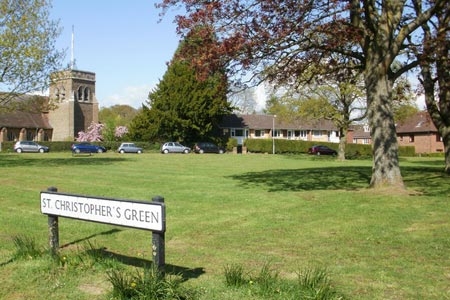
If travelling by train, the railway station at Haslemere is a convenient start and finishing point. From the station, follow the main road to the right as far as the triangular green. Turn right here past the church to locate Farnham Lane (ignoring Bunch Lane) leading uphill. Trees either side of the road soon meet overhead to form a canopy in places, a bit like a tunnel. The walk passes Stoatley Hollow (road name) to the right. Follow the road ahead passing through a residential area until a public bridleway sign appears on the left. Ignore this, but a little further one, also on the left, you reach a public footpath sign on the left with a "GW" (Greensand Way) waymarker.
A path now winds through woodland to a crossroads. Turn right here to reach a car park with a noticeboard. The path forks here. Take the one on the right that leads to a straight landrover wide track at a T. Turn left here and you can just glimpse Farnham Lane to the right. Scots pine trees and yellow gorse abound as the route leads to Gibbet Hill. At one point a track to the left includes an option for "Hidden Hindhead", one of the local walking routes. An optional digression to the right offers a view across the valley and back towards the houses of Haslemere. A bench offers a chance to sit down next to a giant Scots pine tree. Returning to the main route, the plateau like top of Gibbet Hill is soon reached with its trig point and Celtic Cross.
To reach the Devil's Punchbowl, cross over to the narrow tarmac road that borders the rim of the Punch Bowl and follow it towards the north. People who have been here prior to 2011 when the Hindhead Tunnel was opened will remember the busy three lanes of traffic of the A3. Now you are more likely to see the odd jogger with a dog running alongside or a few ramblers while the only sound is likely to be that of wind rushing in the trees or birds singing.
A path continues on the other side of the former A3 to reach a hill which is unnamed on the ordnance survey map (757 feet). From the hill, follow the path down the other side which turns to the left and then the right as it goes down into the Punch Bowl. The route passes Hindhead Youth Hostel, set in a secluded location.
Next take the path due west from the hostel, crossing a stream before going up the other side and turning south. The path gradually rises in places to lead all the way to the former A3 road. Depending on the time of year, and in turn, how many leaves there are on the trees, you may find that views of the Punch Bowl to the left are at best intermittent. At the top of the rise, take a path off to the left shortly before the former road which leads initially to a point where there is a good view looking down on the Punch Bowl. The path then goes down a hill to the foot of the Punch Bowl. From here, one option is to walk up the other side to near the top of the sloping hillside, not far from the former A3 road above and bear left. Although this route is mostly pathless, the right general direction is clear even if it does mean a bit of a meandering route to avoid gorse bushes. This route leads to a car park which is very near the T junction leading from Gibbet Hill which is the way to go next.
For the return walk, instead of reversing the outward route, by way of variation, take the narrow path to the south east of the trig point at the top of Gibbet Hill. The path soon loses height quite rapidly as it goes down through the trees and leads to a crossroads of footpaths at the bottom of the hill. Turn right and follow the path ahead. By trending due south, the path through the trees emerges on to a tarmac road, a quiet residential area with a few houses. Follow the road ahead until you reach a T junction and turn right. This road, Bunch Lane, passes Stoatley Hollow and Stoatley Rise on the right before emerging on Farnham Lane just a short distance before the walk's starting point. Alternatively, from the top of Gibbet Hill, simply reverse the outgoing route.
Other walks nearby
| Walk 3228 | Black Down from Haslemere | easy/mod | 10.0 miles |
| Walk 1424 | Midhurst Way - Haslemere Stn to Midhurst Bus Stn | moderate | 9.5 miles |
| Walk 2232 | Midhurst and Woolbeding | easy/mod | 6.0 miles |
| Walk 1425 | Midhurst Way - Petworth to Midhurst | easy/mod | 5.5 miles |
| Walk 3406 | The Wey & Arun Canal, Loxwood | easy | 4.5 miles |
| Walk 1976 | Noar Hill from Selborne | easy/mod | 5.0 miles |
| Walk 1869 | Thorncombe Street from Bramley | easy/mod | 6.0 miles |
| Walk 3693 | Alton to Farnham using St Swithun's Way | moderate | 12.0 miles |
| Walk 1835 | Treyford & Didling from Hooksway | easy/mod | 6.0 miles |
| Walk 1872 | Charlton, Singleton & Goodwood Circular | easy/mod | 6.5 miles |
Recommended Books & eBooks
No suggestions for this area.Messaging & Social Media
Message Walking Britain and follow the latest news.

Mountain Weather
Stay safe on the mountains with detailed weather forecasts - for iOS devices or for Android devices.