Chalfont and Latimer, Flaunden and Chorleywood
Chilterns Walk
Region - Chilterns
County/Area - Buckinghamshire & Hertfordshire - South Buckinghamshire
Author - Peter Smyly
Length - 11.7 miles / 19 km Ascent - 1200 feet / 364 metres
Time - 7 hours 0 minutes Grade - moderate
Maps 

| Ordnance Survey Explorer 172 | Sheet Map | 1:25k | BUY |
| Anquet OS Explorer 172 | Digital Map | 1:25k | BUY |
| Ordnance Survey Landranger 165 | Sheet Map | 1:50k | BUY |
| Anquet OS Landranger 165 | Digital Map | 1:50k | BUY |
| Ordnance Survey Landranger 166 | Sheet Map | 1:50k | BUY |
| Anquet OS Landranger 166 | Digital Map | 1:50k | BUY |
Walk Route Description
Click image to visit gallery of 12 images.
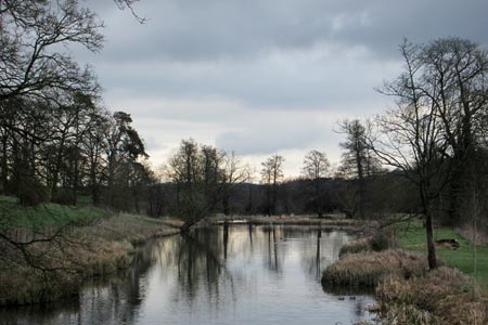
This is another walk that links two tube stations on the Metropolitan line of the London Underground and which offers some tranquil rural scenery that is far removed from city life. The route takes in parts of the Chess Valley walk at the start and end of the route and a section of the Chiltern Way in between. There is a variety of scenery with undulating landscapes, pastoral scenes of grazing animals, fields of wild flowers in summer, a cricket pitch, a golf course, a quarry, two churches and the shallow chalk stream of the River Chess. This river is frequently elusive but it occasionally provides close-up views of it's crystal clear waters and riverside vegetation, in particular at Sarratt Bottom on this route.
One slight downside of the walk is the need to follow some country lanes in order to connect some of the public footpaths although part of the Chiltern Way involves some road walking. There are many paths and bridleways in the area offering options to vary the route depending on time, weather and personal preferences. The route could, for instance, be concluded by returning to Chalfont and Latimer from Sarratt Bottom by following the Chess Valley towards Chesham.
From Chalfont and Latimer station, exit the car park and follow the main road to the left under the railway bridge. Take the next road on the left (Bedford Avenue) parallel to the railway line and then turn down Chenies Avenue on the right, and go ahead at the crossroads. At the end of Chenies Avenue, a path leads down through woodland, across a road and a field and the first view of the River Chess is seen on the right with the weir of the Great Water on the left. Follow the lane uphill to the right and then turn left along a narrow fenced path with a view looking down on the Great Water below, one of the better views of the walk. This is part of the Chess Valley (CV) route and, after skirting a field, the route enters woodland at a sign and goes down a narrow path where nettles may try to encroach in places. The route leads across a couple of fields and Blackwell Farm is reached. Follow the signs for the CV walk that passes between farm buildings. One section here can be very muddy after rainfall but on this occasion (May 2015) the ground was rock hard and cracked in places.
Broadwater Bridge is a route junction for walkers and you leave the CV route here to take a path uphill through woodland to the right. Ignore the first option to branch right down Bunn's Lane but continue ahead along a narrow path with partially encroaching vegetation either side to reach a T of public bridleways. Turn right here along a woodland track that leads to a road, Green Lane. Next follows a section of road walking. Follow the road round to the left, and then left again at the next junction, then right uphill at the next fork with Chesham and Ley Hill's golf course appearing on the left as the road goes uphill. Turn right at the T junction and then take the public bridleway on the left. As the word bridleway suggests, you are more likely to encounter horse riders along here than walkers. The track offers wide expansive views of undulating landscape and farmland before it passes through woodland then opens out again to descend to Flaunden Bottom. The word "bottom" indicates a shallow valley and Flaunden is the name of the nearest village which is where this route heads next, following the road called Flaunden Hill which turns sharp right at the top of the hill as the village is reached with the church on the right.
Turn left to pass the Green Dragon restaurant on the left and, go ahead at the crossroads and look out for a public footpath sign on the right for the Chiltern Way which is now followed as far as Sarratt with a mixture of field crossings, woodland, narrow country lanes and farmland. The church at Sarratt is a convenient place to stop for a break. The route rejoins the Chess Valley route by descending the grassy hill. There is some private land here but once the path emerges from woodland into the open, there is public access to the right with a footbridge across the chalk stream and a good view of it accordingly. For the concluding section of the walk, the CV route goes beyond New Road, passes through more woodland where it leads over a footbridge. In May 2015, the sloping field the other side of New Road was carpeted with mostly white flowers, presenting a picturesque scene. Before reaching the busy motorway - audible from here - take a track to the right up through woods which becomes an unsurfaced road which leads to Chorleywood with its cricket pitch and common, beyond which is Chorleywood tube station.
Other walks nearby
| Walk 2928 | Amersham to Chorleywood via Chalfont St Giles | easy/mod | 8.5 miles |
| Walk 1517 | Amersham circular via Hyde Heath and Little Missenden | easy/mod | 8.0 miles |
| Walk 1373 | Amersham Old Town Circular | easy/mod | 11.5 miles |
| Walk 1149 | Chesham to Rickmansworth (Chess Valley) | easy/mod | 10.5 miles |
| Walk 1060 | Little Missenden and Amersham | easy/mod | 8.5 miles |
| Walk 1392 | Chesham & Cholesbury Circular | moderate | 16.0 miles |
| Walk 2369 | Chesham & Little Missenden Circular | easy/mod | 9.4 miles |
| Walk 3403 | Chipperfield to Kings Langley Circular | easy | 5.0 miles |
| Walk 1507 | Chipperfield Common circular | easy | 2.0 miles |
| Walk 1815 | Hertfordshire Way between Chipperfield and Bovingdon | easy/mod | 7.5 miles |
Recommended Books & eBooks
No suggestions for this area.Messaging & Social Media
Message Walking Britain and follow the latest news.

Mountain Weather
Stay safe on the mountains with detailed weather forecasts - for iOS devices or for Android devices.