Lud's Church, Back Forest & Clough Head
Peak District Walk
Nat Park - Peak District - The Roaches
County/Area - Staffordshire
Author - Lou Johnson
Length - 6.8 miles / 11.1 km Ascent - 800 feet / 242 metres
Time - 4 hours 10 minutes Grade - easy/mod
Maps 

| Ordnance Survey Explorer OL24 | Sheet Map | 1:25k | BUY |
| Anquet OS Explorer OL24 | Digital Map | 1:25k | BUY |
| Ordnance Survey Landranger 118 | Sheet Map | 1:50k | BUY |
| Anquet OS Landranger 118 | Digital Map | 1:50k | BUY |
| Ordnance Survey Landranger 119 | Sheet Map | 1:50k | BUY |
| Anquet OS Landranger 119 | Digital Map | 1:50k | BUY |
Walk Route Description
Click image to visit gallery of 9 images.
The Roaches and surrounding country can be very busy of fine weekends especially on the western side of the ridge. This Peak District walk explores the 'quieter' side of the Staffordshire Roaches visiting the rocky cleft of Lud's Church before exploring the moorland and woodland of Back Forest and continuing via Clough Head back to the start.
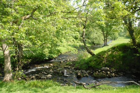
The start is a small car park beside the River Dane on the Staffordshire/Cheshire border close to the Youth Hostel at Gradbach. On busy days parking may be problematic so an early start is recommended. Exit the car park onto the lane and turn right. After 200 metres bear right down the access road to the Hostel, following the footpath signs through the property and alongside the river to reach a footbridge (grid ref. SJ990657).
Cross the footbridge. Ignore the paths either side along the river, instead climbing up amongst the trees to reach a cross path. Turn right towards Lud's Church. The path climbs gently through the woods. A signed diversion leads you to Lud's Church which is on your right. After exploring this rocky cleft, return to the path you have just left and continue to climb soon leaving the woods and entering open country.
The path is clear and improving views over the Dane Valley towards Cheshire soon emerge. The path swings left to reach a path junction (grid ref. SJ977655). Turn left here and follow a clear rising path across the moorland (Back Forest on OS maps). You get a superb view forward to the highest ground of the Roaches with its westerly facing crags dominant. The undulating path eventually descends to a road at Roach End (grid ref. SJ995644).
Here you have the option of climbing to the summit of the Roaches by taking the clear path ahead, which leads without any navigational problems to the summit trig point at 505 metres above sea level. The views are excellent on a clear day and worth the extra effort. This option will add an extra mile and 300 feet of ascent to the walk.
To continue from Roach End, turn left down the signed path which soon becomes a track and continue to descend past Moss End Farm (on your left) to reach a road junction (grid ref. SK008650). Turn sharp left along a walled track towards Cloughhead. The way ahead is never in doubt and after passing through a short section of rough country the path continues through a series of pastures with Gradbach Hill on your right. Continue along this path, passing through a farm onto a lane. Bear right and continue along this lane which leads back to the car park, which is on your right.
Other walks nearby
| Walk 1652 | Three Shires Head | easy | 4.5 miles |
| Walk 2233 | Flash & Three Shires Head | easy/mod | 6.2 miles |
| Walk 1178 | Roaches and Lud's Church | moderate | 7.3 miles |
| Walk 1707 | The Roaches short circular | easy/mod | 5.0 miles |
| Walk 3030 | Roaches & Lud's Church | easy/mod | 7.0 miles |
| Walk 2272 | Flash Circular from Cistern Clough | moderate | 8.0 miles |
| Walk 1728 | Axe Edge Moor & Three Shires Head | easy/mod | 7.2 miles |
| Walk 3136 | Shining Tor & Goyt's Clough | easy/mod | 5.1 miles |
| Walk 1183 | Shining Tor & Axe Edge Moor | moderate | 9.0 miles |
| Walk 1288 | Roaches & Hen Cloud from Tittesworth Reservoir | moderate | 8.5 miles |
Recommended Books & eBooks
Great Mountain Days in the Pennines
 An inspirational guidebook to 50 classic walks on the rolling Pennine landscape. The graded routes, between 6 and 13 miles in length, cover classic Pennine fells and moorland such as Whernside, Ilkley Moor and Pendle Hill; exploring the North and South Pennines, Yorkshire Dales, Howgills and Dark Peak. Many routes are also suited to fell running.
More information
Dark Peak Walks
 Guidebook to 40 walks in the Dark Peak area of the Peak District National Park. 35 circular routes for most abilities, from 8km to 19km, around Edale, Marsden, Fairholmes, Baslow and Castleton, including Kinder Scout and Mam Tor, and 5 longer (25km to 45km) routes highlighting the best of the Gritstone Edges, High Moorland and Deep Valleys.
More information
Messaging & Social Media
Message Walking Britain and follow the latest news.

Mountain Weather
Stay safe on the mountains with detailed weather forecasts - for iOS devices or for Android devices.