Therfield Heath circular from near Royston
Hertfordshire Walk
County/Area - Hertfordshire
Author - Barry Mackie
Length - 6.5 miles / 10.6 km Ascent - 600 feet / 182 metres
Time - 3 hours 50 minutes Grade - easy/mod
Maps 

| Ordnance Survey Explorer 208 | Sheet Map | 1:25k | BUY |
| Anquet OS Explorer 208 | Digital Map | 1:25k | BUY |
| Ordnance Survey Explorer 209 | Sheet Map | 1:25k | BUY |
| Anquet OS Explorer 209 | Digital Map | 1:25k | BUY |
| Ordnance Survey Landranger 153 | Sheet Map | 1:50k | BUY |
| Anquet OS Landranger 153 | Digital Map | 1:50k | BUY |
| Ordnance Survey Landranger 154 | Sheet Map | 1:50k | BUY |
| Anquet OS Landranger 154 | Digital Map | 1:50k | BUY |
Walk Route Description
Click image to visit gallery of 12 images.
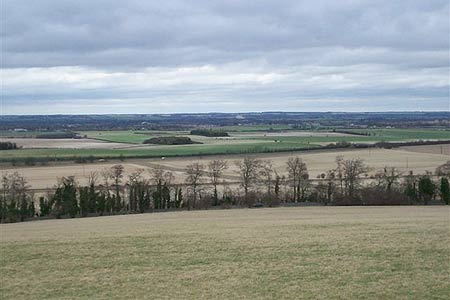
Close to the county border between Hertfordshire and Cambridgeshire, Therfield Heath has a reasonable height advantage over the surrounding area, which results in some very nice panoramic views, particularly over to a somewhat flat South Cambridgeshire. The early part of this walk crosses the Heath to check out this scenery before heading off to explore some equally attractive, rural and remote Hertfordshire countryside.
From the free car parks at the Sports Centre alongside the Baldock Road (grid ref TL347405) head off in a west south west direction. You will gain height easily on an initially indistinct path that soon becomes a white chalk scar some thirty metres below the crown of the slope alongside the golf course. The route soon reaches the viewpoint with its interesting toposcope at grid ref 343 403, so pause here for some excellent views, particularly to the north and over into Cambridgeshire. Note the county boundary is easily identified here as it the line of the A505 dual carriageway, less than a kilometre away to the north.
Continue on from here with the path now veering to the left, to reach and cross the minor road with an adjacent small car park. Follow the path as it turns to the left and crosses the golf course to Church Hill and then swings back to the right again with a copper beech hedgerow alongside to your right and a narrow band of trees on your left. Continue along the Hertfordshire Way (that runs to the north of the Kings Ride) to reach Thrift Farm at the bottom of the hill at grid ref TL320391.
Turn south east away from the farm on the clear and now waymarked track and in the distance you will see the top of a water tower dominating the skyline at the village of Therfield. This is the general direction to aim for. The next section, part of Hertfordshire's longest footpath, The Hertfordshire Way, offers wide and unspoilt rural views all the way to the Therfield, with only a somewhat secluded rifle range to be passed on the way. Note If you are using the Explorer map, the rifle range appears to be located elsewhere alongside the walk. The map is incorrect regarding this
As you draw near the edge of the village, the path gets steeper and narrows as it passes through the trees at Slipes Wood and alongside a small pond, passed on your left, to come out at the road. A short, but possibly interesting addition to the walk can be by turning right at this point for a few metres and then left up the wide track to bring you alongside the water tower with a rather rare (for Hertfordshire) trig pillar in the far right hand corner of the compound. From here, simply retrace your steps to where you came out of the woods to reach the road, to continue the next section of the walk.
Turn left and go ahead at the crossroads into Mill Lane, with an impressive thatched cottage on the corner. Soon this minor road becomes a bridleway; turn left at the fork, which is also waymarked (grid ref TL339375) and head across country back down the slope, again on a distinct track. This is the Icknield Way Path, another long distance trail, with more excellent views opening up ahead of you. Occasionally to your right and with some good visibility about, you will also get a glimpse over into the county of Essex. All too soon though, after continuing in a northerly direction, steadily losing height, you'll reach the rugby fields alongside the car park at Therfield Heath and the end of this walk
How to get there Therfield Heath can be reached from the A505 at junction 9 of the A1M and head for Royston. At the second roundabout leave the A505 onto Baldock Road to arrive at Sports Centre and car parks on the right.
Other walks nearby
| Walk 1812 | Therfield to Royston & Reed Circular | easy/mod | 10.0 miles |
| Walk 1118 | Roe Green and Sandon from Therfield circular | easy/mod | 7.3 miles |
| Walk 2107 | Reed to Nuthampstead Circular | easy/mod | 7.3 miles |
| Walk 2220 | Hertfordshire Way from Nuthampstead to Great Hormead | easy/mod | 10.0 miles |
| Walk 1265 | Clothall & Roe Green | easy/mod | 7.3 miles |
| Walk 2243 | Mare Way & Wimpole Estate from Orwell | easy | 5.2 miles |
| Walk 3103 | Wimpole Park and Whaddon | easy/mod | 8.3 miles |
| Walk 1663 | Cottered Warren & Wakeley | easy | 6.4 miles |
| Walk 1503 | Weston & Clothall circular Weston | easy | 5.5 miles |
| Walk 1810 | Graveley and Warren's GreenWeston | easy/mod | 7.0 miles |
Recommended Books & eBooks
No suggestions for this area.Messaging & Social Media
Message Walking Britain and follow the latest news.

Mountain Weather
Stay safe on the mountains with detailed weather forecasts - for iOS devices or for Android devices.