Loch an Eilein & Rothiemurchus Forest from Loch Morlich
Cairngorms Walk
Nat Park - Cairngorms - Cairngorm North
County/Area - Highland
Author - Peter Smyly
Length - 10.0 miles / 16.3 km Ascent - 300 feet / 91 metres
Time - 5 hours 20 minutes Grade - easy/mod
Maps 

| Ordnance Survey Explorer OL57 | Sheet Map | 1:25k | BUY |
| Anquet OS Explorer OL57 | Digital Map | 1:25k | BUY |
| Ordnance Survey Landranger 36 | Sheet Map | 1:50k | BUY |
| Anquet OS Landranger 36 | Digital Map | 1:50k | BUY |
Walk Route Description
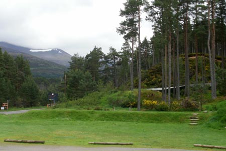
Click image to visit gallery of 7 images.
This is a good choice for a low level walk when the tops are affected by adverse weather conditions. Five lakes are passed during the walk including Loch an Eilein and Loch Morlich, two of the larger and better known lakes of the area. Paths and routes through the Rothiemurchus Forest are mostly clear, signposted and generally on the level or gentle up and down. There is some scope to vary the route as you go along, for example, if weather conditions change for the worse. Cyclists, as well as walkers, use the paths through the forest.
Start at the car park to the south of the Abhainn Ruigh-eunachan river to the east of Loch Morlich. The path through the forest heads due west initially. Glimpses of Loch Morlich can soon be seen through the trees to the right, though if you want a clear view of the lake, you need to leave the path temporarily as it does not run alongside the shore of the lake. The lake is popular with watersport enthusiasts and there is a beach to the east of it. At the western end of the lake, the path divides with the right turning going north-west to the road that passes the north of Loch Morlich. Go left here (south west) and within about five hundred yards, a small sheet of water, Lochan nan Geadas, appears between the trees on the left with a short path providing access. The lochan has one small tree-clad island and is home to some ducks. Continuing with the path in a generally south-westerly direction, you pass a path on the left that goes up to the Rothiemurchus Lodge. Take the path to the right signposted for Piccadilly and Coylumbridge. There are some glimpses of mountains as a backdrop to the forest with the conical peak of Carn Eilrig being seen to the south-west. The mountains either side of the Lairig Ghru valley are also seen. The next landmark to look out for is a river (Am Beanaidh) appearing on the left which keeps the path company for the next few hundred yards before it is time to cross it. The Cairngorm Club Footbridge enables the crossing to be made, the only bridge around for miles.
A little under a kilometre due west brings you to another lochan to the left of the path, Lochan Deo, a shallow little lake with reeds encroaching at the edge and stones seen on the bottom. Trees reflected in the water make for a good photo when the water is still. Evidence of timber-felling is seen soon after passing Lochan Deo with piles of logs and warning notices not to climb on them (correct at June 2011). In roughly the same distance again from Lochan Deo you catch sight of the next lake, a much bigger body of water, Loch an Eilein. The most notable feature of the lake is its island with a ruined castle on it. Follow the path along the north shore through the trees. At the north end of the lake is the Loch an Eilein Visitor Centre which has a shop that sells light refreshments, postcards and souvenirs and there are public conveniences nearby. At this juncture, you may decide to vary the return route by taking a bus back from Aviemore, in which case, you need to follow the path/road to the north.
This route suggests an anti-clockwise circuit of the lake, although views of the lake tend to be partially or wholly obscured by trees with only the occasional clear view of the lake. The area near to the Visitors Centre offers some of the clearest views of the lake. About a hundred yards or so after leaving the Visitors Centre, a short digression to the left through the trees offers a shoreline view of the island and this is the closest you will get to it from the shore, therefore if you want a clear photo of it, now is the time to take one. From a scenic point of view, this is be a good place to stop for a break, though, if you are doing this walk in summer, bear in mind that this is an attractive spot for midges which may cause you to move on again sooner rather than later. When the path reaches the south of Loch an Eilein, another smaller lake, Loch Gamhna, is seen to the right, the path crossing a stream that connects the two lakes. There are occasional fire brooms, with their long wooden handles and metal nets type ends, a reminder of the risk of forest fire. Next the path brings you back to the point where you reached the eastern end of Loch an Eilein earlier in the walk and it is time to start the route back to the east.
For the reverse route from Lochan an Eilein, the furthest point on the walk from the start point, there are three basic choices: 1) to reverse the outgoing route back to the car park, 2) to walk to Aviemore and take a bus or 3) to take a longer route back via the Rothiemurchus Lodge. If choosing option three, the return route will entail some road walking to get back to the car park. Note that length of the walk assumes you opt to take option 2 and return to the start using the bus from Aviemore. This distance also excludes a circuit of Loch an Eliein. If you take options 1 or 3 then the walk difficulty will rise to moderate to hard.
Other walks nearby
| Walk 2607 | Lairig Ghru & Chalamain Gap from Glenmore | mod/hard | 11.0 miles |
| Walk 3579 | Meall a'Bhuachaille & Ryvoan Bothy from Glenmore | moderate | 5.5 miles |
| Walk 3218 | Eag a' Chait gap Via Rothiemurchus Lodge from Glenmore | moderate | 8.2 miles |
| Walk 1020 | Glenmore to Linn of Dee via Lairig Ghru & Corrour | hard | 21.0 miles |
| Walk 2412 | Craiggowrie & Creagan Gorm from Loch Morlich | mod/hard | 7.3 miles |
| Walk 1904 | Loch Morlich circular (near Aviemore) | easy | 4.0 miles |
| Walk 2421 | Braeriach via the Chalamain Gap | hard | 15.0 miles |
| Walk 1881 | Ben Macdui & Cairn Lochan from the Ski Centre | hard | 10.4 miles |
| Walk 2672 | Cairngorm Mountain via Coire an t-Sneachda | mod/hard | 6.0 miles |
| Walk 1390 | Cairn Lochan via the Fiacaill Buttress from Ski Centre | very hard | 5.7 miles |
Recommended Books & eBooks
Great Mountain Days in Scotland
 Inspirational guidebook to 50 challenging routes for mountaineers, scramblers, hillwalkers and fell runners, many long enough to backpack over 2 days, especially in winter (12 to 25 miles). A mix of classic routes and unsung gems across Scotland from Galloway to the Outer Hebrides in widely differing wild landscapes. With customised OS mapping.
More information
Walking in Torridon
 This guidebook contains 52 day walks in Torridon, a remote and much-loved area of the Scottish Highlands. Based around Shieldaig and Slioch, the routes are split into 3 sections: easy walks, long and high level walks and mountain ascents over 2000ft including 9 Munros, and 5 outline suggestions for major ridge walks.
More information
Messaging & Social Media
Message Walking Britain and follow the latest news.

Mountain Weather
Stay safe on the mountains with detailed weather forecasts - for iOS devices or for Android devices.