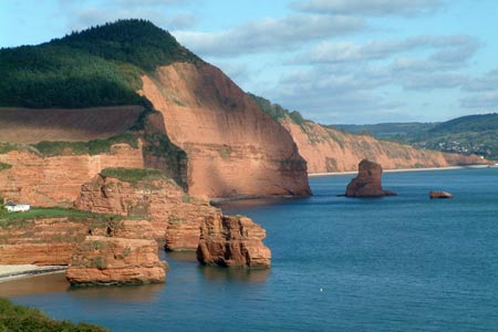
Danger Point & Ladram Bay from Otterton
Jurassic Coast Walk
Region - Jurassic Coast
County/Area - Devon
Author - Lou Johnson
Length - 6.0 miles / 9.8 km Ascent - 500 feet / 152 metres
Time - 3 hours 30 minutes Grade - easy/mod
Maps 

| Ordnance Survey Explorer 115 | Sheet Map | 1:25k | BUY |
| Anquet OS Explorer 115 | Digital Map | 1:25k | BUY |
| Ordnance Survey Landranger 192 | Sheet Map | 1:50k | BUY |
| Anquet OS Landranger 192 | Digital Map | 1:50k | BUY |
Walk Route Description
Click image to see photo description.
Starting from the village of Otterton, with its famous tearoom, the walk follows the banks of the River Otter towards the coast before turning northeast, using the South West Coast Path, along the sandstone cliffs typical of this part of Devon to Ladram Bay where there are a number of sandstone stacks.
The start is Otterton (grid ref. SY080852) where parking can be rather limited (see alternative start at the end of the description).Locate Fore Street and walk west crossing the bridge over the River Otter. Once over the river, turn left onto the footpath running south on the west bank of the River. Follow this path for just under one and a half miles until your reach a road a bridge over the river (grid ref. SY074830). Turn left over the bridge to the other side of the river and the right to follow the path. You are now on the South West Coast Path and this will be followed for the next section of the route.
Continue south to the mouth of the River Otter and the coast. The path turns north-east here and follows the cliff tops for about two miles passing a number of coastal features including Twopenny Loaf Rock! Reaching Chiselbury Bay, the coastal section is nearly complete and you should look out for the path junction (grid ref. SY094847) where you turn left to return to the centre of Otterton. However it is worth continuing along the coastal path for a few minutes to get a view over Ladram Bay with its wonderful rock stacks before returning to the path junction where you turn inland.
The path joins a track which leads to a lane (grid ref.SY089849). Turn left along the tarmac lane and then first right along Lea Lane (grid ref. SY0898470). Follow this track initially in a westerly direction before it turns sharp right and leads you into Otterton. Reaching the road with the interesting name of 'Behind Hayes', turn left into the centre of the village.
An alternative start is the car park at the east end of the seafront in Budleigh Salterton (grid ref. SY073819). From here take the South West Coast Path north along the River Otter to the bridge at grid ref. SY074830 mentioned in the description above. You can then follow the walk as described.
Other walks nearby
| Walk 2030 | Budleigh Salterton, East Devon | easy/mod | 7.0 miles |
| Walk 2279 | Salcombe Regis & Weston Mouth | easy/mod | 5.1 miles |
| Walk 1795 | Beer & Branscombe Circular | easy/mod | 5.5 miles |
| Walk 1550 | Charmouth & Lyme Regis Circular | easy/mod | 6.0 miles |
| Walk 2771 | Lyme Regis & Uplyme Circular | easy/mod | 5.5 miles |
| Walk 3311 | Trenchford & Tottiford Reservoirs (Moretonhampstead) | easy | 3.0 miles |
| Walk 1551 | Seatown and Charmouth via Golden Cap | easy/mod | 5.0 miles |
| Walk 2580 | Golden Cap & Charmouth | easy/mod | 5.0 miles |
| Walk 1323 | Broadsands Beach and Brixham | easy | 4.0 miles |
| Walk 1260 | Haytor Rocks & Hound Tor from Saddle Tor | moderate | 7.5 miles |
Recommended Books & eBooks
South West Coast Path Map Booklet - Minehead to St Ives
 Map of the northern section of the 630 mile (1014km) South West Coast Path National Trail. Covers the trail from Minehead to St Ives along the north Devon and Cornish coastline. This convenient and compact booklet of Ordnance Survey 1:25,000 maps shows the route, providing all of the mapping you need to walk the trail in either direction.
More information
The South West Coast Path
 Guidebook to walking the entire South West Coast Path National Trail. The route runs for 630 miles from Minehead to Poole along the north Devon, Cornish, south Devon and Dorset coastline. Divided into 45 stages, this long-distance coastal trek could be completed within 4 weeks, or walked in sections. Guide includes maps and essential information.
More information
Messaging & Social Media
Message Walking Britain and follow the latest news.

Mountain Weather
Stay safe on the mountains with detailed weather forecasts - for iOS devices or for Android devices.