Walk 1638 - printer friendly version
Beachy Head & Eastbourne Walk
Author - Lou Johnson
Length - 6.2 miles / 10.1 km
Ascent - 900 feet / 273 metres
Grade - easy/mod
Start - OS grid reference TV558978
Lat 50.7588860 + Long 0.2075843
Postcode BN20 0DL (approx. location only)
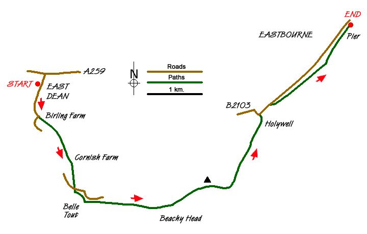
This linear walk in the South Downs National Park explores a wonderful section of the East Sussex coast including Belle Tout lighthouse, Birling Gap and the spectacular cliffs at Beachy Head. The route uses sections of the South Downs Way and ends in Eastbourne. A relatively frequent bus service from Eastbourne is a convenient way of returning to the start.
The walk starts at the free car park in the middle of East Dean village (Grid ref. TV558978). You can also use the no. 12 bus service that runs between Brighton and Eastbourne fairly frequently and walk to the car park from the bus stop on the main road.
Exit the car park and walk south along Gilbert's Drive towards the coast. Just before this road bends sharp right, continue ahead onto the signed bridleway. This leads past Birling Farm on your right. Ignore the first bridleway on your left and continue to the next junction of bridleways (grid ref. TV559969) where you go right. Continue past Cornish Farm walking almost due south to reach a road (grid ref. TV564956). Cross the road to a junction of paths. Turn left. Belle Tout Lighthouse is on your right as the path follows the road to reach the cliff tops.
Turn left along the South Downs Way National Trail, with the sea to your right. This well used path is followed to Beachy Head where there are some wonderful views down to the lighthouse and along the high chalk cliffs. After enjoying the view continue along the clear path until you are near the trig point on your left. This route leaves the South Downs Way here and turns right onto the Weald Way. The path descends quite steeply towards the coast with path returning to the cliff top until you reach the outskirts of Eastbourne at Holywell.
The path joins the B2103 and South Downs Way (grid ref. TV600971). Turn right along the B2103 for approximately 250 metres until you can veer right and down to the seafront once again. You can now enjoy a leisurely stroll along the promenade continuing as far as Eastbourne Pier. All that remains is to catch the bus back to the start.
Messaging & Social Media
Message Walking Britain and follow the latest news.

Mountain Weather
Stay safe on the mountains with detailed weather forecasts - for iOS devices or for Android devices.