Kinver Stroll
Staffordshire Walk
County/Area - Staffordshire
Author - John Roberts
Length - 2.0 miles / 3.3 km Ascent - 50 feet / 15 metres
Time - 1 hours 0 minutes Grade - easy
Maps 

| Ordnance Survey Explorer 218 | Sheet Map | 1:25k | BUY |
| Anquet OS Explorer 218 | Digital Map | 1:25k | BUY |
| Ordnance Survey Landranger 138 | Sheet Map | 1:50k | BUY |
| Anquet OS Landranger 138 | Digital Map | 1:50k | BUY |
Walk Route Description
Click image to see photo description.
WHERE - Off A458, 4 miles west of Stourbridge. Maps: Landranger 138, Explorer 218. Map reference SO840835.
TRANSPORT, PARK & START - Buses call; enquiries 0121 200 2700. There are several car parks off the High Street. Both the Stroll and the Walk start from Ye Olde White Hart Inn.
REFRESHMENTS - In the centre are the George & Dragon (Ansells), The Vine (Free House), Olde White Hart (Banks), Plough and Harrow (Batham's), several restaurants and a tea shop.
HOW FAR - Stroll 2 miles/3.25 kms, Walk 6 miles/9.5 kms.
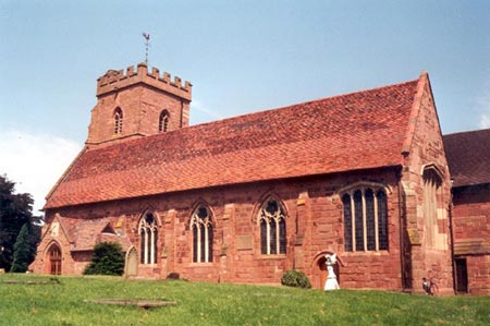
THE VILLAGE - Kinver originally grew up around St Peter's church, high on a sandstone hill above the flood plain of the River Stour. The present building is mainly 14th century but the earliest parts are Norman. Today the village sprawls along its several roads, but the High Street with its timber framed and brick buildings provides a focus. The village is hemmed in by the bulk of Kinver Edge to the south with the River Stour and the Staffs & Worcs Canal curling round to the east.
Kinver had its industrial revolution between 1820 and 1870. The river Stour was the source of power and from 1772 the canal provided transport. During the 19th century there were five iron mills around the village. Kinver Mill by the lock was powered by three waterwheels and produced iron and steel wire. Kinver Light Railway opened in 1901 from Amblecote near Stourbridge; Black Country workers on days off and Victorian tourists flocked to the area.
Mighty, sandstone Kinver Edge with its caves and hollows and acres of woodland belongs to the National Trust and Hereford and Worcester County Council, who call their bit Kingsford Country Park. From the summit are misty, blue views to the Clent Hills, The Sheepwalks, the Clee Hills, Abberley Hills and Malvems. The ridge is the meeting place of three long distance paths, the Staffordshire Way, Worcestershire Way and North Worcestershire Path.
Cave dwellings carved out of the rosy sandstone at Holy Austin Rock were occupied by hermits in the Middle Ages. During the 1800's, twelve families lived in houses which were later equipped with gas and a piped water supply, and some houses were inhabited until the 1950's. One of the Victorian cottages on top of the outcrop has been restored and is occupied by a warden.
THE STROLL - About level 2 miles beside the river Stour and the Staffordshire & Worcestershire Canal.
(1) Face 0lde White Hart & go R 500yds (past Police Station) to Mill House. Fork R, pass British Legion & bear R past Community Centre to playing fields.
(2) Bear R & follow R hedge. Go ahead 1/2 mile, via gates & fenced paths, to meet track. Go R over vehicle bridge & on 250 yds to canal
(3) Go R 1/2 mile, past Hyde Lock & round L bend to Kinver Lock. Leave towpath & follow road R back to start.
This walk is reproduced by kind permission of the publishers Walkways and is featured in the book "Strolls and Walks from Midland Villages" by Irene Boston & John Roberts. Visit his website for more information and online purchase.
Other walks nearby
| Walk 3003 | Kinver Edge & Blakeshall from Holy Austin Rock | easy | 4.3 miles |
| Walk 2834 | Kinver Edge circular | easy | 4.2 miles |
| Walk 3241 | Kinver Edge & Holy Austin Rock | easy | 2.6 miles |
| Walk 2874 | Enville Estate and the Sheepwalks | easy | 4.0 miles |
| Walk 1603 | Shatterford Wood and Castle Hill circular | easy/mod | 5.5 miles |
| Walk 2700 | Yieldingtree from Churchill | easy | 5.5 miles |
| Walk 1934 | Highgate Common and Surrounding Country | easy | 6.0 miles |
| Walk 2466 | The Severn Valley from Trimpley Reservoir | easy | 6.0 miles |
| Walk 1933 | Wyre Forest & River Severn from Upper Arley | easy/mod | 7.6 miles |
| Walk 2092 | Highley from the Severn Valley Country Park | easy/mod | 4.5 miles |
Recommended Books & eBooks
Walking in the Peak District - White Peak East
 Guidebook describing 42 half-day and day walks in the limestone landscapes of Derbyshire's White Peak, part of the Peak District National Park. One of two volumes, this book covers the east of the region, with potential bases including Bakewell, Eyam, Castleton, Birchover, Matlock and Wirksworth.
More information
Messaging & Social Media
Message Walking Britain and follow the latest news.

Mountain Weather
Stay safe on the mountains with detailed weather forecasts - for iOS devices or for Android devices.