Walk 1833 - printer friendly version
Great Gaddesden from Jockey End Walk
Author - Lou Johnson
Length - 5.2 miles / 8.5 km
Ascent - 300 feet / 91 metres
Grade - easy
Start - OS grid reference TL039137
Lat 51.8122870 + Long -0.4942408
Postcode HP2 6JD (approx. location only)
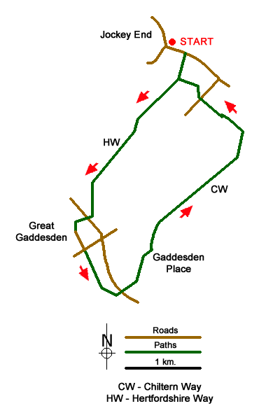
This Hertfordshire walk explores the pleasant countryside to the south east of Jockey End and follows the Hertfordshire Way to descend into the Gade Valley and the village of Great Gaddesden. The return route leaves the valley following the Chiltern Way for the return to the start.
Parking is available in the Garden Centre overspill car park (grid ref. TL039137). Please do not park on the street as many residents have been suffering from inconsiderate parking, inconvenience and abuse. After parking walk east from the road junction in the centre of the village. After 250 metres take the signed footpath on your right to follow the Hertfordshire Way across field to the Hoo, which will be on your left. Continue along the Hertfordshire Way to pass Hoo Wood, which will be on your right. A short section of the path is through this wood before reaching open fields and a descent down to the A4146. Cross this main road with care and take the footpath opposite. This leads across a footbridge over the River Gade before turning south to reach the main street of Great Gaddesden along a tarmac lane lined with houses.
Cross the main street through the village and take the signed footpath almost immediately opposite. This leads past the old watercress beds along the River Gade on your left. Reaching a junction of paths (grid ref. TL032107), bear half left, cross the footbridge, join the Chiltern Way and reach the A4146 once again. Take care crossing the road and continue by taking the footpath opposite. The way ahead climbs out of the Gade Valley, passes Gaddesden Place on your right, to reach a wide path/track (grid ref. TL038112). Turn left here and follow the Chiltern Way to follow a route that loops to the west of Home Farm to join a clear track northeast in the direction of Golden Parsonage. Before reaching the latter the path veers half left and before turning north-west to The Lane House and a junction of paths (grid ref. TL048128).
The Chiltern Way turns right here but we initially turn left and then right again to follow the path across fields to a lane (grid ref. TL044131). Cross this lane and continue in the same direction across fields to reach the Hertfordshire Way used for the outward section of the walk. Turn right along this long distance path and continue to reach the road. Turn left and the centre of Jockey End is a short walk away.
Messaging & Social Media
Message Walking Britain and follow the latest news.

Mountain Weather
Stay safe on the mountains with detailed weather forecasts - for iOS devices or for Android devices.