Lastingham & Rosedale from Hutton-le-Hole
North York Moors Walk
Nat Park - North York Moors - North York Moors West
County/Area - North Yorkshire
Author - Barry Jenkinson
Length - 12.0 miles / 19.5 km Ascent - 900 feet / 273 metres
Time - 6 hours 50 minutes Grade - moderate
Maps 

| Ordnance Survey Explorer OL26 | Sheet Map | 1:25k | BUY |
| Anquet OS Explorer OL26 | Digital Map | 1:25k | BUY |
| Ordnance Survey Landranger 100 | Sheet Map | 1:50k | BUY |
| Anquet OS Landranger 100 | Digital Map | 1:50k | BUY |
Walk Route Description
Click image to visit gallery of 3 images.
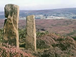
This North York Moors walk starts in the village of Hutton-le-Hole and includes a mixture of arable farm land and wild moorland. In addition the route also visits several moorland crosses and you can also visit a 14th century crypt at Lastingham.
Hutton-le-Hole is a picturesque moorland village with sheep roaming freely on the village green, which is surrounded by stone built cottages. The village is home to the Ryedale Folk Museum which is well worth a visit. Parking is available at the North end of the village in a fee paying car park.
After parking, walk back into the village past the Ryedale Folk Museum and the church on you left. Opposite the village hall turn left along a signposted footpath and proceed across fields of sheep with the museum grounds on your left. Carry straight on for about 3/4 mile over stiles and across a small bridge before climbing the hill towards Lastingham.
When you reach the road, turn right along it and stick to the road (very few cars) until the road takes a sharp right after about half a mile. You turn left down a cart track and follow signed footpaths around the farm and down into a steep valley and up the other side.
On reaching the top you will see a bench on your left and a signpost to Rosedale. If you want to have a long walk take this one and follow it straight into Rosedale down the 1 in 3 hill. From here the way back is by a quiet moorland road to Hutton-le-Hole up Chimney Bank.
If you require a shorter walk (5 miles) turn right and walk down into Lastingham village. There is a fine pub for a lunch stop and opposite is the old church of St Cedds, with its 14th century crypt. Walk back via Spaunton and once through the village turn right at a T-junction then go left through Grange Farm. Follow way marked paths through fields until you drop back into Hutton-le-Hole, just south of Moorlands, where you turn right into the village.
Other walks nearby
| Walk 3398 | Rollgate Bank & Aumery Park from Fadmoor | moderate | 11.0 miles |
| Walk 1921 | Spaunton Moor from Chimney Bank | easy/mod | 8.1 miles |
| Walk 2665 | Cawthorne Roman Camp Circular | moderate | 12.2 miles |
| Walk 1542 | The Rudland Ridge from Ousegill Bridge | moderate | 10.1 miles |
| Walk 1527 | Farndale Circular from Little Blakey | moderate | 12.0 miles |
| Walk 1674 | Rosedale Valley circular from Little Blakey | moderate | 11.0 miles |
| Walk 1920 | Rievaulx Moor from Cowhouse Bank | moderate | 9.5 miles |
| Walk 2077 | Glaisdale Moor circular | moderate | 11.9 miles |
| Walk 1397 | Hole of Horcum from Levisham Station | easy/mod | 8.5 miles |
| Walk 1525 | Beck Dale & Rievaulx from Helmsley | moderate | 9.8 miles |
Recommended Books & eBooks
Trail and Fell Running in the Yorkshire Dales
 Guidebook to 40 of the best trail and fell runs in the Yorkshire Dales National Park. Ranging from 5 to 24 miles, the graded runs start from bases such as Ribblehead, Dent, Sedbergh, Malham and Grassington and take in the region's diverse delights, from castles and waterfalls to iconic mountains such as Whernside, Ingleborough and Pen Y Ghent.
More information
Messaging & Social Media
Message Walking Britain and follow the latest news.

Mountain Weather
Stay safe on the mountains with detailed weather forecasts - for iOS devices or for Android devices.