Ivinghoe Beacon and Bridgewater Monument from Tring
Chilterns Walk
Region - Chilterns
County/Area - Hertfordshire & Buckinghamshire
Author - Barry Mackie
Length - 8.0 miles / 13 km Ascent - 1200 feet / 364 metres
Time - 5 hours 10 minutes Grade - easy/mod
Maps 

| Ordnance Survey Explorer 181 | Sheet Map | 1:25k | BUY |
| Anquet OS Explorer 181 | Digital Map | 1:25k | BUY |
| Ordnance Survey Landranger 165 | Sheet Map | 1:50k | BUY |
| Anquet OS Landranger 165 | Digital Map | 1:50k | BUY |
| Ordnance Survey Landranger 166 | Sheet Map | 1:50k | BUY |
| Anquet OS Landranger 166 | Digital Map | 1:50k | BUY |
Walk Route Description
Click image to visit gallery of 11 images.
This circular walk in Hertfordshire starts and finishes at the car park adjacent to the railway station in the Hertfordshire town of Tring. The location makes this a perfect opportunity for both commuters out of London and also for anyone else who wishes to leave the car at home, to explore some of the Chiltern Hills. The outward section follows the Ridgeway, which is one of the National Trails and might just be Britain's oldest path, as it leads you over one of the most spectacular parts of the Chilterns. On the way back, you will retrace your steps to have another look at some of the fabulous scenery seen earlier and then continues through ancient woodlands to visit the Bridgewater Monument and Pitstone Common. Most of the walk is set within The Chiltern Hills Area of Outstanding Natural Beauty (AONB) and the Ashridge Estate, a National Trust property. As befits a national trail, the Ridgeway is extremely well signposted and the symbol to look out for is an acorn.
A word of caution before you set off though; much of the Ridgeway has been left in its natural state underfoot and therefore some sections can get a bit muddy. So either come prepared or choose your day according to the local weather.
From the car park entrance (Grid ref. SP951122), turn right along the road and go past the T-junction to reach a Ridgeway waymarker that directs you up the concrete track alongside a field on your left (Grid ref. SP953123). Continue on this direction for a short distance to reach a wooden gate and then turn left along the path through the woods, passing the Butterfly Nature Reserve on your left and into the area known as Albury Nowers. There is one fairly steep part on this section, but wooden steps have been cut into the path, ensuring that it will represent no significant problems whatever the conditions underfoot.
Soon the trees start to thin on your left and the wide views begin to open up westward over of the Vale of Aylesbury and this just gets better and better as you reach the open ground at Pitstone Hill, where you get a first sight of Ivinghoe Beacon in the distance, to the north- northeast. It is at Pitstone Hill that you first notice the deep scar in the hillside. This is Grim's Ditch, which possibly dates from the Iron Age and was likely to have been a district or agricultural boundary. Follow the waymarkers that direct you around the summit of the next hill and gradually losing height, you'll then reach the lower end of the grassed picnic area by the road (Grid ref. SP955148). Turn left and go along the road for a few metres and then opposite the car park continue in a Northeast direction across the grassed fields.
This part of the walk is fairly level until you start to gain height to reach the upper slopes of Steps Hill by skirting Incombe Hole on your left. This wonderful combination of "high and low" makes for a very impressive sight as you look both over and down at it. This has to be one of the finest views in this part of the county, and all for such little effort! Move on from this delightful spot in a generally northern direction to soon reach and then take the narrow path through the light woodland and gorse area. As you exit the far side onto open land and then down to the road, there is now only the final and fairly easy ascent of Ivinghoe Beacon in front of you.
On the summit of the Beacon (233m/765ft), it is as you would expect with superb views in every direction, but wait a minute! Those to the east over Gallows Hill and beyond to the White Lion etched into the chalk hillside on the Dunstable Downs some 2.5 miles away. Those are views with some difference!
Leave the summit and retrace your steps back to Incombe Hole and the point where the Ridgeway veers to the right and down the slope (Grid ref. SP961155). Here take the path that forks left up the slope and through the woods to come out at the road.
Note As an alternative you could just go left up the road from the foot of the Beacon and maybe stop at the ice cream van in one of the car parks. But another look at Incombe Hole, Steps Hill and the panoramic views seen earlier is an opportunity not to be missed.
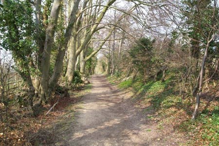
Upon reaching the road, turn right immediately to take the wide well made track and walk towards Clipper Down, which is both signposted on the gate and marked on the OS Explorer map. Slightly odd, but it is only some distance later along this path, when you go over the cattle grid and then look back that you will see a sign informing that you have just left the Ivinghoe Hills Nature Reserve! This part of the walk is as pleasant a woodland stroll as it gets, with predominantly mature and ancient beech trees. The walk remains like this almost until you reach the village of Albury.
At the cottage at Clipper Down (Grid ref. SP965147) go through the gate on the right side which has a handy sign on it directing you initially to the east and then veering south on the wide track through Duncombe Terrace and Moneybury Hill to reach the monument at the open area at Pitstone Common. Arriving here; The Bridgewater Monument, at 106ft high, is a spectacular sight as it dominates its surroundings. The monument was built to celebrate the life and achievements of the 3rd Earl, who is described on its base as "The Father of Inland Navigation".
Details on how to get to the top of the monument are to be seen at the entrance, but sadly there was nobody around to let us in. As a result we only saw the distant views along Prince's Riding to the east from ground level. There is plenty to do here if you want to stop for a break. Close by, there are parking and picnic areas, a Visitor Centre, a café and toilets. Leave this area heading south on the continuation of the route you entered by and take the right fork at grid ref. SP968127 to come out at Toms Hill Road. Turn right to reach the centre of the village of Aldbury.
Go past the pond and the church, both on your right, and turn right onto the footpath alongside the right hand side of Church Farm and soon after turn left again at grid ref SP958127 along the narrow path by the golf course. Follow this path in a southwest direction to regain the Ridgeway and then onto the concrete track alongside the edge of the field that we used near the start of the walk. Turn right at the road and a few minutes later you are back at the station cat park and the finish of this walk.
Tring is a mainline station out of London Euston. If you're travelling by car, the town is easily accessed off the A41 and parking at the station is £ 5 per day, but free on Sundays and Bank Holidays (2007 prices).
Other walks nearby
| Walk 3025 | Ashridge Estate Circular | easy | 4.5 miles |
| Walk 1999 | The Chilterns above Tring | moderate | 12.0 miles |
| Walk 2399 | The Chilterns above Tring (short version) | easy/mod | 8.0 miles |
| Walk 2064 | Ivinghoe Beacon from the Ashridge Estate | easy/mod | 6.5 miles |
| Walk 1007 | The Ashridge Estate circular | easy/mod | 6.0 miles |
| Walk 3098 | Tring & Wendover Woods | easy/mod | 7.5 miles |
| Walk 3503 | Circular from Berkhamsted | easy | 4.0 miles |
| Walk 1297 | Berkhamsted and Northchurch Commons | easy | 5.0 miles |
| Walk 1399 | Berkhamsted & Northchurch Commons | easy | 5.5 miles |
| Walk 3360 | Cholesbury Camp and Hawridge | easy | 4.4 miles |
Recommended Books & eBooks
No suggestions for this area.Messaging & Social Media
Message Walking Britain and follow the latest news.

Mountain Weather
Stay safe on the mountains with detailed weather forecasts - for iOS devices or for Android devices.