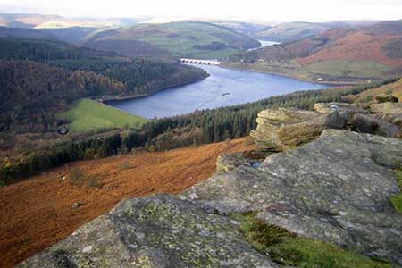
Bamford & Stanage Edges from Rod Side
Peak District Walk
Nat Park - Peak District - Gritstone Edges Higger Tor
County/Area - South Yorkshire & Derbyshire
Author - Andy Chaplin
Length - 9.9 miles / 16.1 km Ascent - 1240 feet / 376 metres
Time - 6 hours 10 minutes Grade - moderate
Maps 

| Ordnance Survey Explorer Ol1 | Sheet Map | 1:25k | BUY |
| Anquet OS Explorer Ol1 | Digital Map | 1:25k | BUY |
| Ordnance Survey Landranger 110 | Sheet Map | 1:50k | BUY |
| Anquet OS Landranger 110 | Digital Map | 1:50k | BUY |
Walk Route Description
Click image to visit gallery of 3 images.
This Peak District walk starts on the edges of South Yorkshire at grid reference SK242883 on the minor road, Rod Side, above Hollow Meadows where there is enough off-road parking for half a dozen cars. The walk takes in the Bamford and Stanage edges giving great views towards Ladybower and the Derwent valley above Bamford. By starting above the A57 it also ensures that there is no walking along the main road. A shorter alternative would be to start in the Cutthroat Bridge layby or the parking on Long Causeway below Stanage Edge.
From the parking on Rod Side road above Hollow Meadows take the Heathy Lane track towards and past Moscar Cross Farm then turn right on Moscar Cross Road track and follow it around to the left as it makes its way across fields and down to Sugworth Road. Go left on the road and at the junction with Mortimer Road go straight across and take the path to Moscar House. Pass straight through the yard and continue on the path which leads on to the A57 at Cutthroat Bridge.
Cross the A57, go over the stile then continue up the track that leads up the side of Jarvis Clough. After just over half a mile, and before the track bends to the left, there is a path off on the right that passes a lone tree, goes over the Jarvis Clough then climbs up the far side. The path is easy to follow, although it is not marked on OS maps, and picks up the line of the wall at the start of Bamford Edge.
As you start to walk southwards you pass two stone pillars then there are several paths. The rule is stay close to the edge but do not lose height and aim to go through the next wall at grid reference SK206857. From here the path is better defined along the edge. Continue along the edge until the rocks on your right run out, the path straight ahead starts to descend and there is a path off on the left at SK213846. Go left over the rise, follow the path south east and then go around the north and east of the old quarry. When you come out at the bottom take the path to the right. This comes out at a stile. The path to the left comes out further up the road but you have to step over a (non-barbed) wire fence.
Reaching the road (grid ref. SK215839), turn left and follow it for just over 2 km. passing Bole Hill on your left and Dennis Knoll wood on your right. Continue over the cattle-grid, pass the small car park on your right and continue along what is now a track past a small plantation also on your right. At the end of the plantation look out for a footpath on your left (grid ref SK228847). This path climbs steadily uphill onto Stanage Edge. Reaching the well-worn path along the edge, turn left and continue initially north-west and then north.
The walk back along Stanage Edge gives similar views towards Ladybower but it is no longer possible to see into the Derwent valley. The path is well defined, in fact well-worn, and the only complication is looking out for the slight turn north then north-east to come off the edge and take the track down to the A57. Cross straight over, walk past Moscar Lodge on Heathy Lane then go right and take the paths back to the parking on Rod Side.
Other walks nearby
| Walk 2516 | Moscar, Dale Dike & Shrines Reservoirs | easy/mod | 7.0 miles |
| Walk 2629 | Stanage Edge, Redmires & Hallam Moors | easy/mod | 8.5 miles |
| Walk 3540 | The Derwent Edge from Cutthroat Bridge | moderate | 10.0 miles |
| Walk 1541 | Redmire, Stanage & Ughill Moor circular | moderate | 13.0 miles |
| Walk 1580 | Redmires Reservoir | easy | 2.5 miles |
| Walk 1578 | Dale Dike Reservoir | easy | 2.5 miles |
| Walk 1285 | Dungworth & Rod Moor | moderate | 9.4 miles |
| Walk 1577 | Low Bradwell & Agden Reservoir | easy | 3.5 miles |
| Walk 1754 | Agden Reservoir Circular | easy/mod | 4.8 miles |
| Walk 1090 | Stanage Edge | moderate | 7.0 miles |
Recommended Books & eBooks
Walking in the Peak District - White Peak East
 Guidebook describing 42 half-day and day walks in the limestone landscapes of Derbyshire's White Peak, part of the Peak District National Park. One of two volumes, this book covers the east of the region, with potential bases including Bakewell, Eyam, Castleton, Birchover, Matlock and Wirksworth.
More information
Great Mountain Days in the Pennines
 An inspirational guidebook to 50 classic walks on the rolling Pennine landscape. The graded routes, between 6 and 13 miles in length, cover classic Pennine fells and moorland such as Whernside, Ilkley Moor and Pendle Hill; exploring the North and South Pennines, Yorkshire Dales, Howgills and Dark Peak. Many routes are also suited to fell running.
More information
Messaging & Social Media
Message Walking Britain and follow the latest news.

Mountain Weather
Stay safe on the mountains with detailed weather forecasts - for iOS devices or for Android devices.