Pound Green and Dowles Brook from Hawkbatch
Shropshire Walk
County/Area - Shropshire & Worcestershire
Author - Peter Lane
Length - 5.0 miles / 8.1 km Ascent - 650 feet / 197 metres
Time - 3 hours 10 minutes Grade - easy
Maps 

| Ordnance Survey Explorer 218 | Sheet Map | 1:25k | BUY |
| Anquet OS Explorer 218 | Digital Map | 1:25k | BUY |
| Ordnance Survey Landranger 138 | Sheet Map | 1:50k | BUY |
| Anquet OS Landranger 138 | Digital Map | 1:50k | BUY |
Walk Route Description
Click image to visit gallery of 3 images.
The Wyre Forest with its Visitor Centre at Callow Hill and free car park at Hawkbatch offer easy guided walks via coloured posts to those with less time or inclination to strike out on their own initiative. This walk starts at Hawkbatch, but ignoring coloured posts goes through dense forest. A map and compass are essential.
Park at the Forestry Commission car park at Hawkbatch SO761776. Near the entrance to the car park, just inside the turning, there is a public footpath. Follow this (turn left at the first fork in the path) to a stile and an open field. There are superb views of the Forest from here. Follow the hedge on the right to Woodhouse Farm and then take the driveway all the way to the road. Turn right towards Pound Green village and immediately left at the Community notice board. The onward path is to the left of the houses, continues for a short distance as a narrow track and then opens up into Pound Green Coppice.
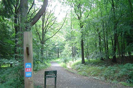
Take a bearing of about 255 degrees and follow the obvious path ignoring all intersecting paths. Emerge near the main road at a stile leading through some poor fellow's back garden and then onto the road. Cross over and follow the Cycle Route 45 sign into the Forest. This path then intersects the main Forestry track at a signpost. Follow the road to the Callow Hill Visitor Centre for about 40 yards and then turn right down a long straight fire-break. This is the path of the Elan Valley pipeline from Rhyader to Birmingham. It is interspersed with mini brick access structures.
The next bridlepath to the left can be missed easily, especially when the ferns obscure the waymark. Turn downhill, meeting up with walk 2248 at a 90 degree left hand bend. Follow round to the left (doing Walk 2248 in reverse for some distance) until reaching another 90 degree left hand turn after which you turn downhill to the right along a path wire-fenced on both sides. At the end of this path turn right down to a brook, cross and ascend up the muddy bank coming to a cross-roads of paths. Take the bridlepath to the left and follow until reaching another major Forestry road.
Depart from walk 2248 here, turning left and descending down to a major Forestry cross-roads with the number 45 Cycle Route. Here is a good spot to sit down and enjoy the view (but there's a better one in less than half a mile). Follow the sign to Dowles Brook, coming to another bench by a footbridge. Cross into Worcestershire and follow this delightful path keeping the Brook always close by. Coming to a beautiful, secluded ford; cross and come shortly to a footbridge returning you to Shropshire. Turn right at the Nature Reserve sign and pass Cooper's Mill Youth Centre.
At a fork in the path, ignore the minor path on the right that continues along the brook. Turn left, climb steadily uphill passing a hide to the left and onwards along an improving path, ignoring lesser paths. Soon the noises of civilisation can be heard again as you approach the road. When you see a gate at the road in the distance, head slightly right along the small footpath leading to a signpost just inside the hedge next to the road. Turn right here, a path runs parallel to the road. At a gap in the hedge, emerge at the side of the road, cross and return to Hawkbatch car park
Other walks nearby
| Walk 2131 | Wyre Forest National Nature Reserve, Bewdley | easy | 3.3 miles |
| Walk 2466 | The Severn Valley from Trimpley Reservoir | easy | 6.0 miles |
| Walk 1933 | Wyre Forest & River Severn from Upper Arley | easy/mod | 7.6 miles |
| Walk 2248 | Wimperhill Wood and Longdon Orchard, Wyre Forest | easy | 4.0 miles |
| Walk 3217 | Bewdley and Snuffmill Dingle | easy | 5.0 miles |
| Walk 3504 | Highley to Bewdley along the River Severn | easy/mod | 7.0 miles |
| Walk 1603 | Shatterford Wood and Castle Hill circular | easy/mod | 5.5 miles |
| Walk 2092 | Highley from the Severn Valley Country Park | easy/mod | 4.5 miles |
| Walk 2807 | The River Severn from Hampton Loade to Bridgnorth | easy/mod | 6.0 miles |
| Walk 2874 | Enville Estate and the Sheepwalks | easy | 4.0 miles |
Recommended Books & eBooks
Hillwalking in Shropshire
 Guidebook to 32 walking routes in Shropshire in the West Midlands. The routes range from 3 miles (5km) to 12 miles (19km), taking in highlights such as The Wrekin, Wenlock Edge, Long Mynd and Stiperstones, Castle Ring and Bury Ditches. Many routes start near delightful towns and villages including Church Stretton, Ludlow and Bishops Castle.
More information
Messaging & Social Media
Message Walking Britain and follow the latest news.

Mountain Weather
Stay safe on the mountains with detailed weather forecasts - for iOS devices or for Android devices.