Higher Pertwood & Wessex Ridgeway from Hindon
Wiltshire Walk
County/Area - Wiltshire
Author - Lou Johnson
Length - 8.1 miles / 13.2 km Ascent - 800 feet / 242 metres
Time - 4 hours 50 minutes Grade - easy/mod
Maps 

| Ordnance Survey Explorer 118 | Sheet Map | 1:25k | BUY |
| Anquet OS Explorer 118 | Digital Map | 1:25k | BUY |
| Ordnance Survey Landranger 184 | Sheet Map | 1:50k | BUY |
| Anquet OS Landranger 184 | Digital Map | 1:50k | BUY |
Walk Route Description
Click image to see photo description.
This walk explores the pleasant rolling countryside and woodland to the north of the village of Hindon. Parking on the street is available in the centre of the village (grid ref. ST911328) but please do be considerate and ensure you not causing obstructions for local residents.
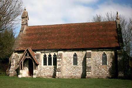
After parking walk north-west up High Street. Continue straight across the B3089 and walk along the quiet lane into the countryside passing the entrance driveway to Hawking Down on your right. After a further 300 metres take the track that goes off on the right. This leads in a more northerly direction to the A303. Particular care is need crossing this busy road. Once across continue on the track directly opposite with buildings to your right and a small copse to your left. Continue along this track for 400 metres to take the path going half left towards woodland with a prominent radio mast. The path enters the wood (grid ref. ST896350) for a short distance before entering a field. Go half left across this field to re-enter woodland. Exit the wood and continue in a north-westerly direction towards the hamlet of Higher Pertwood with its rather pretty disused chapel.
Continue ahead along the lane passing the chapel on your left to reach a junction of footpaths and bridleway with the lane (grid ref. ST887359). Turn sharp right here following a track along the field edge (hedge to your right). Continue to the end of the field to reach a further track (grid ref. ST897364). Turn right and then almost immediately left onto a bridleway flanked by trees and bushes. This leads southwest to another junction of tracks (grid ref. ST904360). Go left here (north) with the edge of the wood to your right and continue on a clear track for 200 metres to turn right on a clear track into the woods. Follow this track for a mile to reach the point where the Wessex Ridgeway meets this track (grid ref. ST921363). Turn right here following the Wessex Ridgeway south. After just over 100 metres (grid ref. ST021362) go left and follow the grassy track for about 600 metres to a track (grid ref. ST927361). Turn right here down to a T-junction. Turn left and follow for 400 metres until the track bears right. Continue ahead here, leaving the track, on a grassy path down the valley to reach the A303.
Cross with care and turn right alongside the main road for 300 metres. Turn left onto the Wessex Ridgeway south. This leads you along a track which is followed for 600 metres where you bear left to leave the track to follow the Wessex Ridgeway southwest to meet a lane (grid ref. ST912336). Bear left along the lane to take the footpath on your right after 400 metres to continue following the Wessex Ridgeway. This leads to another lane (grid ref. ST908330). Turn left down the lane and you will soon be back in the centre of Hindon.
Other walks nearby
| Walk 1748 | East Knoyle & Hindon from West Knoyle | moderate | 9.6 miles |
| Walk 3679 | Wardour Castle, Ansty Down & Wardour Park | easy/mod | 7.5 miles |
| Walk 2936 | Cold Kitchen Hill from Longbridge Deverill | easy/mod | 8.7 miles |
| Walk 3632 | Battlesbury Hill from Norton Bavant | easy/mod | 6.0 miles |
| Walk 2465 | Steeple Langford Circular | moderate | 9.8 miles |
| Walk 3626 | The Fovant Badges from Broad Chalke | easy/mod | 9.3 miles |
| Walk 2158 | Great Wishford & Grovely Lodge | easy/mod | 6.6 miles |
| Walk 3743 | Win Green from Tollard Royal | easy/mod | 5.4 miles |
| Walk 3237 | Bowerchalke & the Ox Drove | easy/mod | 8.0 miles |
| Walk 2171 | Knighton Hill & the Ox Drove | easy/mod | 5.8 miles |
Recommended Books & eBooks
The Kennet and Avon Canal
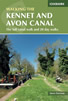 Guidebook to walking along the Kennet & Avon Canal. The 94 mile route from Reading to Bristol is split into 7 stages of fairly easy walking and includes the UNESCO World Heritage Site of Bath and Bristol's Floating Harbour. 20 circular walks are also included, ranging from 4¼ to 9 miles, taking in the best sections of the canal.
More information
Messaging & Social Media
Message Walking Britain and follow the latest news.

Mountain Weather
Stay safe on the mountains with detailed weather forecasts - for iOS devices or for Android devices.