Blea Tarn & Eskdale Green from Boot
Lake District Walk
Nat Park - Lake District - Lake District Southern Fells
County/Area - Cumbria
Author - Lou Johnson
Length - 6.5 miles / 10.6 km Ascent - 1100 feet / 333 metres
Time - 4 hours 20 minutes Grade - easy/mod
Maps 

| Ordnance Survey Explorer OL6 | Sheet Map | 1:25k | BUY |
| Anquet OS Explorer OL6 | Digital Map | 1:25k | BUY |
| Ordnance Survey Landranger 90 | Sheet Map | 1:50k | BUY |
| Anquet OS Landranger 90 | Digital Map | 1:50k | BUY |
Walk Route Description
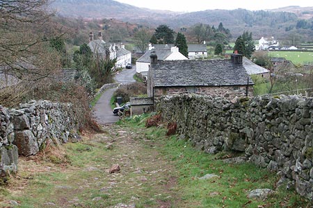
Click image to visit gallery of 9 images.
Eskdale is one of the quieter valleys in Lakeland. It offers some beautiful scenery with low fells set against a backdrop of high fells including the Scafells. This Lake District walk begins with a moderate ascent to Blea Tarn from the small village of Boot before continuing down the ridge of low fells towards Eskdale Green. The return is along the Esk valley and includes Gill Force waterfall.
Parking in the village of Boot is at a premium. However there is a large car park at the Ravenglass & Eskdale Railway station (Grid ref. NY172006) where a fee may be payable if you do not use the trains. However you can return from Eskdale Green by train omitting the valley walk as described. From the station, exit onto the main valley road and turn left. Walk along this road to Brook House where you go left into the village. At the end of the tarmac lane continue ahead on the signed bridleway climbing steadily across the fellside.
Reaching the open fellside (Grid ref. NY176017) go through the gate in the intake wall. Continue to follow the track and bear left at the first fork. This track continues for some way and used to service mine workings in the area. Eventually the track becomes a path and this followed to reach Blea Tarn, which is on your right. Continue around the shore to join the path coming up from Beckfoot and continue to reach Siney Tarn where care is needed to avoid the boggy areas.
After Siney Tarn, the path follows the northern edge of Sineytarn Moss before veering southwest to reach a wall. The path continues alongside this wall, which is on your left, to reach a gate in a fence. Go through the gate and take the higher path, which leads to the right of a derelict barn. Continue ahead on this path as you descend into Eskdale to cross the railway and reach the road (Grid ref. NY146998). If you are returning by train then turn right for Eskdale Green station otherwise go left along the road. Turn left at the road junction and then right down the path (Grid ref. NY152000) to the River Esk.
Cross the river and turn left along the bridleway. At first this follows the river but soon enters woodland. Passing Dalegarth Hall on your left you cross a footbridge (Grid ref. NY173001) over Stanley Gill to regain the banks of the Esk. Continue upstream to reach a bridge (Grid ref. NY176002). Cross this and follow the path alongside the river downstream towards the chapel. Turn right in front of the chapel along a track, bearing right at the first junction. At the next junction (Grid ref. NY175008) turn left along the lane back to the start.
Other walks nearby
| Walk 1299 | Green Crag | moderate | 6.5 miles |
| Walk 2361 | Scafell & Slight Side | hard | 9.5 miles |
| Walk 2362 | Scafell Pike and Scafell | very hard | 11.0 miles |
| Walk 2675 | Eel Tarn and Stony Tarn | easy/mod | 6.0 miles |
| Walk 2229 | Tarns of Eskdale | easy/mod | 7.5 miles |
| Walk 1932 | Slight Side from Whahouse Bridge | moderate | 5.6 miles |
| Walk 1668 | Silver Knott & Muncaster Fell from Irton Road | easy/mod | 5.0 miles |
| Walk 2226 | The Scafells | very hard | 12.0 miles |
| Walk 1916 | Harter Fell and Low Birker Tarn from Hardknott Pass | moderate | 6.5 miles |
| Walk 3419 | Scafell Pike an Eskdale circular | very hard | 12.5 miles |
Recommended Books & eBooks
Walking the Lake District Fells - Mardale and the Far East
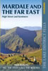 Part of the Walking the Lake District Fells series, this guidebook covers a wide range of routes to 36 Lakeland summits that can be climbed from the Ullswater, Haweswater, Troutbeck, Kentmere and Longsleddale valleys, with highlights including High Street, Place Fell and the Kentmere fells. Suggestions for longer ridge routes are also included.
More information
Great Mountain Days in the Lake District
 An inspirational guidebook to 50 challenging walks on the high fells of the Lake District. The graded circular routes, between 4 and 14 miles in length, cover classic Lakeland summits like Fairfield, Scafell Pike, Great Gable and Blencathra, to the lesser-known High Spy, King's How and Brund Fell.
More information
Messaging & Social Media
Message Walking Britain and follow the latest news.

Mountain Weather
Stay safe on the mountains with detailed weather forecasts - for iOS devices or for Android devices.