Ripon Rowel Walk Leg 2 - South Stainley to Sawley
North Yorkshire Walk
County/Area - North Yorkshire - Vale of York
Author - Phil Catterall
Length - 8.5 miles / 13.8 km Ascent - 1050 feet / 318 metres
Time - 5 hours 20 minutes Grade - easy/mod
Maps 

| Ordnance Survey Explorer 298 | Sheet Map | 1:25k | BUY |
| Anquet OS Explorer 298 | Digital Map | 1:25k | BUY |
| Ordnance Survey Landranger 99 | Sheet Map | 1:50k | BUY |
| Anquet OS Landranger 99 | Digital Map | 1:50k | BUY |
Walk Route Description
Click image to visit gallery of 3 images.
Continuing on the second leg of the 50 miles Ripon Rowel with a walk through Studley Park passing Markenfield Hall and Fountains Abbey. The route is well marked on OS Maps. This is a linear walk with car parking available at St.Wilfred's Church - if used please leave a contribution in the charity box at SE306631. The walk ends at Sawley where parking is available near the Village Hall at SE248678. If car sharing is not a possibility the taxi fare from Sawley back to South Stainley is approximately £ 16 (2008 prices). You may also travel via the regular 36 bus service from Harrogate or Ripon to South Stainley on the A61. The Ripon Roweller 136 Community Bus leaves Sawley for Ripon at 13:41 travelling via Fountains Abbey to reach Ripon Bus Station at 14:37. This is a Monday-Saturday service. Check the latest timetable, but you will need an early start to meet the Roweller bus at Sawley.
You start from St.Wilfred's Church car park to take the footpath off the lane at SE304633. This is near The Red Lion Public House. Take care crossing the A61 at the end of this path to reach Markington Crossing - a former level crossing on the long closed Leeds-Thirsk railway line. The old crossing gate is still in evidence. Markington Village is some distance along the track. When the village is reached cross the main road turning right at the waymarked track 200m on your right before the church. This track takes you across the village sports field - keep left here to find the path taking you to Waterloo Farm at SE292657.
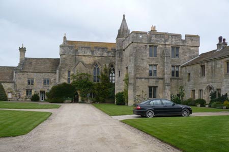
At the junction by the farm turn sharp left to follow an ancient footpath uphill through a copse. A track is soon reached (near Ingerthorpe Hall), turn right here to follow the track to the public road at SE294662 and then turn immediately left on a track known as Strait Lane. After 250m take the footpath on your right at SE293664. The Ripon Rowel route marked on the map was just before this but could not be seen in the field of crops. Markenfield Hall (pictured) can be seen as you approach it. This is a moated 12th century hall and is open to the public for several weeks each year. More details on the Hall's website. Continue right on the access road to the Hall for 100m before passing through a field gate on your left to pass close by the Hall.
Head north now via the path and track to SE297688 where you turn hairpin left. In woodland at SE292686 you drop downhill to the first of the bridges in the valley of the seven bridges (pictured). Here we enter the gorge of the River Skell and Studley Park (National Trust). A weir is found feeding the river from the lake at SE282692 (pictured). Our route now takes us on the estate roads uphill to SE280695 where we turn left onto the straight driveway to the Anglican St Mary's Church and the Obelisk. This is a deer park and there must be 100s freely grazing here.
Toilets and refreshments are available at the National Trust visitor centre at SE272686. We rejoin the private road which has a footpath alongside it down to SE269683 where we briefly join the public road before turning right along a path through Skell Bank Wood. At SE262680 a substantial footbridge takes us across the River Skell to join a country lane at SE261681. Turn right here following the lane to Sawley where refreshments are available at the Sawley Arms.
The third leg of this walk can be found here Walk 2405
Other walks nearby
| Walk 1358 | Ripley & Knox circular | easy | 5.5 miles |
| Walk 1078 | Hampsthwaite & Ripley Park | easy | 7.5 miles |
| Walk 3528 | Fountains Abbey & Markenfield Hall | moderate | 8.7 miles |
| Walk 2405 | Ripon Rowel Walk Leg 3 - Sawley to Ilton | moderate | 11.0 miles |
| Walk 2403 | Ripon Rowel Walk Leg 1 - Ripon to South Stainley | easy/mod | 10.0 miles |
| Walk 1800 | West of Harrogate without a car | easy/mod | 9.0 miles |
| Walk 3726 | Brimham Rocks Circular | easy | 4.7 miles |
| Walk 1095 | The Marton-cum-Grafton Eight | easy | 3.3 miles |
| Walk 3507 | Dacre Banks Circular | easy/mod | 6.5 miles |
| Walk 2261 | Pateley Bridge & Nidderdale Way | easy/mod | 7.1 miles |
Recommended Books & eBooks
Trail and Fell Running in the Yorkshire Dales
 Guidebook to 40 of the best trail and fell runs in the Yorkshire Dales National Park. Ranging from 5 to 24 miles, the graded runs start from bases such as Ribblehead, Dent, Sedbergh, Malham and Grassington and take in the region's diverse delights, from castles and waterfalls to iconic mountains such as Whernside, Ingleborough and Pen Y Ghent.
More information
Messaging & Social Media
Message Walking Britain and follow the latest news.

Mountain Weather
Stay safe on the mountains with detailed weather forecasts - for iOS devices or for Android devices.