Thirlmere Circular
Lake District Walk
Nat Park - Lake District - Lake District Central Fells
County/Area - Cumbria
Author - Mike Bexley
Length - 5.0 miles / 8.1 km Ascent - 350 feet / 106 metres
Time - 2 hours 50 minutes Grade - easy
Maps 

| Ordnance Survey Explorer OL5 | Sheet Map | 1:25k | BUY |
| Anquet OS Explorer OL5 | Digital Map | 1:25k | BUY |
| Ordnance Survey Landranger 90 | Sheet Map | 1:50k | BUY |
| Anquet OS Landranger 90 | Digital Map | 1:50k | BUY |
Walk Route Description
Click image to see photo description.
So you have half a day to spare! You have done the tops and you want a nice easy walk before you go shopping on the way home? Then this is the walk for you, offering wonderful views complemented with easy map reading and walking.
The walk starts at Legburthwaite car park (grid ref NY318196) just off the A591 Keswick to Ambleside main road. Under normal circumstances parking is usually easy and the car park has the benefit of toilets. After parking go through the northern gate and turn left along the lane to the main road. Cross the busy road to walk a short distance down the lane before going left then through the gate on the right.
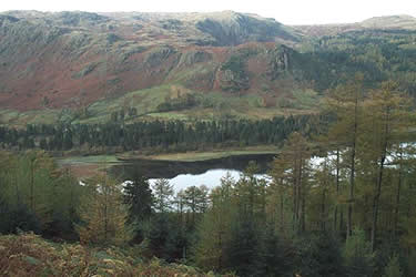
Follow the wide path through the woods. At the farm gate (grid ref 315185) turn right up the hill to a path junction where you turn left. This lovely path follows Thirlmere's shore line with many places to walk down to the waters edge and admire the views across to the other side with Raven Crag to the right, High Seat ahead and the Watendlath Fells to your left.
Continue to follow this path. Eventually it climbs alongside one of the feeder streams back to the main road and a lay-by. Cross over the road and take the footpath opposite that descends to a further car park with toilets. This is an alternative starting point (grid ref 317168). Go to the far left hand corner of the car park then over the footbridge. This is camera time! The view north up 'St Johns in the Vale' with Blencathra in the background is a superb Lakeland landscape and must for inclusion in any photo album.
The footpath climbs up from the bridge for a short distance. Turn left at the path junction and follow the path that proceeds north with the wall on your left. Keep on this path passing waterfalls, over a footbridge spanning a gill until the end (grid ref 322189). Here you reach the path climbing up from Stybeck Farm (on the left) to Sticks Pass high in the hills on your right. Proceed down this footpath over the wall passing the farm and on reaching the lane turn right past the YHA building back to the start.
Other walks nearby
| Walk 2019 | Raven Crag, the Benn & Shoulthwaite Gill near Thirlmere | easy/mod | 4.0 miles |
| Walk 2032 | Great How, a short ascent above Thirlmere | easy | 2.0 miles |
| Walk 1247 | Helvellyn & Raise from Swirls | mod/hard | 7.0 miles |
| Walk 2025 | Helvellyn & Wythburn from Swirls | mod/hard | 8.5 miles |
| Walk 3132 | High Tove & Blea Tarn | moderate | 7.6 miles |
| Walk 2587 | Castlerigg Stone Circle & St John's in the Vale | easy/mod | 8.5 miles |
| Walk 1356 | Walla Crag | easy/mod | 4.5 miles |
| Walk 1108 | Ashness Bridge & Grange Fell | moderate | 9.0 miles |
| Walk 2525 | Standing Crag & Dock Tarn from Watendlath | moderate | 7.0 miles |
| Walk 2526 | Standing Crag, Ullscarf & Borrowdale | mod/hard | 10.0 miles |
Recommended Books & eBooks
Lake District: Low Level and Lake Walks
 This guidebook describes 30 of the best low-level walks in the Lake District. From delightful wooded glades and sparkling tarns, to waterfalls and glacier-carved valleys towered over by craggy mountains. The walks described aim to seek out the best walking that the lower areas of the Lake District have to offer.
More information
Lake District: High Level and Fell Walks
 This guidebook describes 30 graded fell walks on the ridges and high peaks of the English Lake District, the UK's most popular national park. Reaching some of England's finest and highest mountain scenery, this guide leads readers to classic horseshoes and traditional ascents as well as lesser-known routes to quieter summits.
More information
Messaging & Social Media
Message Walking Britain and follow the latest news.

Mountain Weather
Stay safe on the mountains with detailed weather forecasts - for iOS devices or for Android devices.