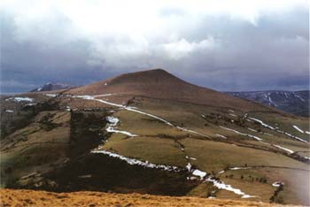
Castleton Great Ridge from Edale
Peak District Walk
Nat Park - Peak District - Great Ridge Castleton
County/Area - Derbyshire
Author - Jake Robertson
Length - 8.5 miles / 13.8 km Ascent - 1800 feet / 545 metres
Time - 6 hours 0 minutes Grade - moderate
Maps 

| Ordnance Survey Explorer OL1 | Sheet Map | 1:25k | BUY |
| Anquet OS Explorer OL1 | Digital Map | 1:25k | BUY |
| Ordnance Survey Landranger 110 | Sheet Map | 1:50k | BUY |
| Anquet OS Landranger 110 | Digital Map | 1:50k | BUY |
Walk Route Description
Click image to see photo description.
The Great Ridge sits on the Dark Peak - White Peak border and makes for a superb Peak District walk. This walk climbs up from Edale then embraces the full 4 mile long ridge before descending again. As would be expected from such a walk the views are stunning throughout.
Leave Edale car park (Grid ref. SK124853) and turn right onto the main road and follow it to reach a junction at a bridge in Barber Booth. Go right over the bridge and you should soon see a stile on the left. This path leads up through the fields to join the Chapel Gate track becoming quite faint at times. Go right with Chapel Gate and rise up the hillside to reach the moor. The track turns south, leading you to a National Trust signpost.
Turn left and follow the new path by the wall (which should be on your right), climbing steadily to the walk's summit at Lord's Seat which is marked by a tumulus. Absorb the glorious view then go over the stile and continue along the sloping ridge to Mam Nick. Walk right along the road to see a gate and path leading up Mam Tor on the left.
Take this path to ascend up to the OS trig point on Mam Tor. The view from Mam Tor ranks as one of the best in the Peak District but it is often crowded so it is best to press on to Hollins Cross. On blustery days Mam Tor is likely to have scarily strong winds blowing over it's summit so taking the path around it's northern side from Mam Nick is advised.
From Hollins Cross rise up over Barker Bank to the foot of Back Tor. Go over the stile on the left then ascend Back Tor, a charming little hill. Continue on the path, dipping then rising to the topograph on Lose Hill. Lose Hill is a wonderful summit and there is a small ditch on the eastern side which provides shelter and makes for a perfect snack stop.
Backtrack from Lose Hill to the foot of Back Tor then take a path on the right which descends to Backtor Farm past Backtor Nook. It then becomes a track, crossing the River Noe at Backtor Bridge to join the road. From here simply turn left walk for 1 mile along the road back to the car park.
Editor's Note - the route map shows alternative paths that can be used to avoid the road walking. At busy times this may be preferable.
Other walks nearby
| Walk 2522 | Rushup Edge & Edale from Mam Nick | moderate | 7.0 miles |
| Walk 1368 | Mam Tor, Upper Booth & Rushup Edge | moderate | 7.0 miles |
| Walk 1831 | Mam Tor & Hollins Cross from Mam Nick | easy | 3.0 miles |
| Walk 1688 | Old Dam & Sparrowpit from Mam Nick | moderate | 9.0 miles |
| Walk 1087 | Mam Tor & Cave Dale | moderate | 6.5 miles |
| Walk 1519 | Catleton & Speedwell Cavern Circular | easy | 4.3 miles |
| Walk 1521 | Cave Dale and Winnats Pass | easy | 4.5 miles |
| Walk 1665 | Hollins Cross & Lose Hill | easy/mod | 6.0 miles |
| Walk 3426 | Lose Hill & Hollins Cross | easy/mod | 5.0 miles |
| Walk 1489 | Blackden Brook, Kinder & Upper Ashop | moderate | 6.8 miles |
Recommended Books & eBooks
Walking in Derbyshire
 Walking guidebook to 60 circular day walks in Derbyshire and the Peak District. Includes the Derwent, Wye and Trent river valleys, near Derby, Matlock, Glossop, Bakewell and Ripley. Routes range from easy to moderate and are between 4 and 14km (2 to 10 miles). Walks focus on places of interest, from Stone Age forts to castles to grand estates.
More information
Dark Peak Walks
 Guidebook to 40 walks in the Dark Peak area of the Peak District National Park. 35 circular routes for most abilities, from 8km to 19km, around Edale, Marsden, Fairholmes, Baslow and Castleton, including Kinder Scout and Mam Tor, and 5 longer (25km to 45km) routes highlighting the best of the Gritstone Edges, High Moorland and Deep Valleys.
More information
Messaging & Social Media
Message Walking Britain and follow the latest news.

Mountain Weather
Stay safe on the mountains with detailed weather forecasts - for iOS devices or for Android devices.