Hebden Gill from Hebden
Yorkshire Dales Walk
Nat Park - Yorkshire Dales - Upper Wharfedale
County/Area - North Yorkshire
Author - Darren Hoyle
Length - 4.0 miles / 6.5 km Ascent - 750 feet / 227 metres
Time - 2 hours 50 minutes Grade - easy
Maps 

| Ordnance Survey Explorer OL2 | Sheet Map | 1:25k | BUY |
| Anquet OS Explorer OL2 | Digital Map | 1:25k | BUY |
| Ordnance Survey Landranger 98 | Sheet Map | 1:50k | BUY |
| Anquet OS Landranger 98 | Digital Map | 1:50k | BUY |
Walk Route Description
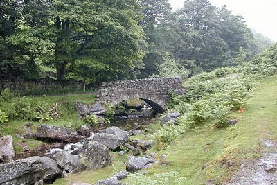
Click image to visit gallery of 3 images.
NOTE : Although this Yorkshire Dales walk is listed as Easy, some parts are a little strenuous and care must be taken especially in wet weather. DO also take care near old mine workings. For a longer version of this walk go to Walk 2610.
From the Post Office in Hebden cross over the B6265, and walk straight on up Town Hill, noting the wonderful bridge on your right over Hebden Beck. Continue along this lane past High Green and Knowles Lathe until after about 1km the lovely hamlet of Hole Bottom is reached. Go through the gate which is at the end of the small row of cottages and cross over the very picturesque stone bridge over Hebden beck. The walk now follows the old lead miners track for the next 3km.
The first of the mines passed here is the Longshaw Level and is now a source of water for Yorkshire Water, so care needed not to contaminate. On the opposite side is the remains of Dukes Level also a source of water, their are big mine tips here to. Continuing along the miners track and through several gates the Hebden Moor Mines Dressing Floors are reached, with many interesting mining features to look at. Once past the dressing floors look right into Bolton Gill where more mining relics are in evidence high up the gill. A short climb up the gill one can see the remains of the Bolton Gill Engine Shaft.
From here climb up to the rocky top of Bolton Haw, one can observe several stone pillars that dominate the skyline from within Hebden Gill. Return downstream towards the junction of Hebden Gill and Bolton Gill. However turn left before reaching the junction to return over Mossy Moor passing Mossy Moor Reservoir. Shortly afterwards there is a small prehistoric stone circle of eight stones, although they can be awkward to spot in the heather. Continuing along the track across Edge Top drop down back to Hebden via High Dene to walk back along the B6265 for about 350m back into Hebden Village.
Back in Hebden opposite the Post Office is a small Public Convenience which is very useful to change into those long awaited dry clothes, especially if you decided to walk on one of those nice wet days that only the Dales can provide. A warm welcome can be found in the nearby Clarendon Hotel.
Other walks nearby
| Walk 1280 | Trollers Gill | moderate | 9.0 miles |
| Walk 2000 | Wharfedale Circular | moderate | 13.5 miles |
| Walk 1145 | Grassington, Mastilles Lane & Conistone Dib | moderate | 11.3 miles |
| Walk 1645 | Grassington, Mastilles Lane & Conistone Dib | moderate | 12.0 miles |
| Walk 1846 | Garnshaw House & Linton Falls from Grassington | easy | 3.0 miles |
| Walk 1292 | Linton & Thorpe Fell & Cracoe | moderate | 9.0 miles |
| Walk 1407 | Thorpe & Burnsall from Linton | easy/mod | 6.2 miles |
| Walk 1573 | Grimwith Reservoir | easy | 4.5 miles |
| Walk 1576 | Embsay Reservoir | easy | 1.0 miles |
| Walk 1946 | Valley of Desolation & Simon's Seat | moderate | 8.4 miles |
Recommended Books & eBooks
Trail and Fell Running in the Yorkshire Dales
 Guidebook to 40 of the best trail and fell runs in the Yorkshire Dales National Park. Ranging from 5 to 24 miles, the graded runs start from bases such as Ribblehead, Dent, Sedbergh, Malham and Grassington and take in the region's diverse delights, from castles and waterfalls to iconic mountains such as Whernside, Ingleborough and Pen Y Ghent.
More information
Walking in the Yorkshire Dales: South and West
 Part of a two-book set, this guidebook describes 44 walks in the southern and western Yorkshire Dales, including the famous 23 mile Three Peaks circuit over Pen-y-Ghent, Whernside and Ingleborough. The other, mostly circular routes of 3½ to 13 miles cover the scenic region between Sedbergh, Kirkby Lonsdale, Settle, Skipton and Grassington.
More information
Messaging & Social Media
Message Walking Britain and follow the latest news.

Mountain Weather
Stay safe on the mountains with detailed weather forecasts - for iOS devices or for Android devices.