Oxenhope to Hebden Bridge without a car
South Pennines Walk
Region - South Pennines
County/Area - West Yorkshire - South Pennines
Author - Peter Schofield
Length - 11.0 miles / 17.9 km Ascent - 1700 feet / 515 metres
Time - 7 hours 10 minutes Grade - moderate
Maps 

| Ordnance Survey Explorer OL21 | Sheet Map | 1:25k | BUY |
| Anquet OS Explorer OL21 | Digital Map | 1:25k | BUY |
| Ordnance Survey Landranger 103 | Sheet Map | 1:50k | BUY |
| Anquet OS Landranger 103 | Digital Map | 1:50k | BUY |
| Ordnance Survey Landranger 104 | Sheet Map | 1:50k | BUY |
| Anquet OS Landranger 104 | Digital Map | 1:50k | BUY |
Walk Route Description
Click image to see photo description.
This linear walk over typical South Pennine peat moorland benefits from good transport connections enabling those without their own vehicle to easily access it. On the way, it visits a site associated with literary history and a beautiful wooded valley owned by the National Trust.
The route starts in the village of Oxenhope at the junction of the A6033 Hebden Bridge road and Shaw Lane (grid ref. SE031348). Go down Shaw Lane for just over a kilometre and turn left into Lee Lane by a row of cottages. A few yards before the gate to Leeshaw Reservoir, turn right up a clear path climbing past Westfield Farm, finally crossing a stile to reach a path. Go left along the path as it follows a wall to reach a finger post (grid ref. SE011356). Take the clear (and occasionally boggy) path bearing half right and signed to Top Withins. The path crosses the moor to join a broad track providing access to a house that can be seen ahead. Follow the track until 100m before the gate to the house is reached where a finger post points right towards a footbridge below.
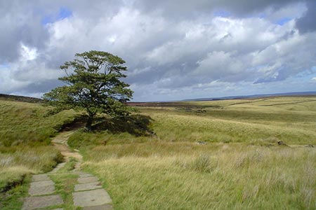
Cross the bridge and follow the path as it passes to the right of the house. Continue across the moor around the flank of Harbour Hill where the ruin of Top Withins guarded by its lonely tree can be seen on the hillside opposite. Keep straight ahead at a finger post as the path descends an attractive valley to cross both Crumber Dike and Rough Dike and reach a path junction at grid ref. SD987356. Turn left as the path gently climbs to meet the Pennine Way at a finger post, one of several hereabouts with both English and Japanese script reflecting the worldwide interest in the area's association with the Bronte sisters from nearby Haworth. Go left up the Pennine Way to arrive at the ruin of Top Withins after a few yards. This makes a fine spot for a refreshment break with stone benches outside offering expansive views should the weather permit.
Top Withins is popularly thought to be the Earnshaw home depicted in Emily Bronte's "Wuthering Heights" but there is no actual evidence of this. What is not in doubt is that the sisters knew the area well and the house and its remote location may have offered them inspiration in their literary work.
Continue gently uphill along the paved Pennine Way where it first levels and then descends towards the reservoirs in Walshaw Dean as the paving ends and the path becomes occasionally boggy. On reaching Walshaw Dean Middle Reservoir, turn left on to a water company vehicle track and continue for 200m to a junction where the Pennine Way turns right over a bridge. However, we leave the PW to go straight on up a broad track which passes two shooting cabins as it climbs Wadsworth Moor. Route finding is not a problem as the track continues across the moor to start descending towards the valley of Hebden Water. Ahead both Stoodley Pike and Heptonstall Church are prominent on the skyline.
The track descends to the hamlet of Walshaw. Turn left at the cottages and continue along the access road for 500m before bearing right on to a broad track descending into the wooded valley of Hardcastle Crags. Now owned by the National Trust, this is a delightful place to visit at any time. In Spring, it's a carpet of bluebells while the Autumn colours are truly spectacular. Continue along the track through the woods passing Gibson Mill which was built about 1800. It offers pleasant riverside refreshment stop at certain times of the year and also houses a small exhibition about the site and its history.
As the track reaches the car park at New Bridge (Grid ref. SD988291), turn right to descend to a bridge crossing Hebden Water and then immediately left to pass Midgehole WMC (known locally as The Blue Pig). After a few yards bear left at a finger post and follow the river bank to a bridge to ascend to a lane, continuing right along the lane for 300m. Bear right down a track and after 300m descend towards the river by a flight of steps beside a house. The path again crosses the river to go left and follow the bank to shortly arrive in Hebden Bridge and the end of the walk.
The start and finish points are linked every day at an hourly frequency by bus 500 during daytime hours. Hebden Bridge has frequent bus and train services to many centres in West Yorkshire and Lancashire and full travel information can be found on www.wymetro.com
Other walks nearby
| Walk 1307 | Circuit of Ovenden Moor from Oxenhope | moderate | 8.0 miles |
| Walk 1243 | Haworth Moor and Bronte Bridge from Oxenhope | easy | 3.5 miles |
| Walk 1585 | Haworth Moor circular | easy | 5.0 miles |
| Walk 1135 | Top Withins and the Bronte Bridge | moderate | 8.0 miles |
| Walk 1449 | Cullingworth Circular | easy/mod | 6.3 miles |
| Walk 1584 | Ogden Reservoir | easy | 4.0 miles |
| Walk 2121 | Crimsworth Dean, Lumb Bridge & Hardcastle Crags | moderate | 7.5 miles |
| Walk 1291 | Stoodley Pike | moderate | 11.0 miles |
| Walk 1952 | Five Rise Locks and the River Aire, Bingley | easy | 5.3 miles |
| Walk 1057 | Luddenden Dean and the Calderdale Way | easy/mod | 6.5 miles |
Recommended Books & eBooks
The Pennine Way
 Guidebook to the Pennine Way National Trail with OS map booklet. The 265 mile route from Edale to Kirk Yetholm takes three weeks to walk and is suitable for fit and experienced long distance walkers. The route crosses the Peak District, Yorkshire Dales and North Pennines National Parks. Includes separate OS 1:25,000 map booklet of the route.
More information
Pennine Way Map Booklet
 Map of the 270 miles (435km) Pennine Way National Trail, between Edale in the Peak District and Kirk Yetholm in the Scottish Borders. This booklet is included with the Cicerone guidebook to the trail, and shows the full route on Ordnance Survey 1:25,000 maps. This popular long-distance route typically takes three weeks to complete.
More information
Messaging & Social Media
Message Walking Britain and follow the latest news.

Mountain Weather
Stay safe on the mountains with detailed weather forecasts - for iOS devices or for Android devices.