Snowdon by Rhyd-Ddu and Snowdon Ranger Paths
Snowdonia/Eryri Walk
Nat Park - Snowdonia - Snowdon Crib Goch
County/Area - Gwynedd
Author - Lou Johnson
Length - 7.5 miles / 12.2 km Ascent - 3300 feet / 1000 metres
Time - 7 hours 0 minutes Grade - mod/hard
Maps 

| Ordnance Survey Explorer OL17 | Sheet Map | 1:25k | BUY |
| Anquet OS Explorer OL17 | Digital Map | 1:25k | BUY |
| Ordnance Survey Landranger 115 | Sheet Map | 1:50k | BUY |
| Anquet OS Landranger 115 | Digital Map | 1:50k | BUY |
Walk Route Description
Click image to see photo description.
Snowdon is a busy summit seeing crowds of visitors in fine weather. The most popular paths are the direct approach from Llanberis, the routes from Pen-y-pass and the Watkin Path reaching the summit from the south. In addition, there are many visitors arriving by train. Two less used routes are the Rhyd-Ddu and Snowdon Ranger paths which approach from the west. Both paths provide excellent walking in fine scenery with relative solitude. It is only when near the summit do you have to contend with the crowds and this is why the western approach is my personal favourite.
This Snowdonia (Eryri) walk needs some pre-planning. The preferred choice is to park at the Snowdon Ranger station on the Welsh Highland Railway and catch the train to Rhyd-Ddu. The train service is not frequent and it must be remembered that Snowdon Ranger is a request stop. Alternatively, park at Rhyd-Ddu station and after completion of the walk take the train from Snowdon Ranger station back to the start. The third option is described in the text and will return you to Rhyd-Ddu. If you choose to use the railway then make sure you are aware of the times of the trains.
From Rhyd-Ddu pay and display car park (grid ref. SH571526) walk to the Rhyd-Ddu village end of the station, cross the tracks using the purpose-built crossing and follow the clear track that heads southeast uphill towards Bwlch-Cwm Llan. It is a straightforward walk with the track allowing a fast pace along what was once an access road to the quarries and mines near Yr Aran. After 1.2 km, you reach a junction of paths (grid ref. SH582524). Go left here following the Rhyd-Ddu path. The route is mostly easy to follow and where the path is in doubt helpful cairns and waymarks assist route-finding.
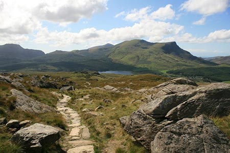
It is a steady ascent. With excellent views, both ahead to the Snowdon Massif and retrospectively to the Nantlle Ridge and Mynydd Mawr, you are rewarded for the effort expended. The path then follows the Lechog ridge with views across Cwm Clogwyn to the return route. Reaching Snowdon's South Ridge (grid ref. SH605537), bear left and continue to the summit of Snowdon probably in the company of many other walkers. The summit area is well worth exploring and it is possible to get away from the crowds and enjoy the view east towards Crib Goch, Y LLiwedd and Pen-y-Pass.
To continue the walk, leave the summit by following the wide path by the side of the railway descending to Llanberis. You will reach a rock signing the Snowdon Ranger Path to the left. Initially the path is unclear but in fine weather the way ahead is clear along the Clogwyn Du'r Arddu ridge. After a few hundred metres the path is clear on the ground with cairns helping with navigation as the path zigzags downhill. The view ahead is superb with the Nantlle Ridge dominating the panorama.
After passing Llyn Fynnon-y-gwas on your left, much of the descent is complete. A mile past the reservoir you reach a junction of paths (grid ref. SH575533). From here you can either descend to Snowdon Ranger Station or return to Rhyd-Ddu. If you are heading to Snowdon Ranger station stay on the main path and continue downhill following a series of zigzags down to the railway. If you want to return to Rhyd-Ddu, then cross the ladder stile on your left at this junction and follow the path down into the valley. This option adds about 2 miles to the total distance.
Other walks nearby
| Walk 3613 | Moel Cynghorion from Llyn Cwellyn | moderate | 5.0 miles |
| Walk 3060 | Moel Lefn & Moel yr Ogof | moderate | 7.0 miles |
| Walk 2150 | Llyn Dinas and Cwm Bychan from Beddgelert | easy/mod | 6.0 miles |
| Walk 2560 | Moel Hebog, Moel yr Ogof & Moel Lefn from Beddgelert | mod/hard | 6.5 miles |
| Walk 1799 | Moel Hebog | moderate | 5.5 miles |
| Walk 1988 | Beddgelert, Moel Hebog, Meol yr Ogof & Moel Lefn | mod/hard | 6.8 miles |
| Walk 3074 | Mynydd Sygun | moderate | 4.5 miles |
| Walk 3231 | Moel Hebog, Meol yr Ogof and Moel Lefn from Beddgelert | mod/hard | 6.8 miles |
| Walk 1426 | Aberglaslyn and Cwm Bychan | easy/mod | 5.8 miles |
| Walk 1427 | Craflwyn circular from near Beddgelert | easy/mod | 2.5 miles |
Recommended Books & eBooks
Mountain Walking in Snowdonia
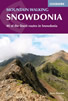 Guidebook to 40 of Snowdonia's best day walks, with routes up Snowdon and Tryfan, including the Snowdon Horseshoe, Cadair Idris, Y Garn and The Rhinogs. The routes range from Grade 1 scrambles like Crib Goch or Bristly Ridge, to riverside and forest walks. Includes details of a 2-day traverse of all 15 of Snowdonia's 3000ft peaks.
More information
Snowdonia: 30 Low-level and easy walks - South
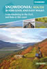 Guidebook describing 30 walks in Snowdonia, Wales. Routes are mostly low level and on clear paths and showcase the region's beautiful scenery and rich history and culture. Part of a 2-volume set, this southern volume includes Trawsfynydd, Bala, Dolgellau, Machynlleth, the Harlech Coast and the valleys of the Mawddach and Dyfi.
More information
Messaging & Social Media
Message Walking Britain and follow the latest news.

Mountain Weather
Stay safe on the mountains with detailed weather forecasts - for iOS devices or for Android devices.