Moel Faban, Gyrn & Moel Wnion from Rachub
Snowdonia/Eryri Walk
Nat Park - Snowdonia - Western Carneddau
County/Area - Gwynedd
Author - Lou Johnson
Length - 5.0 miles / 8.1 km Ascent - 1250 feet / 379 metres
Time - 3 hours 50 minutes Grade - easy/mod
Maps 

| Ordnance Survey Explorer OL17 | Sheet Map | 1:25k | BUY |
| Anquet OS Explorer OL17 | Digital Map | 1:25k | BUY |
Walk Route Description
Click image to see photo description.
The wild open spaces of the Carneddau have always had an appeal especially the high summits. Heading for those high peaks little time was ever wasted on the lower tops and this walk hopes to address those oversights of earlier more youthful days in the hills. The start of this Snowdonia (Eryri) walk is the small village of Rachub located about 600 feet above sea level on the north-western slopes of the Carneddau. Parking in this village is at a premium although I found a space on Stryd Fawr at its junction with Bryn Pistyll at grid ref. SH625680.
After parking head east up Stryd Fawr to a T-junction with Mountain Road. Turn right and continue to the end of this street. Go through the metal gate and turn immediately left following a path ascending the lower slopes of Moel Faban. You soon reach a point at the lower end of an old incline (grid ref. SH628679). Bear right here following a path trending south and then south-east towards to reach a junction of paths just north of Tyddyn-Sabel (grid ref. SH631675).
Turn north-east here and follow the path to the summit of Moel Faban from where you get good views and the chance to see the next section of the walk to the summit of Gyrn. From Moel Faban my route took me north-east to descend to the Bwlch between Moel Faban and Llefn. Reaching the bottom, I initially headed south-east before turning left onto a clear rising path across the eastern slope of Llefn. There are a number of paths as you climb and I took the most convenient route to reach the summit of Gyrn (grid ref. SH647687).
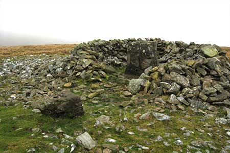
With two summits completed the final objection, Moel Wnion, can be seen ahead. I headed north-east from Gyrn passing the rocks on my right and made a beeline for Moel Wnion. The summit is crowned with a rough shelter and the remains of an OS trig point. On a fine day the view towards Anglesey is superb.
To return to the start, I headed west from Moel Wnion picking the easiest route down its slopes and aiming for the junction of paths at grid ref. SH639697. From here I turned south soon reaching the western end of the Bwlch between Moel Faban and Llefn. Shadowing the wall on my right I descended easily to the metal gate at the end of Mountain Road and returned back to my car.
Other walks nearby
| Walk 1315 | Drosgl and Gyrn Wigau from Rachub | moderate | 7.5 miles |
| Walk 2115 | Yr Elen, Carnedd Llewellyn & Carnedd Dafydd | hard | 9.5 miles |
| Walk 3051 | Yr Elen from Gerlan | hard | 6.5 miles |
| Walk 3052 | Yr Elen & Carnedd Dafydd from Gerlan | hard | 9.0 miles |
| Walk 2558 | Carnedd Dafydd & Pen yr Ole Wen from Bethesda | mod/hard | 8.0 miles |
| Walk 1074 | The Glyders Traverse | very hard | 12.0 miles |
| Walk 3020 | Aber Falls, Foel-fras & Drum | mod/hard | 9.0 miles |
| Walk 3021 | Northern Carneddau | mod/hard | 12.0 miles |
| Walk 1453 | Elidir Fawr, Mynydd Perfedd & Marchlyn Mawr reservoir | moderate | 6.0 miles |
| Walk 2346 | Yr Orsedd ridge from near Bont Newydd | moderate | 4.8 miles |
Recommended Books & eBooks
The Cambrian Way
 Guidebook to the Cambrian Way, a challenging three-week mountain trek through Wales from Cardiff to Conwy. The 470km un-waymarked route is presented from south to north. Often sticking to long, beautiful ridgelines, it crosses wild and rugged terrain and visits many of Wales's highest mountains, including Snowdon.
More information
Great Mountain Days in Snowdonia
 Inspirational guidebook to 40 great mountain day walks and scrambles in Snowdonia. Inspirational routes for all abilities across the National Park with routes up Snowdon and Moel Eilio, the Glyderau, the Carneddau, Eifionydd, Siabod and the Moelwynion, Rhinogydd (the Harlech Dome), Migneint and the Arans and Cadair Idris and the Tarrens.
More information
Messaging & Social Media
Message Walking Britain and follow the latest news.

Mountain Weather
Stay safe on the mountains with detailed weather forecasts - for iOS devices or for Android devices.