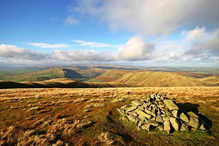
Fell Head & The Calf from Howgill
Howgills Walk
Nat Park - Yorkshire Dales - Howgill Fells
Region - Howgills
County/Area - Cumbria
Author - Lou Johnson
Length - 7.5 miles / 12.2 km Ascent - 1975 feet / 598 metres
Time - 5 hours 40 minutes Grade - moderate
Maps 

| Ordnance Survey Explorer OL19 | Sheet Map | 1:25k | BUY |
| Anquet OS Explorer OL19 | Digital Map | 1:25k | BUY |
| Ordnance Survey Landranger 97 | Sheet Map | 1:50k | BUY |
| Anquet OS Landranger 97 | Digital Map | 1:50k | BUY |
| Ordnance Survey Landranger 98 | Sheet Map | 1:50k | BUY |
| Anquet OS Landranger 98 | Digital Map | 1:50k | BUY |
Walk Route Description
Click image to see photo description.
This walk in the Howgills is easy to follow in good visibility. However if there is any likelihood of low cloud then those with a poor sense of direction should head back down the fell. Even when the sun is shining the complex ridge structure is confusing and it is imperative that you ensure you are equipped with the 1:25000 map, which has been studied before setting out.
The start is problematic as there is very restricted parking. You may be lucky to find a space near to Four Lane Ends (grid ref. SD632958) either on Howgill Lane or the lane that drops down to Lowgill. If this is not possible then park on the grass verge above Fairmile Gate (grid ref. 629980) although this option adds over a mile and a half to the length of the route.
From Four Lane Ends head north along Howgill Lane. Just before Gate House on the left, turn right along the drive that leads through Beck Houses. Passing the farm, continue on the signed right of way crossing a stream to reach the intake wall at Beck Houses Gate. From here follow the rising path that leads in a wide arc to reach Whin's End. Note - if you have parked at Fairmile Gate then a more direct path will bring you to this same point.
Continue on the main path that heads northeast to cross Blind Gill before it turns to head north to reach the col between Linghaw and Fell Head. At the Col turn right up a feint path that leads northeasterly onto Blake Ridge before veering south towards the summit of Fell Head, which is marked by a cairn. Now that you have gained some height you soon appreciate the complexity of the topography in this area with deep valleys separated by lofty ridges. Note there is a direct path from Whin's End to the summit of Fell Head but the route described is far more pleasant.
Leave Fell Head on the main path heading east and then north east descending to arrive at Breaks Head. From here there is a steeper descent to the Col of Windscarth Wyke before a climb south east to Bush Howe. Staying on the ridge path continue over White Fell Head to reach the trig column on the Calf where you may actually meet another walker enjoying the superb all round view!
Retrace your steps towards White Fell Head from where a descent southwest on a feint path leads you down to a crossing of Chapel Beck. If for some reason you fail to locate the path used on this descent then you should encounter no problems by just walking down over grass. Cross Chapel Beck and pick up the track that leads past Castley Farm and Cookson's Tenement to reach the start.
Other walks nearby
| Walk 2458 | Winder, The Calf & Fell Head | moderate | 9.8 miles |
| Walk 3385 | Carlingill Beck, Black Force & Whin's End | mod/hard | 6.5 miles |
| Walk 3008 | Winder & Arant Haw from Sedbergh | moderate | 7.0 miles |
| Walk 2438 | Cautley Spout & the Calf from Sedbergh | moderate | 10.0 miles |
| Walk 1196 | The Calf | mod/hard | 10.5 miles |
| Walk 3006 | Cautley Spout & The Calf | moderate | 5.5 miles |
| Walk 1393 | Yarlside | moderate | 4.0 miles |
| Walk 1387 | Cautley Spout | easy | 2.0 miles |
| Walk 2253 | Uldale Falls & Wandale | moderate | 8.5 miles |
| Walk 1839 | Blease Fell & Hare Shaw from Tebay | easy/mod | 5.7 miles |
Recommended Books & eBooks
Walking the Lake District Fells - Patterdale
 Part of the Walking the Lake District Fells series, this guidebook covers a wide range of routes to 35 Lakeland summits that can be climbed from Ambleside, Grasmere and Patterdale and the Thirlmere and Ullswater valleys, with highlights including Helvellyn and Fairfield. Suggestions for longer ridge routes are also included.
More information
Walking the Lake District Fells - Keswick
 Part of the Walking the Lake District Fells series, this guidebook covers a wide range of routes to 30 Lakeland summits that can be climbed from Keswick, Whinlatter, Bassenthwaite, Caldbeck, Mungrisdale and Threlkeld, with highlights including Skiddaw and Blencathra. Includes suggestions for longer ridge routes.
More information
Messaging & Social Media
Message Walking Britain and follow the latest news.

Mountain Weather
Stay safe on the mountains with detailed weather forecasts - for iOS devices or for Android devices.