Stob Ban (Mamores) from Glen Nevis
Highland Walk
County/Area - Highland - Fort William Lochaber
Author - Peter Smyly
Length - 6.0 miles / 9.8 km Ascent - 3000 feet / 909 metres
Time - 6 hours 0 minutes Grade - mod/hard
Maps 

| Ordnance Survey Explorer 392 | Sheet Map | 1:25k | BUY |
| Anquet OS Explorer 392 | Digital Map | 1:25k | BUY |
Walk Route Description
Click image to visit gallery of 6 images.
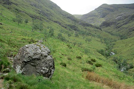
When seen from the Glen Nevis valley, the white quartzite atop the shapely peak of Stob Ban can be mistaken for snow. Stob Ban (meaning white peak) is one of the Munros in the Mamores range of the north-west highlands of Scotland. It may not hold the same attraction as Ben Nevis across the glen, and it sees far fewer walkers, but this is a very satisfying mountain to climb and it has all the attributes you would expect of one of the more rugged and picturesque mountains in Scotland.
It is described here as a "there and back" route rather than a circular one. It is strongly recommended that you choose a clear day for the walk as there are magnificent views especially of the other peaks in the Mamores range and Ben Nevis, Carn Mor Dearg, Aonach Mor and Aonach Beag (the "Lochaber giants", all of them over 4,000 feet). The route also reveals Stob Ban itself at its best, its rugged attributes seen to dramatic effect with its cliffs and buttresses seen on the approach route to the bealach. Then the same view is starkly apparent to the right of the narrow and steep ridge leading to the top from the bealach, a prospect that some may find intimidating but the route is not as tricky as it might appear.
The route itself requires little by way of description. Start in Glen Nevis at the car park near to Achriabach (grid ref. NN145683) and follow the road for a short distance up the valley to locate the start of the stalker's path. The path leads steadily up the glen between Stob Ban on the right and Sgurr a' Mhaim on the left and the views get increasingly better the higher up you go. At one point the path overlooks a gorge on the right with only a steep slope separating the two before a series of bends to the left and then begins the ascent to the bealach and thence on to the top.
Other walks nearby
| Walk 1338 | Ben Nevis Tourist Path | mod/hard | 8.7 miles |
| Walk 3270 | Ben Nevis | mod/hard | 9.7 miles |
| Walk 2105 | Ben Nevis via Carn Mor Dearg arete | hard | 10.5 miles |
| Walk 3106 | Binnein Mor from Kinlochleven | hard | 10.2 miles |
| Walk 1039 | Am Bodach and Stob Coire a' Chairn | mod/hard | 9.5 miles |
| Walk 1094 | Blackwater Reservoir | moderate | 11.5 miles |
| Walk 1496 | WHW - Day 6 - Kinlocheven to Fort William | moderate | 15.0 miles |
| Walk 3066 | Carn Mor Dearg (via Allt a' Mhuilinn trail) | mod/hard | 8.7 miles |
| Walk 2918 | Aonach Mor and Aonach Beag - two of the "Lochaber giants" | mod/hard | 9.0 miles |
| Walk 1162 | Pap of Glencoe | moderate | 4.2 miles |
Recommended Books & eBooks
Walking in Torridon
 This guidebook contains 52 day walks in Torridon, a remote and much-loved area of the Scottish Highlands. Based around Shieldaig and Slioch, the routes are split into 3 sections: easy walks, long and high level walks and mountain ascents over 2000ft including 9 Munros, and 5 outline suggestions for major ridge walks.
More information
Walking the Munros Vol 2 - Northern Highlands and the Cairngorms
 Guidebook to walking the northern Munros, covering the northern Highlands, the Cairngorms and the Isle of Skye. 70 routes are described, including those up Ben Macdui, Braeriach and Cairn Gorm. Routes range from 7 to 46km, requiring a fair level of fitness. The second of two guidebooks to walking Scotland's Munros: peaks higher than 3000ft.
More information
Messaging & Social Media
Message Walking Britain and follow the latest news.

Mountain Weather
Stay safe on the mountains with detailed weather forecasts - for iOS devices or for Android devices.