Wimpole Park and Whaddon
Cambridgeshire Walk
County/Area - Cambridgeshire
Author - Barry Mackie
Length - 8.3 miles / 13.4 km Ascent - 150 feet / 45 metres
Time - 4 hours 20 minutes Grade - easy/mod
Maps 

| Ordnance Survey Explorer 209 | Sheet Map | 1:25k | BUY |
| Anquet OS Explorer 209 | Digital Map | 1:25k | BUY |
| Ordnance Survey Landranger 154 | Sheet Map | 1:50k | BUY |
| Anquet OS Landranger 154 | Digital Map | 1:50k | BUY |
Walk Route Description
Click image to visit gallery of 12 images.
Situated some 8 miles to the southwest of Cambridge, Wimpole Park just on its own has plenty to offer for a great day out. This walk, both starting and finishing in the park, includes a brief look at some of its highlights before setting out to see some of rural Cambridgeshire. The outskirts of the village of Whaddon are visited before continuing on to finish the walk back at the park. First time visitors to this part of Britain will be struck by the uniqueness of this, the East Anglia countryside, with its dark rich soils, very sporadic woodlands and flat landscape criss-crossed by many drainage ditches.
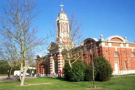
Leave the car park (grid ref TL338 510) and head west past both the clock tower and then the church, to reach the front of the very grand looking Wimpole Hall. This imposing 17th/18th century building, the focal point in the park, is apparently the largest house in Cambridgeshire.
Go south on the drive from the front of the house to reach the path, the Harcamlow Way, that crosses some 80 metres away. Turn right onto this distinct track and walk through the pleasant parkland, typically predominately grazing land with mature trees, heading initially in a westerly and then a south westerly direction to reach the side entrance gates of the park at the village of Arrington. Leave the park via the exit to the left side of the gates and turn left along the pavement to walk through the village and past a pub until you reach the last thatched cottage on your left.
Turn left away from the road and follow the waymarked path, signed New Wimpole, in a south east direction across arable fields to reach the wooden footbridge (grid ref TL 335 496) that spans the first of several ditches seen on the walk Cross here and enter Wimpole Avenue, a ninety yard wide and two and a half mile long section of grassed land stretching from the Hall towards the Hertfordshire border in the distance. On reaching the next footbridge on the far side of the avenue, do not cross, but instead turn right and walk down this side of the avenue to reach and cross the A603 road.
Continue south, veering to the centre of the avenue in order to cross the River Cam or Rhee to reach the octangular shaped lake, which is passed to the left side. It is a bit of a shame as the pool, impressive on the map, was completely choked with long grasses and rushes when we saw it (early Spring 2008). Go past the pool to reach the farm track that traverses the avenue at grid ref TL338479 and turn left here to leave the avenue. Follow this track south east, at first alongside trees and then a ditch. In the distance if the visibility is good, you will see the church tower at Whaddon, which is the general line to aim for.
The path brings you to the bend in the road on Church Lane at Whaddon (grid ref TL348 465). From here, go left along the lane to view St Mary's Church on the right side. At the next bend turn left away from the road, as indicated by the waymarked path (signed to Orwell) alongside the right side of the light industrial unit, turning right a few metres further along at grid ref TL351 468. Here the Explorer map shows the route to the right side of a ditch, but a slightly easier and more popular path can be taken by keeping to the left of this ditch. Whichever way you choose, both routes will lead you past Hoback Farm on the right, to reach the copse and King's Bridge which is the route over the River Cam/Rhee. To get to the bridge, take the obvious route through the copse. I know that beauty is in the eye of the beholder and also that this bridge functions perfectly in its prime role of assisting one to gain the far side of the river, but this is quite simply the ugliest structure imaginable. So ugly in fact, I could not persuade myself to take a picture of it!
Moving on the path now clearly waymarked, heads, first in a north-northeast and then a north-northwest direction out into the open countryside; initially through the golf course. A minor detail, but worth noting is that the path shown on the map, veering to the right at grid ref TL361 486 does not seem to exist. Instead, continue to follow the ditch line to the end and turn right alongside the crossing ditch to pick up again with the Explorer map at grid ref TL361 488. Follow the line of the deep ditch on your left again in a north-northwest direction and then veer northeast to ascend the only hill of note met on the walk When you get to the path crossing and the hedge in front of you, (grid ref TL335 495) turn left and head southwest for approximately 250metres to then right to reach the road. Cross the road and continue alongside the lane to reach the entrance of the Wimpole Estate on your left, where all that remains is to walk along the driveway to reach the car parks and the end of the walk
Note - Wimpole Park is owned and managed by the National Trust. Various parts are only open at specific times and dates. However the parkland mentioned in this walk is open all year. Car parking is free to National Trust members; otherwise it is £ 2 for the day (2008 prices).
How to get there - Wimpole Park is easily accessed from the A1M motorway via junction 9 for Letchworth/Royston. Head for Royston on the A505 and at the outskirts of the town, take the A1198 and follow the signs to Wimpole Park.
Other walks nearby
| Walk 2243 | Mare Way & Wimpole Estate from Orwell | easy | 5.2 miles |
| Walk 1599 | Therfield Heath circular from near Royston | easy/mod | 6.5 miles |
| Walk 2305 | Gamlingay, Tetworth & Everton from Potton | easy/mod | 9.5 miles |
| Walk 1963 | Elsworth & Conington | moderate | 10.1 miles |
| Walk 1812 | Therfield to Royston & Reed Circular | easy/mod | 10.0 miles |
| Walk 1118 | Roe Green and Sandon from Therfield circular | easy/mod | 7.3 miles |
| Walk 3113 | Sandy and Everton Circular | easy/mod | 7.5 miles |
| Walk 2107 | Reed to Nuthampstead Circular | easy/mod | 7.3 miles |
| Walk 3721 | Oakington and Longstanton round via Rampton Drift | easy | 6.0 miles |
| Walk 2123 | Everton & Potton | moderate | 12.0 miles |
Recommended Books & eBooks
No suggestions for this area.Messaging & Social Media
Message Walking Britain and follow the latest news.

Mountain Weather
Stay safe on the mountains with detailed weather forecasts - for iOS devices or for Android devices.