Creag Choinnich circular from Braemar
Cairngorms Walk
Nat Park - Cairngorms - Cairngorm South
County/Area - Aberdeenshire
Author - Andy Smith
Length - 4.0 miles / 6.5 km Ascent - 1000 feet / 303 metres
Time - 3 hours 0 minutes Grade - easy/mod
Maps 

| Ordnance Survey Explorer OL58 | Sheet Map | 1:25k | BUY |
| Anquet OS Explorer OL58 | Digital Map | 1:25k | BUY |
Walk Route Description
Click image to visit gallery of 9 images.
This charming small hill overlooking the village of Braemar has a lot to offer with outstanding views of the River Dee valley and the southern Cairngorm range. It is best enjoyed in the height of summer due to the huge variation of wildlife and should not be missed if staying in the area. The route is mainly flat apart from the initial ascent which should last no more than 30 minutes, therefore making it a good choice for a family with children 10 years and above. It is worth bearing in mind the wind can be an issue however, even if it is quite still on the ground as this area is very exposed.
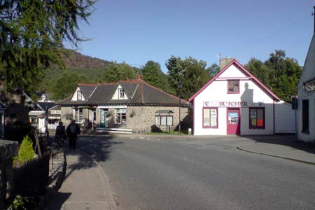
There is plenty of parking options within Braemar village, the most obvious being the free car park behind the butchers and toilet block next to the river. Leave the car park crossing the main road to follow the sign for Creag Choinnich up the small side road passing the school on your right. Within minutes the road turns hard right, take the gate on the left into the woods, once again signed Creag Choinnich and turn left uphill (grid ref. NO155914).
The path ahead is now very clear as you climb steady though the woods into the clearing high above. Once clear of the trees it is only another 10 minutes or so to the summit. Already the views to your left of the village are quite impressive as you finish off the ascent of this great hill. Once on top you take in 360 degree views of this stunning area. Linn of Dee valley tears away to your west whilst the mighty Balmoral Forest dominates views to the east. It is also well worth noting the 15th century house nestling in the forest which makes an impressive photo to say the least.
Picnic over and family fed, leave the summit to the northeast facing the castle and bearing slightly right. The track at first can be hard to locate but once found it is well walked as you bear right though the bracken. The path now drops steeply into the forest still with great views all around. This track is not listed on the town plans so therefore expect to escape the crowds at least for a while! After 15 minutes the path meets a wall (grid ref. NO163916). Ignore the track off to your right and head straight on until you reach a T junction, turn left here signed the Lion's Face (grid ref. NO164915).
The path continues on a ledge with spectacular views across the River Dee as you make your way underneath the Lion's Face rock. This huge piece of limestone simulates a giant lion when viewed from the other side of the River Dee. Continue on downhill slightly as the path turns almost back on itself and runs parallel with the road for a while. After passing some more interesting features you find yourself opposite Braemar Castle, which is well worth a visit. The castle is only open to the public at weekends but you are free to view the grounds and take pictures, care should be taken when crossing the road as traffic moves fast here.
Leave the castle and take the path opposite signed The Cromwell. Walk past the viewpoint and continue back into the forest where after a short while the path meets up with the Creag Choinnich ascent track you started on. Turn right and walk back down into the village as you reflect on a short but wonderful afternoon out in this beautiful part of Scotland.
Other walks nearby
| Walk 2706 | Morrone (Morven) | moderate | 7.4 miles |
| Walk 1864 | Glen Quoich & Glen Lui (near Braemar) | moderate | 10.0 miles |
| Walk 1119 | Ben Macdui & Carn a' Mhaim | hard | 19.0 miles |
| Walk 2356 | The Cairnwell ridge from Glenshee Ski Centre | mod/hard | 9.3 miles |
| Walk 1881 | Ben Macdui & Cairn Lochan from the Ski Centre | hard | 10.4 miles |
| Walk 2672 | Cairngorm Mountain via Coire an t-Sneachda | mod/hard | 6.0 miles |
| Walk 1390 | Cairn Lochan via the Fiacaill Buttress from Ski Centre | very hard | 5.7 miles |
| Walk 1276 | Loch Avon Circular via Cairn Gorm Mountain | hard | 9.0 miles |
| Walk 2314 | Cairngorm & Ben Macdui from the ski centre | hard | 11.0 miles |
| Walk 2421 | Braeriach via the Chalamain Gap | hard | 15.0 miles |
Recommended Books & eBooks
Great Mountain Days in Scotland
 Inspirational guidebook to 50 challenging routes for mountaineers, scramblers, hillwalkers and fell runners, many long enough to backpack over 2 days, especially in winter (12 to 25 miles). A mix of classic routes and unsung gems across Scotland from Galloway to the Outer Hebrides in widely differing wild landscapes. With customised OS mapping.
More information
Messaging & Social Media
Message Walking Britain and follow the latest news.

Mountain Weather
Stay safe on the mountains with detailed weather forecasts - for iOS devices or for Android devices.