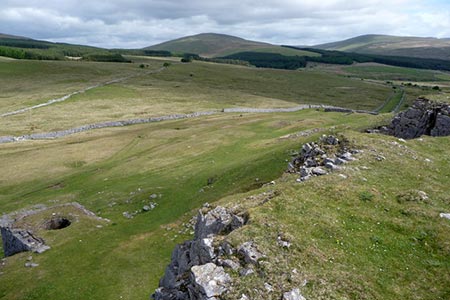
Carnau Gwynion from Ystradfellte
Brecon Beacons/Bannau Brycheiniog Walk
Nat Park - Brecon Beacons - Brecon Beacons West
County/Area - Powys
Author - Martyn Hanks
Length - 4.0 miles / 6.5 km Ascent - 600 feet / 182 metres
Time - 2 hours 40 minutes Grade - easy
Maps 

| Ordnance Survey Explorer OL12 | Sheet Map | 1:25k | BUY |
| Anquet OS Explorer OL12 | Digital Map | 1:25k | BUY |
| Ordnance Survey Landranger 160 | Sheet Map | 1:50k | BUY |
| Anquet OS Landranger 160 | Digital Map | 1:50k | BUY |
Walk Route Description
Click image to see photo description.
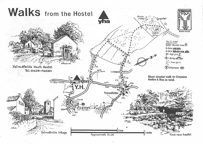
The valley containing the Afon Mellte in the Brecon Beacons National Park is famous for its waterfalls. This short walk offers the explore the surrounding limestone scenery visiting the summit of Carnau Gwynion which lies northwest of the village of Ystradfellte. The start of this walk is the Four Waterfalls car park (grid ref. SN928124) and the route uses footpaths, country lanes and upland tracks to gain the high ground.
After parking exit the car park and turn right along the lane. Where the lane bends to the right, take the footpath on the left crossing a stile in a short section of stone wall. Follow the path across several fields to reach the main valley road (grid ref. SN924126). Turn right and continue to the next road junction. Turn left here up the access driveway to Penllwyn-Einon. Where the driveway bends to the right continue straight ahead on a clear track initially through trees. 600 metres beyond the trees the track splits (grid ref. SN919135). Take the right fork (the clearer of the two tracks) and continue in a northerly direction to a gate in a wall (grid ref. SN919143).
The track passes between two limestone outcrops with Carnau Gwynion on the right. Climb to the summit and enjoy the views across the Mellte Valley and north to the mountains of Fforest Fawr. Retrace your steps, go through the wall and after 100 metres, where the track splits, bear left and follow the track down to a wall corner (grid ref. SN923138). Follow the track with the wall on your left and join what was a walled track. This leads down to join the access driveway to Tyle Farm (grid ref. SN926134). Continue ahead on the driveway down to the valley road and New Inn at Ystradfellte (grid ref. SN930134).
Turn left and almost immediately right down the lane signed to 'Waterfalls' with the church on your left. Follow this lane passing the Post Office on your left. Continue along the lane over the Afon Mellte. The lane passes the entrance to Porth yr Ogof Farm on your right, bends left and enters a wooded area. Take the waymarked path on the right crossing a stile adjacent to a metal gate (grid ref. SN931130). Follow this path initially through trees and across fields back to the Four Waterfalls car park used at the start.
This walk is one of many routes prepared by Martyn Hanks for Youth Hostellers. The routes were drawn in a 'Wainwright' style and provided annotated maps offering additional information for walkers. Prepared before the days of GPS they were an invaluable resource and Walking Britain is happy to ensure that these walks remain in the public domain.
Other walks nearby
| Walk 2643 | Fan Frynych & Fan Llia, Fforest Fawr | moderate | 8.0 miles |
| Walk 3616 | Fan Fawr from Storey Arms | moderate | 6.0 miles |
| Walk 2349 | Pen Y Fan & Corn Du from near Storey Arms | moderate | 4.6 miles |
| Walk 2645 | Fan Gyhirych & Fan Bwlch Chwyth, Fforest Fawr | moderate | 8.0 miles |
| Walk 2646 | Fan Nedd & Fan Bwlch Chwyth, Fforest Fawr | moderate | 7.0 miles |
| Walk 2647 | Fan Gyhirych, Fan Nedd & Fan Bwlch Chwyth | moderate | 10.0 miles |
| Walk 2641 | Fan Fawr & Fan Frynych, Fforest Fawr | moderate | 6.5 miles |
| Walk 1123 | Brecon Beacons Horseshoe | moderate | 8.5 miles |
| Walk 2934 | The High Peaks of the Brecon Beacons | mod/hard | 10.7 miles |
| Walk 3563 | Fan Brycheiniog and Picws Du | moderate | 7.1 miles |
Recommended Books & eBooks
Walking on the Brecon Beacons
 45 circular day walks are described in this guidebook to the Brecon Beacons National Park. From west to east, Mynydd Du, Fforest Fawr, the Brecon Beacons and the Black Mountains these mountain and valley routes offer many options, highlighting the natural features. The walks described explore dramatic waterfalls, wooded gorges and upland valleys.
More information
Walking in Carmarthenshire
 Guidebook to 30 walking routes (2 to 10 miles) in Carmarthenshire, south Wales, including sections of Carmarthenshire Coast Path. Walks for all abilities, including coastal, river, forest and hill walks in Cambrian Mountains, Tywi Valley, Y Mynydd Du (Black Mountains) and Brecon Beacons. Easy access from Bristol, Cardiff and Swansea.
More information
Messaging & Social Media
Message Walking Britain and follow the latest news.

Mountain Weather
Stay safe on the mountains with detailed weather forecasts - for iOS devices or for Android devices.