Hidcote & Ilmington Down
Cotswolds Walk
Region - Cotswolds
County/Area - Warwickshire & Gloucestershire
Author - Lou Johnson
Length - 8.0 miles / 13 km Ascent - 1000 feet / 303 metres
Time - 5 hours 0 minutes Grade - easy/mod
Maps 

| Ordnance Survey Explorer 201 | Sheet Map | 1:25k | BUY |
| Anquet OS Explorer 201 | Digital Map | 1:25k | BUY |
| Ordnance Survey Landranger 151 | Sheet Map | 1:50k | BUY |
| Anquet OS Landranger 151 | Digital Map | 1:50k | BUY |
Walk Route Description
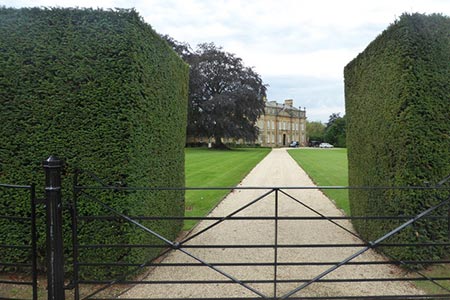
Click image to see photo description.
This Cotswolds walk explores the countryside surrounding the most northerly hills in the region. The start is the Warwickshire village of Ilmington from where the route continues to the picturesque village of Ebrington in Gloucestershire. The walk continues across rolling countryside to Hidcote, where you can visit one of Britain's finest gardens at Hidcote Manor. The final part of the route climbs onto Ilmington Down, the highest point in Warwickshire, before a gentle descent back to the start.
There is limited parking in Ilmington by village green in front of the Roman Catholic Church (grid ref. SP210433). Take the lane immediately in front of this Church and follow it south-west between houses and cottages. Gaining height, the lane reaches a large gate (grid ref. Grid ref. SP206429). Do not go through this gate but turn right through a smaller metal gate and then almost immediately left through another gate onto a footpath climbing through fields with a boundary fence on your left.
Reaching Pig Lane (grid ref. SP204425) the initial ascent is over. Go straight across the lane and descend into the parkland of Foxcote House. You soon reach a tarmac drive. Go right along this drive passing the entrance to Foxcote House and continue to Foxcote Farm. Here, keep straight ahead on a track. On OS maps the bridleway is shown taking a short cut across a field (grid ref. SP194413). It is easier to stay on the track as there is no clear path cross the field. The track crosses the county border into Gloucestershire and becomes Nash's Lane leading you without any navigational problems into the picturesque village of Ebrington.
Reaching a road (grid ref. SP187401) go right and walk through Ebrington to reach a road junction by the pub, which is on your left. Turn right here and continue past some very attractive thatched cottages in the direction of Mickleton. Walk past the school and take the signed footpath on your right (grid ref. SP183403). There is also a sign to the 'Recreation Ground'. Take this track, which soon narrows to a path, and continue across meadows following the clear waymarks to reach a lane (grid ref. SP180411). Go straight ahead and follow the clear path across more meadows to reach a lane (grid ref. SP175416) at a T-junction. Follow the lane into the small hamlet of Hidcote Boyce. Turn right in the village. Just after the last building on your left take the signed path half left across fields towards Hidcote Bartrim.
Joining a road, walk past the cottages to reach the entrance to Hidcote Manor on your left. Administered by the National Trust, this is the home of one of Britain's great gardens (admission fee payable). There is also a plant centre where a small café provides refreshments in season. Continue along the lane to reach a road junction (Grid ref. SP177430). Turn right here and follow the track uphill onto Ilmington Down. Reaching a junction in the track, turn right and follow the track left to reach a radio station. You are now close to the highest point in Warwickshire.
Just past the radio station you reach a lane (grid ref. SP187425). Go straight across and follow the track downhill to reach a road (grid ref. SU193426). Cross the road and take the track opposite. This leads you in an easterly direction to reach Pig Lane which you crossed earlier in the walk (grid ref. SP204425). Turn left here and retrace your route back into Ilmington village.
Other walks nearby
| Walk 3212 | Ebrington & Foxcote circular | easy | 3.7 miles |
| Walk 2541 | Hidcote & Foxcote from Mickleton | easy/mod | 7.5 miles |
| Walk 1749 | Upper Quinton & Hidcote Bartrim from Mickleton | easy/mod | 6.8 miles |
| Walk 3665 | Honington & Idlicote Circular | easy/mod | 6.0 miles |
| Walk 1308 | Broadway & Chipping Campden | moderate | 11.0 miles |
| Walk 1359 | Stratford-upon-Avon from Milcote | easy/mod | 7.0 miles |
| Walk 2489 | Upper Brailes Circular | easy/mod | 5.6 miles |
| Walk 2673 | Stratford-upon-Avon circular | easy | 3.8 miles |
| Walk 3734 | Compton Verney Circular | easy/mod | 7.2 miles |
| Walk 3072 | Broadway, Stanton & Laverton | easy/mod | 7.5 miles |
Recommended Books & eBooks
The Cotswold Way
 Guidebook to walking the Cotswold Way National Trail. Between Chipping Campden and Bath, the 102 mile route explores the Cotswolds AONB. Described in both directions over 13 stages, the Cotswold Way can be walked year round and is suitable for beginner trekkers. Includes separate OS 1:25,000 map booklet of the route.
More information
The Cotswold Way Map Booklet
 Map of the 102 mile (163km) Cotswold Way National Trail, between Chipping Camden and Bath. This booklet is included with the Cicerone guidebook to the trail, and shows the full route on OS 1:25,000 maps. The trail typically takes two weeks to walk, and is suitable for walkers at all levels of experience.
More information
Messaging & Social Media
Message Walking Britain and follow the latest news.

Mountain Weather
Stay safe on the mountains with detailed weather forecasts - for iOS devices or for Android devices.