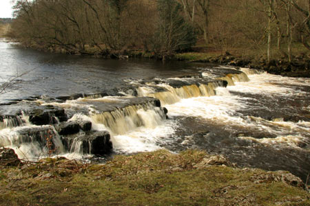
Redmire Force & the Templar's Chapel from West Witton
Yorkshire Dales Walk
Nat Park - Yorkshire Dales - Wensleydale
County/Area - North Yorkshire
Author - Lou Johnson
Length - 6.7 miles / 10.9 km Ascent - 600 feet / 182 metres
Time - 4 hours 0 minutes Grade - easy/mod
Maps 

| Ordnance Survey Explorer OL30 | Sheet Map | 1:25k | BUY |
| Anquet OS Explorer OL30 | Digital Map | 1:25k | BUY |
| Ordnance Survey Landranger 98 | Sheet Map | 1:50k | BUY |
| Anquet OS Landranger 98 | Digital Map | 1:50k | BUY |
Walk Route Description
Click image to see photo description.
This Yorkshire Dales walk includes one of the longest sections of footpath beside the River Ure in Wensleydale with a visit to Redmire Force an added bonus. Route finding is generally easy although some care is needed with navigation. The latter half of the walk includes the opportunity to see the Chapel of the Knights Templar which, for some, is somewhat disappointing.
The start is the small parking area at the eastern end of West Witton at grid ref. SE063884 where you can park on a wide verge. Luckily this is adjacent to the first section of the route. After parking take the adjacent walled lane heading north from the A684. At the first fork bear right and continuing along the lane as it winds downhill towards the River Ure. The walled lane ends and you enter a field. Keep close to the left-hand wall and continue to the river.
The next section of the route follows the River Ure upstream. The onward path leaves the river and with a wall on your right cross a stile and walk to the corner of the next field where another stile will be found. Cross this stile and following a clear path through trees you soon reach Redmire Force. After Redmire Force the path climbs away from the river and leaves the woodland. Continuing to follow the path across a number of fields you reach Stony Scoop Lane (grid ref. SE031895). Turn left along this partially enclosed track and follow it to reach the A684.
With care turn left along the main road. Just before Temple Farm take the stile on the right and join the farm track that leads south across a field to reach a wood. The track then climbs through trees with a stile on the left allowing access to the remains of the Chapel of the Knights Templar. You may be impressed or not but the remains which include some graves date from the early thirteenth century.
To continue, walk to the top of the field following an indistinct track. Continuing into the next field you reach a concrete track. Continue uphill on along this track until it bends right. Here leave the concrete track and walk uphill to a gate in a wall. Turning east, cross the next field to a further gate and another field. Keep the wall on your immediate right and you will soon locate a stile. This provides access to the walled Langthwaite Lane. Walk east along this lane with Nossill Scars and the flanks of Penhill above to your right. After three quarters of a mile the walled lane exits onto a tarmac lane (grid ref. SE053882). Walk straight ahead and continue to the A684. Turn right along the main road and walk through the village back to the start.
Other walks nearby
| Walk 1055 | Penhill & West Burton | moderate | 10.0 miles |
| Walk 3384 | Aysgarth Falls and Caperby | easy | 4.0 miles |
| Walk 1680 | Haw Lane & Aysgarth Moor | easy/mod | 6.3 miles |
| Walk 2190 | Calver Hill & Reeth Low Moor | easy/mod | 6.0 miles |
| Walk 1694 | Nappa Hall & Whitfield Gill Force | easy/mod | 6.0 miles |
| Walk 2822 | Aysgarth & Castle Bolton | mod/hard | 14.5 miles |
| Walk 1571 | Scar House & Angram Reservoirs | easy | 4.0 miles |
| Walk 3524 | Semer Water and Cam High Road from Bainbridge | easy/mod | 5.7 miles |
| Walk 1252 | Great Pinseat | easy/mod | 5.5 miles |
| Walk 2265 | Semer Water, Stalling Busk & Marsett | easy | 4.0 miles |
Recommended Books & eBooks
Walking in the Yorkshire Dales: South and West
 Part of a two-book set, this guidebook describes 44 walks in the southern and western Yorkshire Dales, including the famous 23 mile Three Peaks circuit over Pen-y-Ghent, Whernside and Ingleborough. The other, mostly circular routes of 3½ to 13 miles cover the scenic region between Sedbergh, Kirkby Lonsdale, Settle, Skipton and Grassington.
More information
Trail and Fell Running in the Yorkshire Dales
 Guidebook to 40 of the best trail and fell runs in the Yorkshire Dales National Park. Ranging from 5 to 24 miles, the graded runs start from bases such as Ribblehead, Dent, Sedbergh, Malham and Grassington and take in the region's diverse delights, from castles and waterfalls to iconic mountains such as Whernside, Ingleborough and Pen Y Ghent.
More information
Messaging & Social Media
Message Walking Britain and follow the latest news.

Mountain Weather
Stay safe on the mountains with detailed weather forecasts - for iOS devices or for Android devices.