Hadrian's Wall, Walltown Crags & Aesica
Northumberland Walk
Nat Park - Northumberland
County/Area - Northumberland County
Author - Lou Johnson
Length - 5.0 miles / 8.1 km Ascent - 770 feet / 233 metres
Time - 3 hours 20 minutes Grade - easy/mod
Maps 

| Ordnance Survey Explorer OL43 | Sheet Map | 1:25k | BUY |
| Anquet OS Explorer OL43 | Digital Map | 1:25k | BUY |
| Ordnance Survey Landranger 86 | Sheet Map | 1:50k | BUY |
| Anquet OS Landranger 86 | Digital Map | 1:50k | BUY |
| Ordnance Survey Landranger 87 | Sheet Map | 1:50k | BUY |
| Anquet OS Landranger 87 | Digital Map | 1:50k | BUY |
Walk Route Description
Click image to visit gallery of 12 images.
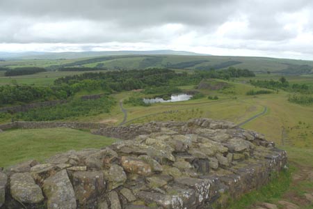
Hadrian's Wall runs for 73 miles across northern England and construction started in AD 122. The wall remained in use until the 5th century by which time the Romans had departed. Today there is still significant evidence of the wall with some sections restored or rebuilt to show their impregnable and intimidating construction. This walk includes one of the best preserved sections of Hadrian's Wall to the north of Haltwhistle.
The start is a small car park (Grid ref NY675662), which is reached by taking the B6318 east from Greenhead and taking the first left turn to the Wall and Roman Army Museum. Just opposite the Museum turn right down a narrow tarmac lane. The parking area is on the left just before a sign restricting further access to the lane. After parking, walk up the grass slope. Reaching one of the best preserved sections of the wall, it worth spending a few minutes and walking west (turning left) along the wall to overlook the large quarry before retracing your steps and continuing along the wall in an eastward direction.
The path follows the wall and it is difficult to lose your way. Passing Walltown Quarry you will soon realise that the wall follows an undulating route and that there are plenty of ups and downs to this walk. Just after Walltown Quarry you reach Milecastle 45. These intermediate fortifications were spread along the wall every Roman Mile and offered access through the wall and additional fortifications. You will have noticed that evidence of the wall gradually reduces and in places the remains are very sparse. Reaching Great Chesters Farm you can investigate the site of Aesica Roman Fort where remains of buildings and a shrine are easily seen.
The walk leaves the wall here. Turn right down the track towards the road. At the first junction (Grid ref. NY704664) turn right and follow a clear track. This track follows the course of the Vallum, an auxiliary defensive ditch. Stay on this track to just before Walltown Farm. Here turn right and on reaching the wall, turn left and return along the wall back to the start.
Other walks nearby
| Walk 1198 | Hadrian's Wall & Steel Rigg | moderate | 8.0 miles |
| Walk 2337 | Greenlee Lough and Steel Rigg | easy/mod | 7.5 miles |
| Walk 3404 | Hadrian's Wall - Cawfields to Steel Rigg | easy/mod | 3.5 miles |
| Walk 1677 | Peel Crags & Winshield Crags from Vindolanda | easy/mod | 7.8 miles |
| Walk 2671 | Hotbank Crags & Housesteads from Vindolanda | easy | 5.3 miles |
| Walk 3331 | Cragend & Crow Crags from Housesteads | easy/mod | 8.4 miles |
| Walk 1987 | Allendale Town Circular | easy/mod | 6.6 miles |
| Walk 2803 | Hadrian's Wall and Haughton Common | hard | 20.0 miles |
| Walk 2195 | Alston & Garrigill | easy/mod | 8.7 miles |
| Walk 1786 | Hadrian's Wall & Simonburn circular | easy/mod | 6.8 miles |
Recommended Books & eBooks
Hadrian's Wall Path
 Hadrians Wall Path guidebook to walk the 84 mile National Trail. Described in both directions, the main description is west to east between Bowness-on-Solway and Wallsend, Newcastle, with extensions to Maryport and South Shields. With extensive historical information related to this World Heritage site and separate 1:25,000 OS map booklet included.
More information
The Pennine Way - the Path, the People, the Journey
 A portrait of the The Pennine Way, Britain's oldest and best known long-distance footpath, stretching 268 miles from the Peak District to the Scottish Borders. This personal, thoughtful and often humorous story of the path's remarkable history, includes the experiences of walkers and local characters on this exhilarating and complex path.
More information
Messaging & Social Media
Message Walking Britain and follow the latest news.

Mountain Weather
Stay safe on the mountains with detailed weather forecasts - for iOS devices or for Android devices.