Kinder Scout Summit from Edale
Peak District Walk
Nat Park - Peak District - Kinder Scout Edale
County/Area - Derbyshire
Author - Jake Robertson
Length - 8.5 miles / 13.8 km Ascent - 1800 feet / 545 metres
Time - 6 hours 0 minutes Grade - moderate
Maps 

| Ordnance Survey Explorer OL1 | Sheet Map | 1:25k | BUY |
| Anquet OS Explorer OL1 | Digital Map | 1:25k | BUY |
| Ordnance Survey Landranger 110 | Sheet Map | 1:50k | BUY |
| Anquet OS Landranger 110 | Digital Map | 1:50k | BUY |
Walk Route Description
Click image to see photo description.
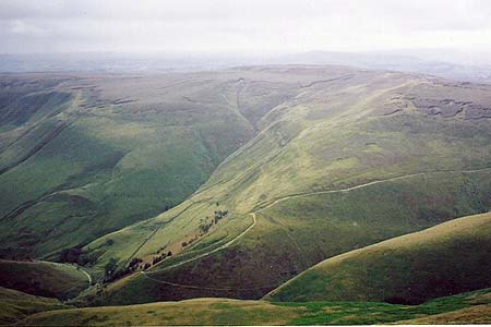
Though one of England's most popular and important mountains, the 2088ft summit of Kinder Scout is an unfrequented place due its boggy nature. However, this direct route is well worth doing, an exciting and little done scramble onto the plateau and a dramatic descent, it should bring out another aspect of the mountain. Because of its fragile nature of the terrain, this route is best done either on your own or in small groups.
To start this Peak District walk, leave the main car park at Edale (Grid ref. SK124853) and walk up the road into the village. Join the Pennine Way on the left just past the post office. Well signposted, this gives an easy and dramatic walk up the valley as far as Youngate Bridge at the foot of Jacob's Ladder (Grid ref. SK088861).
Leave the Pennine Way and head up the stream on its east bank. Suddenly the place is very quiet, only the sound of waterfalls breaks the silence. Keep with the stream until you reach a large confluence with a stream dropping down from the north. This is the stream that flows from the summit.
Progress up the clough is quite hard, waterfalls force you to make steep climbs around them and the tightness of the clough gives little room for manoeuvre. Higher up the stream a rocky bed makes going easier. A delightful scramble up the rocky bed and small waterfalls leads to the main edges path near Noe Stool.
A different world is entered as you go north up a grough onto the plateau. When it becomes to tight, climb out onto the moor. Ahead should be a cairn and a stake, reached by a short walk over the bogs. The summit (known as The Peak) is wild, wet place with excellent views over the Peak District, you really feel on top of the world (Grid ref. SK085875).
The safest way out of the bogs is to make a direct line for Pym Chair then go to the nearby Pagoda. A clear (if badly eroded) path heads through the fascinating Woolpacks to the top of Crowden Tower (2030ft) then drops steeply to the head of Crowden Clough Grid ref. SK094872), a super view. Climb up on a clear path over the moor to a rocky outcrop on the crest. Take a reasonably dry path over a subsidiary top to the 1970ft summit of Grindslow Knoll, one of my favourite hills.
Though the normal way to Edale goes down the long east slope, it is a nice alternative to descend the south ridge and follow a path over the moor past two small pools (Grid ref. SK110862). As you gain the top of Broadlee Bank swing west to the lip of the moor. The path makes a swift but very steep descent down to the Pennine Way, though the grand view of Kinder and Lord's Seat takes away some of the pain. From the Pennine Way, retrace you steps back into Edale.
A few interesting facts about the summit. There are 3 points which reach 2088ft, the one with the cairn and stake is accepted as the top. Its name is also a mystery, called The Peak, Edale Head and Point 636 by some. I myself prefer to call it The Peak. Also, it is the highest ground in England south of Fountains Fell, over 50 miles away.
Other walks nearby
| Walk 2522 | Rushup Edge & Edale from Mam Nick | moderate | 7.0 miles |
| Walk 1368 | Mam Tor, Upper Booth & Rushup Edge | moderate | 7.0 miles |
| Walk 1831 | Mam Tor & Hollins Cross from Mam Nick | easy | 3.0 miles |
| Walk 1688 | Old Dam & Sparrowpit from Mam Nick | moderate | 9.0 miles |
| Walk 1087 | Mam Tor & Cave Dale | moderate | 6.5 miles |
| Walk 1519 | Catleton & Speedwell Cavern Circular | easy | 4.3 miles |
| Walk 1521 | Cave Dale and Winnats Pass | easy | 4.5 miles |
| Walk 1665 | Hollins Cross & Lose Hill | easy/mod | 6.0 miles |
| Walk 3426 | Lose Hill & Hollins Cross | easy/mod | 5.0 miles |
| Walk 1489 | Blackden Brook, Kinder & Upper Ashop | moderate | 6.8 miles |
Recommended Books & eBooks
Great Mountain Days in the Pennines
 An inspirational guidebook to 50 classic walks on the rolling Pennine landscape. The graded routes, between 6 and 13 miles in length, cover classic Pennine fells and moorland such as Whernside, Ilkley Moor and Pendle Hill; exploring the North and South Pennines, Yorkshire Dales, Howgills and Dark Peak. Many routes are also suited to fell running.
More information
Dark Peak Walks
 Guidebook to 40 walks in the Dark Peak area of the Peak District National Park. 35 circular routes for most abilities, from 8km to 19km, around Edale, Marsden, Fairholmes, Baslow and Castleton, including Kinder Scout and Mam Tor, and 5 longer (25km to 45km) routes highlighting the best of the Gritstone Edges, High Moorland and Deep Valleys.
More information
Messaging & Social Media
Message Walking Britain and follow the latest news.

Mountain Weather
Stay safe on the mountains with detailed weather forecasts - for iOS devices or for Android devices.