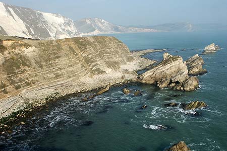
Bindon Hill and the Fossil Forest from Lulworth
Jurassic Coast Walk
Region - Jurassic Coast
County/Area - Dorset
Author - Lou Johnson
Length - 4.0 miles / 6.5 km Ascent - 900 feet / 273 metres
Time - 2 hours 50 minutes Grade - easy/mod
Maps 

| Ordnance Survey Explorer OL15 | Sheet Map | 1:25k | BUY |
| Anquet OS Explorer OL15 | Digital Map | 1:25k | BUY |
| Ordnance Survey Landranger 194 | Sheet Map | 1:50k | BUY |
| Anquet OS Landranger 194 | Digital Map | 1:50k | BUY |
Walk Route Description
Click image to visit gallery of 3 images.
Known as the Jurassic Coast, the south coast of England from East Devon to Purbeck in Dorset is one of the most significant earth science sites in the world, displaying a remarkable combination of internationally renowned features. This walk visits two of the important features, namely Lulworth Cove and the Fossil Forest, in a circular route that also provides fine views east to Kimmeridge Bay.
The start is the main car park next to the visitor centre at Lulworth Cove (Grid ref. SY821800). This can be a very busy place during peak times and if you prefer a quiet walk then do avoid peak holiday periods. Exit the car park and turn left along the B3070 towards West Lulworth. Turn right into Bindon Road.
The climb starts here and after 100 metres take the footpath signed on the right hand side of the road (Grid ref SY823804). Do not take the path alongside the fence towards the sea but instead follow the path going half left steeply uphill. Stay on this path and continue uphill to reach the ridge of Bindon Hill, which you follow eastwards to join a track just past a radio facility. Stay on this track and enjoy the extensive views especially towards Worbarrow Bay and along the coast to Kimmeridge.
Continue along the track towards its end and then descend on the path to join the South West Coast Path (SWCP). Reaching this National Trail, turn left and follow it down to the cliffs above Mupe Bay. Erosion on the side of Bindon Hill has caused the SWCP to be diverted and there are signs warning of potential dangers. Stay on the coastal path past Mupe Rocks to reach the Fossil Forest, the most complete fossil record of a Jurassic forest in the world.
Just past the fossil forest the waymarked path leaves the coast to head inland to reach Little Bindon (Grid ref. SY830798). Turn left after this derelict farm and follow the waymarked path down to the shores of Lulworth Cove, one of the most famous features within the World Heritage Site, to reach the shingle beach. Turn right along the beach back to the slipway where you can regain the road and walk the short distance uphill back to the start.
Other walks nearby
| Walk 2568 | Egmont Point & Kimmeridge Bay from Tyneham | moderate | 14.0 miles |
| Walk 1533 | Gad Cliff, Povington Hill & Tyneham | easy/mod | 4.5 miles |
| Walk 2575 | Durdle Door & Lulworth Cove | moderate | 10.0 miles |
| Walk 1889 | White Nothe from Ringstead Bay | easy/mod | 5.8 miles |
| Walk 1331 | Kimmeridge & Tyneham | easy/mod | 6.8 miles |
| Walk 1534 | Swyre Head & Tyneham Cap from Kimmeridge | moderate | 11.8 miles |
| Walk 1995 | Houns-tout & Swyre Head from Kimmeridge | moderate | 8.7 miles |
| Walk 1597 | The White Horse & Sutton Poyntz from Osmington | easy/mod | 4.0 miles |
| Walk 2440 | White Nothe & Moigns Down from Osmington | moderate | 10.5 miles |
| Walk 2145 | Houns-tout Cliff from Kingston | easy | 3.5 miles |
Recommended Books & eBooks
The South West Coast Path
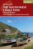 Guidebook to walking the entire South West Coast Path National Trail. The route runs for 630 miles from Minehead to Poole along the north Devon, Cornish, south Devon and Dorset coastline. Divided into 45 stages, this long-distance coastal trek could be completed within 4 weeks, or walked in sections. Guide includes maps and essential information.
More information
South West Coast Path Map Booklet - Minehead to St Ives
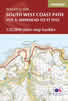 Map of the northern section of the 630 mile (1014km) South West Coast Path National Trail. Covers the trail from Minehead to St Ives along the north Devon and Cornish coastline. This convenient and compact booklet of Ordnance Survey 1:25,000 maps shows the route, providing all of the mapping you need to walk the trail in either direction.
More information
Messaging & Social Media
Message Walking Britain and follow the latest news.

Mountain Weather
Stay safe on the mountains with detailed weather forecasts - for iOS devices or for Android devices.