Beinn Resipol from Resipole Farm
Highland Walk
County/Area - Highland - Fort William Lochaber
Author - Tony Maries
Length - 7.0 miles / 11.4 km Ascent - 2700 feet / 818 metres
Time - 6 hours 10 minutes Grade - moderate
Maps 

| Ordnance Survey Explorer 390 | Sheet Map | 1:25k | BUY |
| Anquet OS Explorer 390 | Digital Map | 1:25k | BUY |
| Ordnance Survey Landranger 40 | Sheet Map | 1:50k | BUY |
| Anquet OS Landranger 40 | Digital Map | 1:50k | BUY |
Walk Route Description
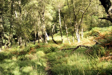
Click image to visit gallery of 8 images.
This walk starts from the caravan site by Resipole Farm (grid ref. NM 724638). There is parking for a couple of cars opposite the site entrance. Ben Resipol is one of the few well-walked hills in this part of the West Highlands. The 'standard' route found in print and on-line is boggy and eroded higher up the hill where it passes through the Glac Gharbh. This walk follows an alternative up the west face of the mountain, which is steeper and may take a little longer. However the views are incomparably finer and your feet should stay drier as well.
If transport can be arranged you can combine this walk with Walk 1161, which climbs Resipol from Strontian to the east. You can then use one walk for the ascent and the other to go back down. Beware that if you intend to try thumbing a lift back to your starting point there is very little traffic on the main road. The bus service is also somewhat vestigial (one service a day). Your best option is probably to leave a bicycle at the finishing point, or book the local taxi.
From the caravan site, walk past the site reception, and head north out the northern boundary of the site into the woods, gradually turning more to the east as you reach the end of the trees at about the 150m contour. The path generally follows the south-east bank of the Allt Mhic Chiarain. Presently both path and burn enter a gorge and you start to climb more steeply. A tune often gets a bit more rhythm into your legs and stops the tedium creeping into a climb. Today it was the Cal Mac, composed by Fergie MacDonald, who lives at Mingarrypark on the shores of Loch Shiel. Early in his long career, Fergie and his band were banned from broadcasting by the BBC for ten years. They were informed that the fiddler was 'mashing up his notes'. Over forty years later, I do my best to mash up my notes properly.
As you reach the end of the gorge the views start to unfold and mountain and loch start to predominate. To the south twenty mile-long Loch Sunart separates Sunart from Morvern to the south. Sunart and neighbouring Ardgour and Ardnamurchan are almost an island, separated from neighbouring land masses by lochs Sunart, Linnhe, Shiel and Eil. Only at Lochailort is there a narrow isthmus and a land connection to the mainland. The district was formerly much more isolated than it is today. The road from Lochailort to Salen was only completed in the 1960s. The ferry at Corran and the very roundabout road from Kinlocheil are the only other points of vehicular access to the district.
By the time you reach the 500m contour Beinn Resipol is in full view. Leave the path and walk due east and climb the west face of the mountain. Lochan Bac an Lochain generally provides a good guide to your whereabouts. There is no path, and the mountain side is steep. However the rapid gain in height also means a rapid unfolding of views. The going underfoot is over grass and rock, and any major crags can easily be avoided. Any signs of the passage of feet are as likely from sheep or deer as humans. You will not see the top until you are almost onto it.
Resipol actually has three summits, quite close together. The highest point of the mountain is the westernmost, with a fine cairn on the top.
The relative isolation of the mountain from other large mountains means that on a nice day, there is a commanding view from the top over a huge swathe of the West Highlands and even beyond. To the east the major mountain masses of Ben Nevis, the Mamores, Aonach Eagach and Bidean nam Bian are easily picked out. To the north the wild and unpopulated interior of Moidart, on the far side of sinuous Loch Shiel. Nearly twenty miles away at the far end of the loch is Glenfinnan, where Prince Charles Edward Stuart raised his standard in the uprising of 1745. Further afield there is the whole of the Ardnamurchan peninsular, Mull, Skye, and Torridon. Just beyond Bidean nam Bian the tiny blue pyramidal shadow is faraway Schiehallion, on the other side of Rannoch Moor.
If you are returning to Resipol, the best way down is to head north off the top towards the watershed at the top of the Glac Gharbh. A boggy path leads down the burn for about 1 km to where you meet the outward route.
Other walks nearby
| Walk 3506 | The Silver Walk & Castle Tioram, Loch Moidart | moderate | 9.5 miles |
| Walk 1161 | Beinn Resipol | hard | 9.0 miles |
| Walk 1813 | Sgurr Dhomhnuill | mod/hard | 8.0 miles |
| Walk 2597 | Cnoc an Sroine from Selen | easy/mod | 6.0 miles |
| Walk 1735 | Monadh Beag and Meall a' Phubuill | hard | 16.5 miles |
| Walk 3699 | The Black Lochs from Connel | easy/mod | 6.0 miles |
| Walk 1163 | Fraoch Bheinn | moderate | 5.0 miles |
| Walk 1162 | Pap of Glencoe | moderate | 4.2 miles |
| Walk 1234 | Pap of Glencoe (Route B) | moderate | 4.2 miles |
| Walk 3000 | Sgorr Nam Fiannaidh & Stob Coire Leith | hard | 6.2 miles |
Recommended Books & eBooks
Walking the Munros Vol 2 - Northern Highlands and the Cairngorms
 Guidebook to walking the northern Munros, covering the northern Highlands, the Cairngorms and the Isle of Skye. 70 routes are described, including those up Ben Macdui, Braeriach and Cairn Gorm. Routes range from 7 to 46km, requiring a fair level of fitness. The second of two guidebooks to walking Scotland's Munros: peaks higher than 3000ft.
More information
Walking in Torridon
 This guidebook contains 52 day walks in Torridon, a remote and much-loved area of the Scottish Highlands. Based around Shieldaig and Slioch, the routes are split into 3 sections: easy walks, long and high level walks and mountain ascents over 2000ft including 9 Munros, and 5 outline suggestions for major ridge walks.
More information
Messaging & Social Media
Message Walking Britain and follow the latest news.

Mountain Weather
Stay safe on the mountains with detailed weather forecasts - for iOS devices or for Android devices.