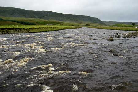
Cronkley Fell from Hanging Shaw
North Pennines Walk
Region - North Pennines
County/Area - Durham
Author - Lou Johnson
Length - 7.0 miles / 11.4 km Ascent - 800 feet / 242 metres
Time - 4 hours 20 minutes Grade - easy/mod
Maps 

| Ordnance Survey Explorer OL19 | Sheet Map | 1:25k | BUY |
| Anquet OS Explorer OL19 | Digital Map | 1:25k | BUY |
Walk Route Description
Click image to see photo description.
This walk in Upper Teesdale, County Durham, takes you through some wonderful scenery typical of the area. The start is the small car park near Hanging Shaw (grid ref. NY867298) on the north side of the B6277 just under 6 miles north-west of Middleton-in-Teesdale.
After parking exit the car park and turn right. After a few yards, bear left down the driveway and continuing footpath down to the bridge over the River Tees (grid ref. NY862293). Once over the River Tees, bear right and follow the farm access road. Just after it bends to the left, leave the driveway to follow the clear path on your right. This leads without any navigational problems to High House (grid ref. NY856294) and the path along the south bank of the River Tees. Stay on this path for two and quarter miles passing beneath Cronkley Scar and Raven Scar. The path is flanked by steep ground to your right for most of the way. However, after passing through a wall at grid ref. NY833287), you reach a more open area. Pass through another wall in 300 metres into an enclosed field. About half way along this field bear left through a gate and follow a clear rising path/track onto Cronkley Fell.
The way ahead goes to the left of a walled enclosure and then soon after to the right of a further three walled enclosures. You are now descending and shortly after the last enclosure a wall appears to your left. The route parallels this wall, crosses Birk Rigg and a little further on you will see a gate in the wall on your left (grid ref. NY860280). Turn left through the wall and follow a well-used path to meet the Pennine Way (also the Pennine Journey) at grid ref. NY861282). Keep straight ahead on the Pennine Way continuing through Cronkley Farm. Stay on the Pennine Way to reach the bridge over the River Tees used towards the beginning of the walk. All that remains is to retrace your route back to the B6277 where a right turn takes you back to the car park.
Other walks nearby
| Walk 3099 | High Force, Low Force and the River Tees | easy/mod | 7.5 miles |
| Walk 3274 | Cronkley Scar & Cauldron Snout | moderate | 8.0 miles |
| Walk 1683 | High Cup Nick & Cow Green Reservoir | moderate | 12.8 miles |
| Walk 3336 | Cauldron Snout | easy | 3.6 miles |
| Walk 3593 | Meldon Hill from Cow Green Reservoir | moderate | 9.2 miles |
| Walk 1005 | Harter Fell & Grassholme | moderate | 8.0 miles |
| Walk 1482 | Crossthwaite Common from Middleton-in-Teesdale | moderate | 9.8 miles |
| Walk 1483 | Eggleston & Romaldkirk from Middleton-in-Teesdale | easy/mod | 9.8 miles |
| Walk 1484 | Kirkcarrion from Middleton-in-Teesdale | easy | 3.5 miles |
| Walk 1485 | Hamsterley & Middleton-in-Teesdale | mod/hard | 16.5 miles |
Recommended Books & eBooks
Walking in County Durham
 Guidebook offering detailed descriptions of 40 day walks, plus 10 traffic-free cycle routes along old railway trackbeds. Together they cover 450 miles and spread all over County Durham to show the region's history and natural wonders. The terrain covered ranges from field paths to open moorlands, from the North Sea to the high Pennines.
More information
Walking in the North Pennines
 This guidebook describes 50 day walks across the North Pennines, England's remotest Area of Outstanding Natural Beauty taking in parts of Cumbria, County Durham and Northumberland. Most of the routes are circular and they range from 5 to 14 miles, with something to suit all abilities. Route descriptions are accompanied by 1:50K OS mapping.
More information
Messaging & Social Media
Message Walking Britain and follow the latest news.

Mountain Weather
Stay safe on the mountains with detailed weather forecasts - for iOS devices or for Android devices.