Lose Hill & Hollins Cross from Castleton
Peak District Walk
Nat Park - Peak District - Great Ridge Castleton
County/Area - Derbyshire
Author - Lou Johnson
Length - 5.0 miles / 8.1 km Ascent - 1100 feet / 333 metres
Time - 3 hours 40 minutes Grade - easy/mod
Maps 

| Ordnance Survey Explorer OL1 | Sheet Map | 1:25k | BUY |
| Anquet OS Explorer OL1 | Digital Map | 1:25k | BUY |
| Ordnance Survey Landranger 110 | Sheet Map | 1:50k | BUY |
| Anquet OS Landranger 110 | Digital Map | 1:50k | BUY |
Walk Route Description
Click image to see photo description.
Castleton is a good centre for walkers with cafés, pubs and shops for supplied. The start of this Peak District walk is the pay and display car park adjacent to the Tourist Information Centre (grid ref. SK149829). After parking, exit the car park and turn left along Buxton Road and walk as far as the T-junction. Turn left here and at the next junction (where the main road to Hope turns right) keep straight ahead up Hollowford Road.
Stay on this quiet lane and continue past the cemetery on your right. At the next junction (grid ref. SK147834), turn right towards Losehill Hall. Initially a track the way ahead becomes a footpath for a short way just before reaching another track at Losehill Hall (grid ref. SK152838). Continue straight ahead here following a clear track (with Losehill Hall on your right). Ignore the side track to Field's Farm on your left and continue to reach a track junction just past Spring House Farm (grid ref. SK156840).
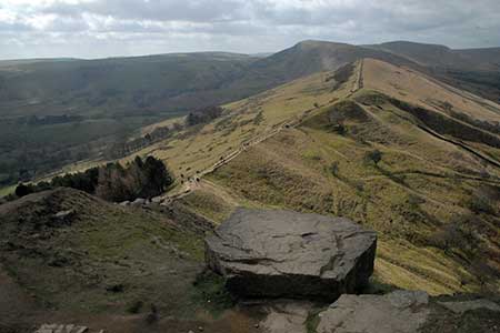
Turn left here and start climbing steadily up the access track towards Lose Hill Farm. The track bears right, then goes sharp left and continues climbing. Just after the next sharp right hand bend take the signed footpath on your left. This rising path crosses a field with Lose Hill now in sight. The path goes to the right hand end of a small plantation and then follows a fence as the climb gets slightly steeper. Cross the fence at a stile and then climb the clear path to the top of Lose Hill with its fine view and topograph. With most the ascent now complete this is the perfect place to take a break.
The onward route descends south west with a clear path all the way. Reaching Back Tor there is a steep ascent over rocky ground before the path resumes an undulating course along the ridge. Reaching Hollins Cross with another topography (grid ref. SK135845), turn sharp left (almost a U-turn) descending south-east along a rather worn and eroded path. This soon loses height and leads across open country down to a narrow walled path (grid ref. SK141841) which can wet under foot and muddy after rain. This enclosed path leads into Hollowford Lane which is followed back to the centre of Castleton.
Other walks nearby
| Walk 1688 | Old Dam & Sparrowpit from Mam Nick | moderate | 9.0 miles |
| Walk 1286 | Castleton Great Ridge & Mam Tor | moderate | 8.5 miles |
| Walk 2599 | Kinder Scout and Castleton Ridge from Hope | mod/hard | 13.5 miles |
| Walk 1706 | Win Hill from Hope | easy/mod | 6.5 miles |
| Walk 2522 | Rushup Edge & Edale from Mam Nick | moderate | 7.0 miles |
| Walk 1368 | Mam Tor, Upper Booth & Rushup Edge | moderate | 7.0 miles |
| Walk 1831 | Mam Tor & Hollins Cross from Mam Nick | easy | 3.0 miles |
| Walk 1080 | Shatton Moor and Offerton | easy/mod | 7.5 miles |
| Walk 1159 | Grindsbrook & Edale Head | moderate | 7.5 miles |
| Walk 1264 | Rushup Edge & Crowden Tower | moderate | 10.0 miles |
Recommended Books & eBooks
Walking in the Peak District - White Peak East
 Guidebook describing 42 half-day and day walks in the limestone landscapes of Derbyshire's White Peak, part of the Peak District National Park. One of two volumes, this book covers the east of the region, with potential bases including Bakewell, Eyam, Castleton, Birchover, Matlock and Wirksworth.
More information
Walking in Derbyshire
 Walking guidebook to 60 circular day walks in Derbyshire and the Peak District. Includes the Derwent, Wye and Trent river valleys, near Derby, Matlock, Glossop, Bakewell and Ripley. Routes range from easy to moderate and are between 4 and 14km (2 to 10 miles). Walks focus on places of interest, from Stone Age forts to castles to grand estates.
More information
Messaging & Social Media
Message Walking Britain and follow the latest news.

Mountain Weather
Stay safe on the mountains with detailed weather forecasts - for iOS devices or for Android devices.