Walk 1012 - printer friendly version
Glaisdale, Great Fryup Dale and Eskdale Walk
Author - Phil Catterall
Length - 7.5 miles / 12.2 km
Ascent - 1195 feet / 362 metres
Grade - moderate
Start - OS grid reference NZ763076
Lat 54.458062 + Long -0.82455357
Postcode YO21 2AH (approx. location only)
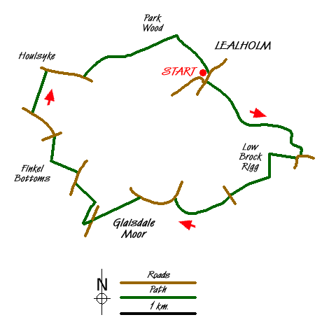
A circular walk from Lealholm taking in three Dales in the North York Moors. Ample free parking is usually available on the car park adjacent to the School in Lealholm, where there are also public toilets. Our walk starts from here at grid ref. NZ763076. Take the track ESE leading from the car park to Underpark Farm, turn right as you enter the farm yard and then follow the path alongside the River Esk. At grid ref. NZ775069 the public footpath becomes a permissive path and a footbridge crossing the Esk is soon in view. Cross here taking the rough track up the hill. Where the track meets the public road bear right on a waymarked footpath for 500m to Low Brock Rigg. On entering the muddy yard here take a sharp hairpin left to keep the hedgerow on your right. Head due south, through a field gate, then turning slightly left towards High Brock Rigg. Here you climb the low stone wall into what appears to be an extremely tidy private garden. This is actually the public footpath and the owner must be complemented for its maintenance.
At the top of the garden turn square right to follow the path of a stream, taking a right fork at the footpath junction Sunny Brake (grid ref. NZ771062). When you reach a gravel track keep right passing a bungalow on your right. This access track joins the public road at grid ref NZ766060. Turn left here and then take the track immediately on your right before the bridge, passing Lower Swang - a farm that has collected thousands of wooden pallets. Heading WSW pass between Gorse bushes and then through a field gate to emerge at an unnamed remote cottage bordering Glaisdale Moor. From here continue on the access track to join the public road (grid ref. NZ759059).
Turn left here walking downhill to Busco Beck Farm. From the farm take the left hand waymarked path over Glaisdale Moor. A large stone on the moor is visible and if you make for this it will place you on the correct heading to reach the road at grid ref. NZ747056 which is where you want to be. The walk across the heather of Glaisdale Moor is hard going as there is no defined path. An easier choice if you prefer, is to road walk up to the crossroads and then turn left.
From grid ref. NZ747056 a track west to Shaw End Farm leaves the public road, take this for only a few yards before turning sharp right on the footpath running alongside a dry stone wall, giving breathtaking views across Great Fryup Dale. Follow this path for NNE for 300m before turning left through a footpath gate and heading downhill towards Finkel House. Turn left at this farms concrete driveway briefly, before sighting a footpath gate to the right of the cattle grid. Exit here turning right on to the public road for 200m before turning left on a footpath to Finkel Bottoms. Cross a footbridge here and then turn right, crossing several stiles to reach Furnace Farm. Stay to the right of the farm buildings to emerge at the public road (grid ref. NZ741068).
Continue straight on (signposted Danby) for 400m before turning right on a waymarked path towards the River Esk. Houlsyke village can be seen to the north. Cross the Esk via the footbridge taking the left side of the hedge, as you head towards the gated railway crossing, marked by a red and white sign. Take extra care crossing the Esk Valley Line. After 200m the Lealholm to Danby road is reached (grid ref. NZ740078). Turn right for 600m. Shortly after the driveway to Lawns Farm on your left, a waymarked path takes you through several fields with stiles, north of High Park Farm. After passing through Park Wood keep left after the footbridge, to cross the top of Elm Ridge. After going through a gate keep right - waymarked Lealholm. The path becomes a track and soon the Station House is encountered at Lealholm Railway Station. Continue for 100m before turning right to cross the railway line at a pedestrian gate. The grassy path now curves left into the village street, where there is a Shop, Post Office, Garage, Tearoom and Pub. A left turn into the street returns you uphill to the village car park and toilets.
Messaging & Social Media
Message Walking Britain and follow the latest news.

Mountain Weather
Stay safe on the mountains with detailed weather forecasts - for iOS devices or for Android devices.