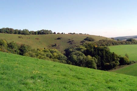
Beacon and Old Winchester Hills on the South Downs
Hampshire Walk
County/Area - Hampshire
Author - Peter Lane
Length - 10.5 miles / 17.1 km Ascent - 1100 feet / 333 metres
Time - 6 hours 20 minutes Grade - moderate
Maps 

| Ordnance Survey Explorer OL32 | Sheet Map | 1:25k | BUY |
| Anquet OS Explorer OL32 | Digital Map | 1:25k | BUY |
| Ordnance Survey Landranger 185 | Sheet Map | 1:50k | BUY |
| Anquet OS Landranger 185 | Digital Map | 1:50k | BUY |
Walk Route Description
Click image to visit gallery of 12 images.
This is a delightful walk along part of the South Downs Way visiting some quintessentially English villages and countryside. I wouldn't be surprised to find Hercule Poirot sipping a tisane at the tea rooms in Exton! There are expansive views from both hills at the west and east extremities of this walk that range as far as the Isle of Wight.
There are numerous options for start points including the car park on the summit of Old Winchester Hill at grid reference SU645213, the Meon Valley Trail car park at grid reference SU641236, or for the purposes of this write up: the car park at the foot of Beacon Hill at grid reference SU598227. Heed the warnings about keeping valuables out of sight at these car parks. The path follows the South Downs Way (walkers route) all the way to Old Winchester Hill, although some signs state that this route is a temporary one (September 2010).
From the pleasant wooded car park at the foot of Beacon Hill there is a track rising from the right side of the car park (when facing away from the road), signposted South Downs Way. Take this steadily climbing path to the summit trig point where there are some fine views. From here, descend down the signposted permissive bridlepath (not shown on OS maps) to the country lane. Turn left along the lane and in a few metres enter the field on the left signposted South Downs Way (walkers only). The route crosses a large number of fields but remains on an unerring bearing (as shown on OS maps) until Exton comes in sight and it kicks slightly left before meeting a country lane in this very picturesque village.
Turn left into Exton and enjoy its beautiful thatched cottages and flint church. Maybe stop at the South Downs tea rooms with their beautiful gardens. Follow the lane left past the church to the A32. Cross carefully and continue along a path over a footbridge. The path joins a track and then the South Downs Way turns sharp left and heads due East narrowly through trees with a dried up stream (September 2010) below. Upon reaching the old railway bridge, ascend to meet the old track-bed above. Here the route turns briefly left and almost immediately right down a winding path to a complex junction. Head half right towards a metal gate on a right hand bend, follow round to the right and then left in 150 meters as the path climbs steadily to the next objective: Old Winchester Hill.
Note the Monarch's Way heading off left as you ascend Old Winchester Hill: this is the return route. On the summit of the hill are obvious remnants of the ramparts and ditches of an old fort. There are two distinct tumuli on the summit also. Having enjoyed the views and explored the ancient monument retrace to the Monarch's Way junction and turn right, heading north to Peake Farm. Follow the waymarks around the borders of the farm and then along its access road to Hayden Lane.
Turn left on Hayden Lane and walk to the old railway bridge. Cross and take the footpath on the right immediately adjacent to the bridge. A footpath forks right from the right of way in a few metres and descends to the track-bed of the disused railway (Meon Valley Trail), now a permissive bridlepath. Follow this all the way to its end at West Meon. Reaching a country lane after leaving the car park, turn left and follow the winding road into the village. Cross the A32 and slightly left on the other side of the road is a footpath behind houses that leads to the church. The churchyard makes a good resting point or picnic spot.
The onward route is left (when facing the church) on the approach to the church, just before reaching the railings and through the graveyard over a low stone step with a square hole in the middle. The narrow winding path exits onto a drive and then into a field where it follows a higher contour parallel to the A32 below. When this path reaches a lane turn left along it down through the village of Warnford to the A32. Note the watercress beds on the way.
Turn right briefly on the A32 and almost immediately right again past more watercress beds following the Monarch's Way. Pass an agricultural works and then, just before the forge turn left past farm buildings following the Monarch's Way as it climbs steadily to the obvious objective of Beacon Hill. The path is well marked and affords good views ahead. The final stretch runs through woods back to the car park.
Other walks nearby
| Walk 2662 | Beacon Hill and Warnford | easy/mod | 6.0 miles |
| Walk 2710 | Old Winchester Hill from Exton | easy/mod | 5.5 miles |
| Walk 3324 | Cheriton Mill & Tichborne from Cheriton | easy | 5.7 miles |
| Walk 2533 | East Meon to Old Winchester Hill | moderate | 12.0 miles |
| Walk 2394 | East Meon & Wether Down | easy/mod | 8.0 miles |
| Walk 2383 | Upham & Owslebury Circular | easy/mod | 6.5 miles |
| Walk 2373 | Hambledon Circular | easy/mod | 6.1 miles |
| Walk 1964 | Abbotstone from Old Alresford | easy | 5.1 miles |
| Walk 3260 | Butser Hill Circular | easy/mod | 6.9 miles |
| Walk 2422 | Butser Hill and Wether Down from Buriton | moderate | 12.5 miles |
Recommended Books & eBooks
The South Downs Way
 Guidebook to walking the South Downs Way National Trail, a 100 mile (160km) route between Winchester and Eastbourne through the South Downs National Park, described in both directions over 12 stages. Easy walking on ancient and historical tracks, taking in wooded areas, delightful river valleys and pretty villages. With 1:25K OS map booklet.
More information
Walking Hampshire's Test Way
 Guidebook to walking the 71km (44 mile) Test Way in Hampshire from high on the chalk downs of Inkpen Beacon to the Eling Tide Mill near Southampton Water. Following the beautiful, crystal clear River Test, it passes picturesque villages and fascinating historic sites. Also includes 15 day walks to explore this lovely part of pastoral England.
More information
Messaging & Social Media
Message Walking Britain and follow the latest news.

Mountain Weather
Stay safe on the mountains with detailed weather forecasts - for iOS devices or for Android devices.