Garrigill, Alston & Nenthead Walk
Walk 1084 - Route Maps
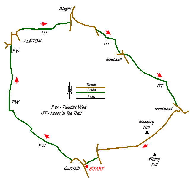
Route Map
Digital Maps - Copyright © 2011-2024. All rights reserved.
Sketch Map
Suggested Maps 

| Ordnance Survey Explorer OL31 | Sheet Map | 1:25k | BUY |
| Anquet OS Explorer OL31 | Digital Map | 1:25k | BUY |
| Ordnance Survey Landranger 87 | Sheet Map | 1:50k | BUY |
| Anquet OS Landranger 87 | Digital Map | 1:50k | BUY |
It is recommended you take a map. The preferred scale is 1:25k.
Start Point Details
Ordnance Survey Grid Ref NY745416
Latitude 54.768672 Longitude -2.397868
Postcode CA9 3DR
what3words start waxer.stow.gratuity
Walk description may contain detailed information on the start point for this walk.
Further Information
North Pennines
This National Landscape (formerly AONB), the second largest in area, covers some wild and remote landscapes in northern England. The area is dominated by the Pennine hills and includes large areas of undulating heather moors and peat. North Pennines Walking Guide
Cumbria
Cumbria is one of the finest places for walking in Britain with rugged peaks, rolling hills, lakes and valleys providing a wonderful variety of landscapes. Cumbria includes the Lake District National Park, the Howgill Fells, part of the Yorkshire Dales National Park and the highest peaks of the North Pennines so who could ask for more? Sections of the Coast to Coast, Dales Way and Pennine Way long distance paths can also be explored.
Walk grading - Learn how each walk is assessed and select a walk to suit your ability and experience by going to Walk Grading Details.
Messaging & Social Media
Message Walking Britain and follow the latest news.

Mountain Weather
Stay safe on the mountains with detailed weather forecasts - for iOS devices or for Android devices.